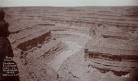
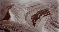
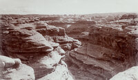
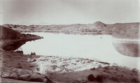
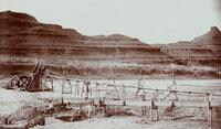
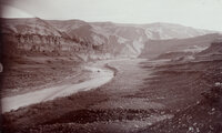
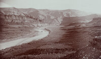
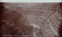
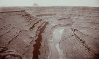
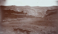
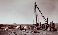
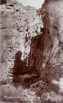
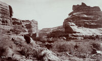
1 - 25 of 80
Number of results to display per page
TitleDateType
1 "Artesian well flowing 120 gallons of water per minute on B.D. Harshberger's farm, Bluff, Utah."1908Image
2 "Bluff City artesian well number one. Struck water on November 3rd, 1908."1908Image
3 "Crasy Smith mining in San Juan River Canyon, Utah."1894-12Image
4 "First discovery of oil in quantity on San Juan River, Utah. Oil is being poured from the bucket."1895Image
5 "General view of San Juan River Canyon, Utah at Mendenhall's camp. 1000 feet deep."1890; 1891; 1892; 1893; 1894; 1895; 1896; 1897; 1898; 1899; 1900Image
6 "Goose-neck Loop, San Juan River Canyon, 33 miles west of Bluff, Utah. Three miles around Loop and 1000 feet deep."1890; 1891; 1892; 1893; 1894; 1895; 1896; 1897; 1898; 1899; 1900Image
7 "Grand Gulch near junction with San Juan River. 600 feet deep."1890; 1891; 1892; 1893; 1894; 1895; 1896; 1897; 1898; 1899; 1900Image
8 "Hermit Lake in western San Juan Co., Utah. 12 miles east of Colorado River, 1/4 mile wide and 1/2 mile long. The Henry Mountains, faintly seen, 75 miles distant." This lake was on the famous Hole-in-the-Rock trail. The natural dam failed in 1914? The lake no longer exists.1890; 1891; 1892; 1893; 1894; 1895; 1896; 1897; 1898; 1899; 1900Image
9 "Looking southwest from Bluff, Utah."1890; 1891; 1892; 1893; 1894; 1895; 1896; 1897; 1898; 1899; 1900Image
10 "Looking southwest from Bluff, Utah."1890; 1891; 1892; 1893; 1894; 1895; 1896; 1897; 1898; 1899; 1900Image
11 "Mexican Hat on the San Juan River at Wilson's Camp."1890; 1891; 1892; 1893; 1894; 1895; 1896; 1897; 1898; 1899; 1900Image
12 "Mexican Hat or Blanced Rock in the background of placer miners. View in Oil Basin, 25 miles west of Bluff, Utah."1894Image
13 "Mokee Castle, Grand Gulch, San Juan County, Utah. Around its base and under its sheltering cliffs were found many relics of the old cliff-dwellers."1890; 1891; 1892; 1893; 1894; 1895; 1896; 1897; 1898; 1899; 1900Image
14 "Mound Loop, San Juan River Canyon. Scene in oil field 30 miles west of Bluff, Utah. Two miles around loop and 800 feet deep."1890; 1891; 1892; 1893; 1894; 1895; 1896; 1897; 1898; 1899; 1900Image
15 "Placer mining at foot of Honaker Trail in San Juan Canyon, Utah."1894-12Image
16 "Placer mining on San Juan River near Bluff, Utah."1894-07Image
17 "Raplee's placer mining works in Oil Basin, 25 miles west of Bluff, Utah."1894-12Image
18 "San Juan Oil Basin at Raplee's Camp. Lime Ridge Dome in background."1894-12Image
19 "San Juan Oil Basin at Raplee's Camp. Lime Ridge Dome in background."1894-12Image
20 "San Juan River Canyon at Honaker Trail - 1500 Feet deep."1894-12Image
21 "San Juan River Canyon at Mendenhall Loop. 1000 feet deep. Alhambra Rock in the distance. Eruptive and 450 feet high, 600 feet long and 90 feet wide."1894-12Image
22 "Some rocks, Bluff, Utah. Blue lime forms the background while deep shaded parts are red lime ot trias rocks. View from San Juan Oil Field."1890; 1891; 1892; 1893; 1894; 1895; 1896; 1897; 1898; 1899; 1900Image
23 "The first Goodridge Oil Well. Oil struck March 4, 1908."1908Image
24 "Trails to Honaker's Camp, San Juan Canyon, Utah."1894Image
25 "Victoria Camp, Grand Gulch, San Juan County, Utah. Queen Vic's profiled is seen on top of cliff, right side."1890; 1891; 1892; 1893; 1894; 1895; 1896; 1897; 1898; 1899; 1900Image
1 - 25 of 80