Home
Browse
Ask Us
Chat
Harmful Language Statement
Log in
Advanced Search
Year
1810
1811
1812
1813
1814
1815
1816
1817
1818
1819
1820
1821
1822
1823
1824
1825
1826
1827
1828
1829
1830
1831
1832
1833
1834
1835
1836
1837
1838
1839
1840
1841
1842
1843
1844
1845
1846
1847
1848
1849
1850
1851
1852
1853
1854
1855
1856
1857
1858
1859
1860
1861
1862
1863
1864
1865
1866
1867
1868
1869
1870
1871
1872
1873
1874
1875
1876
1877
1878
1879
1880
1881
1882
1883
1884
1885
1886
1887
1888
1889
1890
1891
1892
1893
1894
1895
1896
1897
1898
1899
1900
1901
1902
1903
1904
1905
1906
1907
1908
1909
1910
1911
1912
1913
1914
1915
1916
1917
1918
1919
1920
1921
1922
1923
1924
1925
1926
1927
1928
1929
1930
1931
1932
1933
1934
1935
1936
1937
1938
1939
1940
1941
1942
1943
1944
1945
1946
1947
1948
1949
1950
1951
1952
1953
1954
1955
1956
1957
1958
1959
1960
1961
1962
1963
1964
1965
1966
1967
1968
1969
1970
1971
1972
1973
1974
1975
1976
1977
1978
1979
1980
1981
1982
1983
1984
1985
1986
1987
1988
1989
1990
1991
1992
1993
1994
1995
1996
1997
1998
1999
2000
2001
2002
2003
2004
2005
2006
2007
2008
2009
2010
2011
2012
2013
2014
2015
2016
2017
2018
2019
2020
2021
2022
2023
2024
TO
1810
1811
1812
1813
1814
1815
1816
1817
1818
1819
1820
1821
1822
1823
1824
1825
1826
1827
1828
1829
1830
1831
1832
1833
1834
1835
1836
1837
1838
1839
1840
1841
1842
1843
1844
1845
1846
1847
1848
1849
1850
1851
1852
1853
1854
1855
1856
1857
1858
1859
1860
1861
1862
1863
1864
1865
1866
1867
1868
1869
1870
1871
1872
1873
1874
1875
1876
1877
1878
1879
1880
1881
1882
1883
1884
1885
1886
1887
1888
1889
1890
1891
1892
1893
1894
1895
1896
1897
1898
1899
1900
1901
1902
1903
1904
1905
1906
1907
1908
1909
1910
1911
1912
1913
1914
1915
1916
1917
1918
1919
1920
1921
1922
1923
1924
1925
1926
1927
1928
1929
1930
1931
1932
1933
1934
1935
1936
1937
1938
1939
1940
1941
1942
1943
1944
1945
1946
1947
1948
1949
1950
1951
1952
1953
1954
1955
1956
1957
1958
1959
1960
1961
1962
1963
1964
1965
1966
1967
1968
1969
1970
1971
1972
1973
1974
1975
1976
1977
1978
1979
1980
1981
1982
1983
1984
1985
1986
1987
1988
1989
1990
1991
1992
1993
1994
1995
1996
1997
1998
1999
2000
2001
2002
2003
2004
2005
2006
2007
2008
2009
2010
2011
2012
2013
2014
2015
2016
2017
2018
2019
2020
2021
2022
2023
2024
Type
Image
996
Image/StillImage
884
Sound
253
Text
112
Image/MovingImage
1
Format
image/jpeg
1,752
application/pdf
302
video/mp4
148
audio/mpeg
106
Collection
Al W. Morton Collection, 1930s-1950s
1
American Westward Migration
6
Aziz Suryal Atiya papers
2
Beckwith Photograph Collection
2
Chieko N Okazaki papers
1
Classified Photographs
133
Construyendo Latinidad (Constructing ...
2
David Oman McKay Papers
1
Everett L. Cooley Oral History Project
1
Jacob Myers Sr. Papers, 1801-2009
1
John Hamilton Morgan Papers
1
Kent Day Family Collection
26
Land Use - Transportation Scenario Pl...
10
Lennox and Catherine Tierney Photogra...
179
Life Story Library collection
1
Lloyd and Kiyomi Takehara Ryujin Phot...
2
Manuscripts
1
Marriner S. Eccles Papers
1
Mormon Settlement in Arizona
1
Olympic Legacy
2
Peoples of Utah
1
Photo Archives
1,211
Regional History Center
1
Shipler Commercial Photographers
1
Ski and Snow Sports Photo Archives
217
Taylor A. Woolley Papers
2
Theater Programs Collection, 1866-1995
1
Thorne Photographs
2
UAIDA Main Collection
50
Uintah County Regional History Center...
1
Utah Artists Project
3
Utah Humanities Research Foundation
5
Utah Quilt Heritage Records
11
Utah River Running Photo Archives
140
Vertebrate Zoology Voucher Images
28
Western Soundscape
253
Western Waters Electronic Resources
7
Western Waters NEH
2
More
Filters:
Spatial Coverage:
"California"
1101
-
1125
of
2,310
<
40
41
42
43
44
45
46
47
48
49
>
Gallery view
Number of results to display per page
10
25
50
100
200
Sort by Relevance
Sort by Title A-Z
Sort by Title Z-A
Sort by Date Ascending
Sort by Date Descending
Sort by Last Modified Ascending
Sort by Last Modified Descending
Title
Date
Type
Setname
1101
Man measuring a piece of wood.
1942; 1943
Image
uum_map
1102
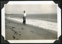
Man on beach
1937; 1938
Image/StillImage
uum_map
1103
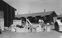
Man opens crate of clothing or bedding amid other crates
1942; 1943
Image
uum_map
1104
Man picking up a paper sack.
1942; 1943
Image
uum_map
1105
Man receiving a medical check-up.
1942; 1943
Image
uum_map
1106
Man sawing a piece of wood while another man looks on.
1942; 1943
Image
uum_map
1107
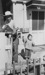
Man sawing while a child stands nearby.
1942; 1943
Image
uum_map
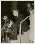
1108
Man sitting on the stairs
1940
Image/StillImage
uum_map
1109
Man standing in a road.
1942; 1943
Image
uum_map
1110
Man standing next to a large hog.
1942; 1943
Image
uum_map
1111
Man standing next to a large pig at the Hog Farm.
1942; 1943
Image
uum_map
1112
Man standing next to a pig on the Hog Farm.
1942; 1943
Image
uum_map
1113
Man standing next to a tree.
1942; 1943
Image
uum_map
1114
Man standing next to crates filled with produce.
1942; 1943
Image
uum_map
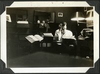
1115
Man studying
1937; 1938
Image/StillImage
uum_map
1116
Man tags for service dogs
1944-08-28
Image
uum_map
1117
Man unloading a crate from the bed of a truck.
1942; 1943
Image
uum_map
1118
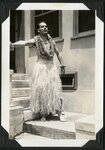
Man with grass skirt and leis
1938
Image/StillImage
uum_map
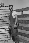
1119
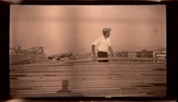
Man with lumber [Negative]
1929; 1930
Image/StillImage
uum_map
1120
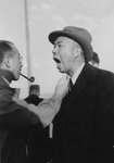
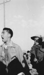
Man yelling.
1942; 1943
Image
uum_map
1121
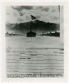
Manzanar Relocation camp, 1942
1942-07-03
Image
uum_map
1122
Manzanar Relocation Camp, 1942: information sheet
1980; 1981; 1982; 1983; 1984; 1985; 1986; 1987; 1988; 1989; 1990; 1991; 1992; 1993; 1994; 1995; 1996; 1997; 1998; 1999; 2000
Image
uum_map
1123
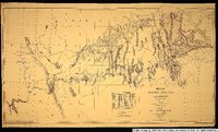
Map of wagon routes in Utah Territory explored and opened by Capt. J. H. Simpson...in 1858-59.
1859
Image/StillImage
uu_awm
1124
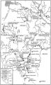
Map of Western Indian Territory Before 1850
Image/StillImage
uaida_main
1125
Map of Western Shoshone and Northern Paiute Territory
Image/StillImage
uaida_main
1101
-
1125
of
2,310
<
40
41
42
43
44
45
46
47
48
49
>