Home
Browse
Ask Us
Chat
Harmful Language Statement
Log in
Advanced Search
Year
1853
1854
1855
1856
1857
1858
1859
1860
1861
1862
1863
1864
1865
1866
1867
1868
1869
1870
1871
1872
1873
1874
1875
1876
1877
1878
1879
1880
1881
1882
1883
1884
1885
1886
1887
1888
1889
1890
1891
1892
1893
1894
1895
1896
1897
1898
1899
1900
1901
1902
1903
1904
1905
1906
1907
1908
1909
1910
1911
1912
1913
1914
1915
1916
1917
1918
1919
1920
1921
1922
1923
1924
1925
1926
1927
1928
1929
1930
1931
1932
1933
1934
1935
1936
1937
1938
1939
1940
1941
1942
1943
1944
1945
1946
1947
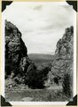
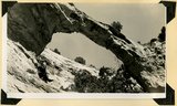
1948
1949
1950
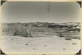
1951
1952
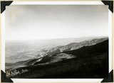
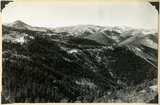
1953
1954
1955
1956
1957
1958
1959
1960
1961
1962
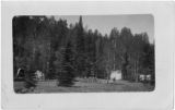
1963
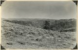
1964
1965
1966
1967
1968
1969
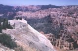
1970
1971
1972
1973
1974
1975
1976
1977
1978
1979
1980
1981
1982
1983
1984
1985
1986
1987
1988
1989
1990
1991
1992
1993
1994
1995
1996
1997
1998
TO
1853
1854
1855
1856
1857
1858
1859
1860
1861
1862
1863
1864
1865
1866
1867
1868
1869
1870
1871
1872
1873
1874
1875
1876
1877
1878
1879
1880
1881
1882
1883
1884
1885
1886
1887
1888
1889
1890
1891
1892
1893
1894
1895
1896
1897
1898
1899
1900
1901
1902
1903
1904
1905
1906
1907
1908
1909
1910
1911
1912
1913
1914
1915
1916
1917
1918
1919
1920
1921
1922
1923
1924
1925
1926
1927
1928
1929
1930
1931
1932
1933
1934
1935
1936
1937
1938
1939
1940
1941
1942
1943
1944
1945
1946
1947
1948
1949
1950
1951
1952
1953
1954
1955
1956
1957
1958
1959
1960
1961
1962
1963
1964
1965
1966
1967
1968
1969
1970
1971
1972
1973
1974
1975
1976
1977
1978
1979
1980
1981
1982
1983
1984
1985
1986
1987
1988
1989
1990
1991
1992
1993
1994
1995
1996
1997
1998
Type
Image
217
Format
image/jpeg
210
application/pdf
7
Collection
Beckwith Photograph Collection
48
Photo Archives
161
Ski and Snow Sports Archives
4
Westminster College Photographs
4
Filters:
Spatial Coverage:
"Iron County (Utah)"
Type:
"Image"
101
-
125
of
217
<
1
2
3
4
5
6
7
8
9
>
Gallery view
Number of results to display per page
10
25
50
100
200
Sort by Relevance
Sort by Title A-Z
Sort by Title Z-A
Sort by Date Ascending
Sort by Date Descending
Sort by Last Modified Ascending
Sort by Last Modified Descending
Title
Date
Type
Setname
101
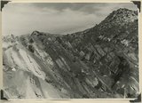
Moenkopi formation, Shnabkaib and upper red members. Chinle (upper right), knob of Shinarump offset by faulting (center skyline). Near mouth of Coal Canyon. Iron County, UT, 1942
1942
Image
uum_map
102
Mouth of Camp Creek. Resistant limestones of lowest Triassic make walls. Iron County, UT. 1941
1941
Image
uum_map
103
Natural bridge near top of wall of Ashdown Canyon, Iron County, UT, 1941
1941
Image
uum_map
104
Near west edge of Kolob Terrace, looking northeast across mouth of Coal Creek; tilted rocks at Hurricane fault (middle); Cedar City, lower left. Iron County, UT
1937; 1938
Image
uum_map
105
North Rim of canyon, Wasatch limestone. Iron Mountain in distance west. Cedar Breaks National Monument
1937; 1938
Image
uum_map
106
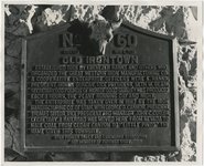
Old Irontown plaque
1945; 1946; 1947; 1948; 1949; 1950; 1951; 1952; 1953; 1954; 1955; 1956; 1957; 1958; 1959; 1960; 1961; 1962; 1963; 1964; 1965
Image
uum_map
107
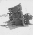
Overturned truck. (Johnson covered this open-air test in Nevada for radio station KSUB of Cedar City, Utah.)
1952-04-22
Image
uum_map
108
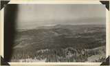
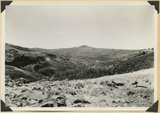
Panorama northwest of Brian Head, Markagunt Plateau. Glacial topography foreground; Wasatch formation (middle distance); Little Salt Lake in valley beyond Hurricane Cliffs. Iron County, UT
1937; 1938
Image
uum_map
109
Panorama northwest of Brian Head, Markagunt Plateau. Glacial topography foreground; Wasatch formation (middle distance); Little Salt Lake in valley beyond Hurricane Cliffs. Iron County, UT
1937; 1938
Image
uum_map
110
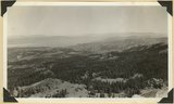
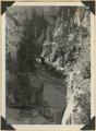
Panorama of Ashdown Canyon, 600-1800 feet deep, 20-150 feet wide out in Straight Cliffs sandstone. Iron County, UT, 1941
1941
Image
uum_map
111
Panorama of Ashdown Canyon, 600-1800 feet deep, 20-150 feet wide out in Straight Cliffs sandstone. Iron County, UT, 1941
1941
Image
uum_map
112
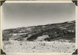
Panorama. Surface of Kolob Terrace near the head of Kolob Creek. Iron County, UT
1941; 1942
Image
uum_map
113
Panorama. Surface of Kolob Terrace near the head of Kolob Creek. Iron County, UT
1941; 1942
Image
uum_map
114
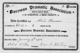
Parowan Dramatic Association stock certificate
1902
Image
uum_map
115
Parowan Tithing Office
1853; 1854; 1855; 1856; 1857; 1858; 1859
Image
uum_map
116
Parowan.
Image
wc_pc
117
Parunuweap formation, thin bedded phase; overlies upturned Moenkopi, Lawrence Canyon, Iron County, UT, 1942. View near mouth of Lawrence Canyon.
1942
Image
uum_map
118
People and a titter-totter. Esplin family outing on Cedar Mountain (Iron County)
Image
uum_map
119
Piute Highlands. Glacial lake and moraine, Moseman (Dry Lakes) Valley. Iron County, UT, 1942
1942
Image
uum_map
120
Piute Highlands. View looking north from near the base of Eagle Peak across branches of Summit Creek. Parowan Creek to snow capped Tushar Mountains (skyline); rhyolite and Cretaceous in the foreground; Cretaceous, Tertiary, and lavas beyond. Iron County, UT, 1942
1942
Image
uum_map
121
Piute Highlands. View looking northeast across Parowan and Benson Canyons from base of Applegate Ridge. Rim of Markagunt Plateau (middle skyline); Knob and ridges of Wasatch (middle distance); rhyolite foreground. Iron County, UT. 1942
1942
Image
uum_map
122
Piute Highlands. View looking northeast across Parowan and Benson Canyons from base of Applegate Ridge. Rim of Markagunt Plateau (middle skyline); Knob and ridges of Wasatch (middle distance); rhyolite foreground. Iron County, UT. 1942
1942
Image
uum_map
123
Piute Highlands. View looking south from Applegate Ridge across upper Summit Creek. Wasatch in Sugar Loaf Peak (upper left); rhyolite on Summit ridge, middle skyline; Cretaceous (foreground). Iron County, UT, 1942
1942
Image
uum_map
124
Pond confined by a glacial moraine. Dry Lakes road, Iron County, UT, 1942
1942
Image
uum_map
125
Portion of two-mile trail at Cedar Breaks
1966-07-04
Image
uum_map
101
-
125
of
217
<
1
2
3
4
5
6
7
8
9
>