|
|
Title | Collection Number And Name | Photo Number |
| 101 |
 |
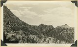
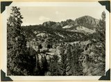
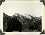
Wilson Peak, head of Hillsdale Canyon. Wasatch limestone overlying the Kaiparowits formation. Garfield County, UT, 1940 | P0013 Herbert E. Gregory Photograph Collection | P0013n11_123_2711 |
| 102 |
 |
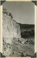
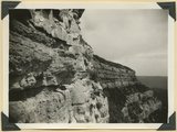
View in Hillsdale Gap in Sunset Cliffs looking east; along a fault masses of Wasatch (center and right) are dropped below corresponding beds (upper left). Garfield County, UT, 1940 | P0013 Herbert E. Gregory Photograph Collection | P0013n11_124_2712 |
| 103 |
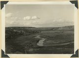 |
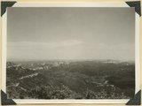
Sevier River Valley north of Hatch, UT | P0013 Herbert E. Gregory Photograph Collection | P0013n11_124_2713 |
| 104 |
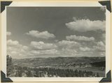 |
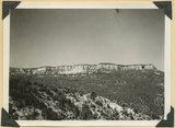
View eastward from mouth of Castle Wash, upper Sevier River (foreground) and alluvial fans (center), to Cretaceous and Tertiary beds in Sunset Cliffs (background). Kane County, UT, 1940 | P0013 Herbert E. Gregory Photograph Collection | P0013n11_125_2714 |
| 105 |
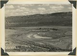 |
Meanders of Sevier River | P0013 Herbert E. Gregory Photograph Collection | P0013n11_125_2715 |
| 106 |
 |
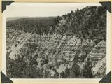
Erosion remnants in upper (white) part of Wasatch formation: limestone and conglomerate. Castle Wash an upper tributary to Sevier River. Kane County, UT, 1940 | P0013 Herbert E. Gregory Photograph Collection | P0013n11_126_2716 |
| 107 |
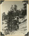 |
Foxtail pine, Bryce Canyon National Park | P0013 Herbert E. Gregory Photograph Collection | P0013n11_127_2717 |
| 108 |
 |
Walls of alluvium along Red Creek. Garfield County, UT, 1940 | P0013 Herbert E. Gregory Photograph Collection | P0013n11_127_2718 |
| 109 |
 |
Walls of alluvium along Red Creek, with post-Wasatch underlying (right). Garfield County, UT, 1940 | P0013 Herbert E. Gregory Photograph Collection | P0013n11_128_2719 |
| 110 |
 |
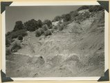
Alluvial wall of trench dug since 1920(?), post Wasatch marls at base. Red Creek. Garfield County, UT, 1940 | P0013 Herbert E. Gregory Photograph Collection | P0013n11_128_2720 |
| 111 |
 |
Bedded clays and lime silts. Pleistocene(?) lacustrine deposits overlain by basalt, Castro Canyon. Garfield County, UT, 1940 | P0013 Herbert E. Gregory Photograph Collection | P0013n11_130_2721 |
| 112 |
 |
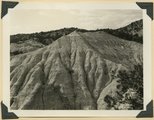
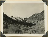
Post Wasatch Sevier(?) formation (foreground and center) capped by lavas of Sevier Plateau (horizon) at head of north fork of Linekiln Wash. Garfield County, UT, 1940 | P0013 Herbert E. Gregory Photograph Collection | P0013n11_132_2722 |
| 113 |
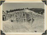 |
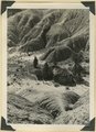
Post-Wasatch Sevier(?) formation, upper part) green sandstone in columns, white, cherty limestone and lava(top) | P0013 Herbert E. Gregory Photograph Collection | P0013n11_133_2723 |
| 114 |
 |
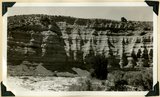
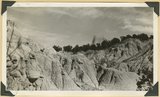
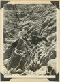
Post-Wasatch Sevier(?) formation, lower part: erosion features of clays and silts | P0013 Herbert E. Gregory Photograph Collection | P0013n11_133_2724 |
| 115 |
 |
Post-Wasatch Sevier(?) formation, lower part: erosion features of clays and silts | P0013 Herbert E. Gregory Photograph Collection | P0013n11_134_2725 |
| 116 |
 |
Post-Wasatch Sevier(?) formation, lower part: erosion features of clays and silts | P0013 Herbert E. Gregory Photograph Collection | P0013n11_134_2726 |
| 117 |
 |
Post-Wasatch Sevier(?) formation, lower part: erosion features of clays and silts | P0013 Herbert E. Gregory Photograph Collection | P0013n11_135_2727 |
| 118 |
 |
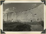
Shnabkaib member of the Moenkopi formation upturned in a fold which involves upper red beds (right), Coal Canyon. Iron County, UT. 1940 | P0013 Herbert E. Gregory Photograph Collection | P0013n11_135_2728 |
| 119 |
 |
Shnabkaib member of the Moenkopi formation upturned in a fold which involves upper red beds (right), Coal Canyon. Iron County, UT. 1940 | P0013 Herbert E. Gregory Photograph Collection | P0013n11_136_2729 |
| 120 |
 |
Winsor formation, two miles northeast of Horseranch Point, Zion National Monument. Iron County, UT, 1940 | P0013 Herbert E. Gregory Photograph Collection | P0013n11_137_2730 |
| 121 |
 |
View looking down Virgin River from Hornet Point, towers of Zion National Park in distance. Washington County, UT, 1940 | P0013 Herbert E. Gregory Photograph Collection | P0013n11_137_2731 |
| 122 |
 |
Carmel formation and Entrada (upper right) near mouth of Deep Creek. Washington County, UT, 1940 | P0013 Herbert E. Gregory Photograph Collection | P0013n11_138_2732 |
| 123 |
 |
Straight Cliffs sandstone, head of Oak Creek, Washington County, UT, 1940 | P0013 Herbert E. Gregory Photograph Collection | P0013n11_138_2733 |
| 124 |
 |
Straight Cliffs sandstone, east side of Deep Creek. Washington County, UT, 1940 | P0013 Herbert E. Gregory Photograph Collection | P0013n11_139_2734 |
| 125 |
 |
Straight Cliffs sandstone, coquina at upper left, near junction of Deep and Crystal Creeks. Washington County, UT, 1940 | P0013 Herbert E. Gregory Photograph Collection | P0013n11_139_2735 |