|
|
Title | Collection Number And Name | Photo Number |
| 151 |
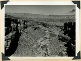 |
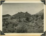
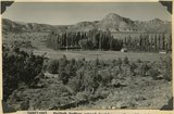
Timpoweap Canyon at mouth of Alkali Wash (enters right center). Fossiliferous Permian at stream level. Triassic limestone outer walls. Intervening slope of conglomerate and calcareous sandstones, Washington County, UT. 1939 | P0013 Herbert E. Gregory Photograph Collection | P0013n11_072_2645 |
| 152 |
 |
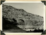
South wall of Timpoweap Canyon near mouth of Alkali Wash. Kaibab limestone (base), two beds of conglomerate separated by erosion surface, Moenkopi limestone top, Washington County, UT. 1939 | P0013 Herbert E. Gregory Photograph Collection | P0013n11_072_2646 |
| 153 |
 |
Permian-Triassic contact in Goulds Canyon (of little Creek). Kaibab (lowest ledge), conglomerate (second ledge), Moenkopi (third ledge and top). Washington County, UT. 1939 | P0013 Herbert E. Gregory Photograph Collection | P0013n11_073_2647 |
| 154 |
 |
Erosion surface produced by bevelling Chinle strata at the base of Vermillion Cliffs south of Cane Beds, Mohave County, AZ, 1939 | P0013 Herbert E. Gregory Photograph Collection | P0013n11_073_2648 |
| 155 |
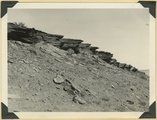 |
Moenkopi showing typical erosion of its shaly sandstones on Hurricane-Antelope Springs Road, Mohave County, AZ. 1939 | P0013 Herbert E. Gregory Photograph Collection | P0013n11_074_2649 |
| 156 |
 |
Divide dike basalt intruded in Moenkopi beds, head of Workman Wash, Washington County, UT, 1939 | P0013 Herbert E. Gregory Photograph Collection | P0013n11_074_2650 |
| 157 |
 |
Fault in lower Moenkopi shaly sandstone head of Rock Canyon (of Short Creek), Mohave County, AZ, 1939 | P0013 Herbert E. Gregory Photograph Collection | P0013n11_075_2651 |
| 158 |
 |
Folds in Moenkopi strata, Short Creek east of Rock Canyon, Mohave County, AZ, 1939 | P0013 Herbert E. Gregory Photograph Collection | P0013n11_075_2652 |
| 159 |
 |
South wall of Rock Canyon. Kaibab (on valley floor and up to first ledge), conglomerate, Moenkopi (upper part of slope and the cliffs), Mohave County, AZ, 1939 | P0013 Herbert E. Gregory Photograph Collection | P0013n11_076_2653 |
| 160 |
 |
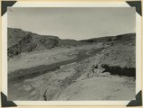
Short Creek near the exit from its canyon, in Vermillion Cliffs. Alluvial terraces and broad channel made during past 50 years, Mohave County, AZ, 1939 | P0013 Herbert E. Gregory Photograph Collection | P0013n11_076_2654 |
| 161 |
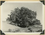 |
Cottonwood trees buried by sand dunes; trunks reexposed by recent excavations of alluvial valley fill, Short Creek, Mohave County, AZ, 1939 | P0013 Herbert E. Gregory Photograph Collection | P0013n11_077_2655 |
| 162 |
 |
Alluvial terraces made since 1900, Johnson Creek, Kane County, UT, 1939 | P0013 Herbert E. Gregory Photograph Collection | P0013n11_077_2656 |
| 163 |
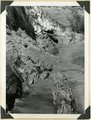 |
Spring (lower left) on local fault marked by displacement and slickensides (lower left), Johnson Canyon, Kane County, UT, 1939 | P0013 Herbert E. Gregory Photograph Collection | P0013n11_078_2657 |
| 164 |
 |
'The Granary': one of many natural cavities in Wingate sandstone utilized for storage, Johnson Canyon, Kane County, UT, 1939 | P0013 Herbert E. Gregory Photograph Collection | P0013n11_078_2658 |
| 165 |
 |
Entrada, Curtis, and Winsor formation overlain by Dakota (extreme top), Alton-Skutumpah road, Kane County, UT, 1939 | P0013 Herbert E. Gregory Photograph Collection | P0013n11_079_2659 |
| 166 |
 |
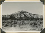
Lava flow from Bald Knoll Crater (foreground), Upper Jurassic (lower cliffs), and tertiary (upper cliffs), Kane County, UT, 1939 | P0013 Herbert E. Gregory Photograph Collection | P0013n11_079_2660 |
| 167 |
 |
Lake, one of three in LaVanger Wash. Surrounding trills Wasatch formation. Original obstruction of stream by alluvial fans made permanent by artificial dam, Kane County, UT, 1939 | P0013 Herbert E. Gregory Photograph Collection | P0013n11_081_2661 |
| 168 |
 |
Kaiparowits formation along Parunuweap below lava narrows, Kane County, UT, 1939 | P0013 Herbert E. Gregory Photograph Collection | P0013n11_081_2662 |
| 169 |
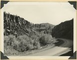 |
Lava Narrows. The Parunuweap has worn its way through basalt that filled its original canyon. Stream flows in groove at side of road, Kane County, UT, 1939 | P0013 Herbert E. Gregory Photograph Collection | P0013n11_082_2663 |
| 170 |
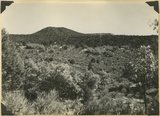 |
Corral Knoll volcanic cone, Kanab Valley, Kane County, Carmel limestone covered with lava (foreground), Cretaceous cliffs distance, Kane Co., UT. 1939 | P0013 Herbert E. Gregory Photograph Collection | P0013n11_085_2666 |
| 171 |
 |
View looking north down Workman Wash from divide between Little Creek and Short Creek. Basalt (left), terrace on Virgin member of Moenkopi (middle), upper Moenkopi (right). Moenkopi, Shinarump, Chinle, and Navajo (distance), Kane County, UT. 1939 | P0013 Herbert E. Gregory Photograph Collection | P0013n11_086_2667 |
| 172 |
 |
Vermillion Cliffs (Chinle and Navajo), north of edge of Uinkaret Plateau (foreground), mouth of Short Creek, Kane County, UT, 1939 | P0013 Herbert E. Gregory Photograph Collection | P0013n11_088_2668 |
| 173 |
 |
Big Plains, west dipping surface eroded on east dipping Chinle beds, now coated with coalescing fans. Little Creek Terrace in right background, Kane County, UT, 1939 | P0013 Herbert E. Gregory Photograph Collection | P0013n11_088_2669 |
| 174 |
 |
Kaibab Indian School near Moccasin looking northeast toward head of Two Mile Wash. Deep alluvial fill. Moenkopi capped by Shinarump (upper right), Chinle and Glen Canyon beds cliffs at upper left and middle distance (Lambs Point). Branch of Sevier fault crosses divide between Two Mile Wash and Sand Creek at base of Indian Point (left middle), Mohave County, AZ. 1939 | P0013 Herbert E. Gregory Photograph Collection | P0013n11_089_2670 |
| 175 |
 |
Kaibab Indian School looking north. Alluvial flats at head of Two Mile Wash. Branch of Sevier fault passes between Navajo (left distance) and Chinle-Navajo (middle distance), Mohave County, AZ. 1939 | P0013 Herbert E. Gregory Photograph Collection | P0013n11_089_2671 |