|
|
Title | Collection Number And Name | Photo Number |
| 151 |
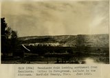 |
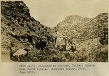
Escalante fold looking northeast from Escalante. McElmo is in foreground, LaPlata in the distance. Garfield County, UT. June 1918 | P0013 Herbert E. Gregory Photograph Collection | P0013n08_085_1468 |
| 152 |
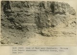 |
Bank of Wash near Escalante. Texture like Dakota sandstone. Garfield County, UT. June 1918 | P0013 Herbert E. Gregory Photograph Collection | P0013n08_086_1469 |
| 153 |
 |
Crossing Escalante River at point where sand dunes bury the canyon walls, near mouth of Silver Falls Canyon. Garfield County, UT. June 1918 | P0013 Herbert E. Gregory Photograph Collection | P0013n08_086_1470 |
| 154 |
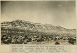 |
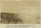
Kaiparowits, looking across Mancos landslide. Material from top of Dakota. Mesa Verde strata. Garfield County, UT. June 1918 | P0013 Herbert E. Gregory Photograph Collection | P0013n08_086_1470a |
| 155 |
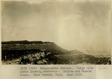 |
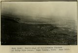
Kaiparowits Plateau. Forty mile point looking northwest. McElmo and Dakota bench. Kane County, UT. June 1918 | P0013 Herbert E. Gregory Photograph Collection | P0013n08_087_1471 |
| 156 |
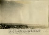 |
Kaiparowits Plateau. Forty mile Point. McElmo and Dakota projecting bench. Kane County, UT. June 1918 | P0013 Herbert E. Gregory Photograph Collection | P0013n08_087_1472 |
| 157 |
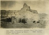 |
Kaiparowits Plateau, Forty Mile Point. McElmo Cliffs capped by Dakota. Kane County, UT. June 1918 | P0013 Herbert E. Gregory Photograph Collection | P0013n08_088_1473 |
| 158 |
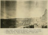 |
Kaiparowits Plateau, Forty Mile Point. McElmo Cliffs capped by Dakota, landslide material resting on it. Kane County, UT. June 1918 | P0013 Herbert E. Gregory Photograph Collection | P0013n08_088_1474 |
| 159 |
 |
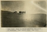
Hole-in-the-Rock Trail to Colorado River. Looking east across River. LaPlata sandstone walls. Kane County, UT. June 1918 | P0013 Herbert E. Gregory Photograph Collection | P0013n08_089_1475 |
| 160 |
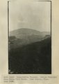 |
Kaiparowits Plateau. Navajo Mountain from Fifty Mile Point. Kane County, UT. June 1918 | P0013 Herbert E. Gregory Photograph Collection | P0013n08_089_1476 |
| 161 |
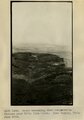 |
Bench extending from Kaiparowits Plateau near Fifty Mile Point. Kane County, UT. June 1918 | P0013 Herbert E. Gregory Photograph Collection | P0013n08_090_1477 |
| 162 |
 |
Kaiparowits Plateau. Earth Pillar in Landslide material. Fifty Mile Point. Kane County, UT. June 1918 | P0013 Herbert E. Gregory Photograph Collection | P0013n08_090_1478 |
| 163 |
 |
North edge of Kaiparowits Plateau at Fifty Mile Point. Kane County, UT. June 1918 | P0013 Herbert E. Gregory Photograph Collection | P0013n08_091_1479 |
| 164 |
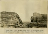 |
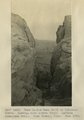
Hole-in-the-Rock Trail to Colorado River, from head of trail. Kane County, UT. June 1918 | P0013 Herbert E. Gregory Photograph Collection | P0013n08_091_1480 |
| 165 |
 |
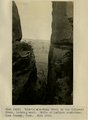
Hole-in-the-Rock Trail, Colorado River. From within the trail chasm looking across the river. Kane County, UT. June 1918 | P0013 Herbert E. Gregory Photograph Collection | P0013n08_092_1481 |
| 166 |
 |
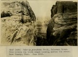
Hole-in-the-Rock Trail to the Colorado River, looking east. Walls of LaPlata sandstone. Kane County, UT. June 1918 | P0013 Herbert E. Gregory Photograph Collection | P0013n08_092_1482 |
| 167 |
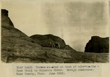 |
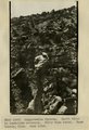
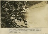
Horses in rock at head of Hole-in-the-Rock Trail to Colorado River. Navajo sandstone. Kane County, UT. June 1918 | P0013 Herbert E. Gregory Photograph Collection | P0013n08_092_1483 |
| 168 |
 |
Kaiparowits Plateau. Earth Pillar. Landslide material. Fifty Mile Trail. Kane County, UT. June 1918 | P0013 Herbert E. Gregory Photograph Collection | P0013n08_093_1484 |
| 169 |
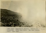 |
Kaiparowits Plateau. Surface of landslide. Fifty Mile Trail. San Juan County, UT. June 1918 | P0013 Herbert E. Gregory Photograph Collection | P0013n08_093_1485 |
| 170 |
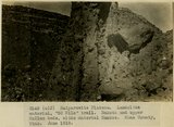 |
Kaiparowits Plateau. Landslide material, '50 Mile' trail. Dakota and upper McElmo beds, slide material Mancos. Kane County, UT. June 1918 | P0013 Herbert E. Gregory Photograph Collection | P0013n08_093_1486 |
| 171 |
 |
Top of Kaiparowits Plateau at east end. Kane County, UT. June 1918 | P0013 Herbert E. Gregory Photograph Collection | P0013n08_094_1487 |
| 172 |
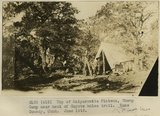 |
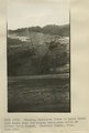
Top of Kaiparowits Plateau, Sheep Camp near head of Coyote holes trail. Kane County, UT. June 1918 | P0013 Herbert E. Gregory Photograph Collection | P0013n08_094_1488 |
| 173 |
 |
Trail on Navajo sandstone near mouth of Escalante. Kane County, UT. June 1918 | P0013 Herbert E. Gregory Photograph Collection | P0013n08_095_1489 |
| 174 |
 |
Kaiparowits Plateau, Camp Collett Canyon. Mesa Verde strata. Garfield County, UT. June 1918 | P0013 Herbert E. Gregory Photograph Collection | P0013n08_095_1490 |
| 175 |
 |
Kaiparowits Plateau, Collett Canyon. Mesa Verde strata. Garfield County, UT. June 1918 | P0013 Herbert E. Gregory Photograph Collection | P0013n08_096_1491 |