Home
Browse
Ask Us
Chat
Harmful Language Statement
Log in
Photo Archives
Advanced Search
About
Over 70,000 photos covering a variety of topics from Marriott Library Special Collections
Year
1845
1846
1847
1848
1849
1850
1851
1852
1853
1854
1855
1856
1857
1858
1859
1860
1861
1862
1863
1864
1865
1866
1867
1868
1869
1870
1871
1872
1873
1874
1875
1876
1877
1878
1879
1880
1881
1882
1883
1884
1885
1886
1887
1888
1889
1890
1891
1892
1893
1894
1895
1896
1897
1898
1899
1900
1901
1902
1903
1904
1905
1906
1907
1908
1909
1910
1911
1912
1913
1914
1915
1916
1917
1918
1919
1920
1921
1922
1923
1924
1925
1926
1927
1928
1929
1930
1931
1932
1933
1934
1935
1936
1937
1938
1939
1940
1941
1942
1943
1944
1945
1946
1947
1948
1949
1950
1951
1952
1953
1954
1955
1956
1957
1958
1959
1960
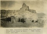
1961
1962
1963
1964
1965
1966
1967
1968
1969
1970
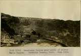
1971
1972
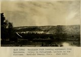
1973
1974
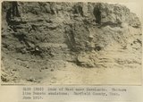
1975
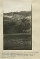
1976
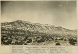
1977
1978
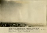
1979
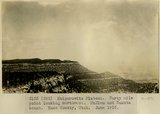
1980
TO
1845
1846
1847
1848
1849
1850
1851
1852
1853
1854
1855
1856
1857
1858
1859
1860
1861
1862
1863
1864
1865
1866
1867
1868
1869
1870
1871
1872
1873
1874
1875
1876
1877
1878
1879
1880
1881
1882
1883
1884
1885
1886
1887
1888
1889
1890
1891
1892
1893
1894
1895
1896
1897
1898
1899
1900
1901
1902
1903
1904
1905
1906
1907
1908
1909
1910
1911
1912
1913
1914
1915
1916
1917
1918
1919
1920
1921
1922
1923
1924
1925
1926
1927
1928
1929
1930
1931
1932
1933
1934
1935
1936
1937
1938
1939
1940
1941
1942
1943
1944
1945
1946
1947
1948
1949
1950
1951
1952
1953
1954
1955
1956
1957
1958
1959
1960
1961
1962
1963
1964
1965
1966
1967
1968
1969
1970
1971
1972
1973
1974
1975
1976
1977
1978
1979
1980
Type
Image
2,360
Format
image/jpeg
2,360
Collection Name
Shipler Studio
535
Emigration Canyon History
208
Alta Club
202
Newell Beeman
191
Edward P. Jennings
187
Rocky Mountain Power Company
140
Herbert E. Gregory
114
Charles Neal
108
Albion W. and Agnes Sharp Caine
89
George D. Pyper
86
Mining Photograph Collection
83
Greek Archives
65
Fort Douglas
52
Philip T. Blair
33
Joe Hill Conference
30
Seamount Family
28
Hope A. Hilton
25
Rosezella Dalton Hardy
25
Joe Hill
21
Henry Y. Kasai
16
Preston Nutter Corporation
14
Everett Ruess Family
10
Japanese Church of Christ
8
The Great Salt Lake
7
Utah Humanities Research Foundation
7
B.H. Roberts
6
Orvil LaVell Sadler
6
Ole Pettit
5
Olive Woolley Burt
5
Southern Slavic
4
Duchesne, Utah
3
George A. Smith
3
John Esplin
3
Lyman P. Hunter
3
Melba Goff Matthews
3
Stephanie Young Merzel
3
Wallace Stegner
3
William Caine Patrick
3
Agnes Just Reid
2
Barbara J. Hamblin
2
Clifford Evans
2
Italian
2
Military
2
Park City, Utah
2
U of U Presidents
2
Angus Woodbury
1
B. William Allred
1
Charles Kelly
1
Colorado
1
Hampton C. Godbe
1
Harold Dalgliesh
1
Helper, Utah
1
Hiram B. Clawson
1
LDS Church History
1
Leo Leonard
1
Marsha Midgley Ballif
1
Miles Pratt Romney
1
More
Filters:
Date:
"1918"
Format:
"image/jpeg"
Collection:
"uum_map"
Type:
"Image"
126
-
150
of
2,360
<
1
2
3
4
5
6
7
8
9
10
>
Gallery view
Number of results to display per page
10
25
50
100
200
Sort by Relevance
Sort by Title A-Z
Sort by Title Z-A
Sort by Date Ascending
Sort by Date Descending
Sort by Last Modified Ascending
Sort by Last Modified Descending
Sort by Photo Number
Title
Collection Number And Name
Photo Number
126
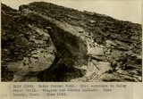
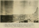
Crest of Water Pocket Fold, above Smith's Ranch. Kane County, UT. June 1918
P0013 Herbert E. Gregory Photograph Collection
P0013n08_078_1454
127
Crest of Water Pocket Fold, east face. Knobs of LaPlata sandstone. Kane County, UT. June 1918
P0013 Herbert E. Gregory Photograph Collection
P0013n08_079_1455
128
Water Pocket Fold. Hall Creek near slide. LaPlata sandstone to the left, McElmo capped by Dakota to the right. Kane County, UT. June 1918
P0013 Herbert E. Gregory Photograph Collection
P0013n08_079_1456
129
Water Pocket Fold. East entrance to Muley Twist Trail. Wingate and Middle LaPlata. Kane County, UT. June 1918
P0013 Herbert E. Gregory Photograph Collection
P0013n08_080_1457
130
Water Pocket Fold. West entrance to Muley Twist trail. Navajo on middle LaPlata. Kane County, UT. June 1918
P0013 Herbert E. Gregory Photograph Collection
P0013n08_080_1458
131
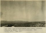
Axis of Water Pocket Fold looking southwest standing on Chinle. Wingate in distance. Kane County, UT. June 1918
P0013 Herbert E. Gregory Photograph Collection
P0013n08_081_1459
132
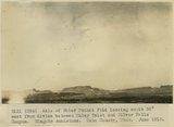
Axis of Water Pocket Fold looking south 30 degrees west from divide between Muley Twist and Silver Falls Canyon. Wingate sandstone. Kane County, UT. June 1918
P0013 Herbert E. Gregory Photograph Collection
P0013n08_081_1460
133
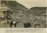
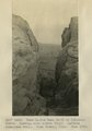
Scene in Silver Falls Canyon.Garfield County, UT. June 1918
P0013 Herbert E. Gregory Photograph Collection
P0013n08_082_1461
134
Upper Silver Falls Canyon. Chinle strata below Wingate. Garfield County, UT. June 1918
P0013 Herbert E. Gregory Photograph Collection
P0013n08_082_1462
135
Upper Silver Falls Canyon. Chinle beds below Wingate. Garfield County, UT. June 1918
P0013 Herbert E. Gregory Photograph Collection
P0013n08_083_1463
136
Silver Falls Canyon. Middle LaPlata and Navajo sandstone. Garfield County, UT. June 1918
P0013 Herbert E. Gregory Photograph Collection
P0013n08_083_1464
137
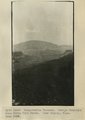
Escalante Canyon near mouth of Silver Falls Canyon. Garfield County, UT. June 1918
P0013 Herbert E. Gregory Photograph Collection
P0013n08_084_1465
138
Harris Canyon, tributary to Escalante Canyon. Navajo strata. Garfield County, UT. June 1918
P0013 Herbert E. Gregory Photograph Collection
P0013n08_084_1466
139
Escalante gorge, looking from Escalante across river flat. Garfield County, UT. June 1918
P0013 Herbert E. Gregory Photograph Collection
P0013n08_085_1467
140
Escalante fold looking northeast from Escalante. McElmo is in foreground, LaPlata in the distance. Garfield County, UT. June 1918
P0013 Herbert E. Gregory Photograph Collection
P0013n08_085_1468
141
Bank of Wash near Escalante. Texture like Dakota sandstone. Garfield County, UT. June 1918
P0013 Herbert E. Gregory Photograph Collection
P0013n08_086_1469
142
Crossing Escalante River at point where sand dunes bury the canyon walls, near mouth of Silver Falls Canyon. Garfield County, UT. June 1918
P0013 Herbert E. Gregory Photograph Collection
P0013n08_086_1470
143
Kaiparowits, looking across Mancos landslide. Material from top of Dakota. Mesa Verde strata. Garfield County, UT. June 1918
P0013 Herbert E. Gregory Photograph Collection
P0013n08_086_1470a
144
Kaiparowits Plateau. Forty mile point looking northwest. McElmo and Dakota bench. Kane County, UT. June 1918
P0013 Herbert E. Gregory Photograph Collection
P0013n08_087_1471
145
Kaiparowits Plateau. Forty mile Point. McElmo and Dakota projecting bench. Kane County, UT. June 1918
P0013 Herbert E. Gregory Photograph Collection
P0013n08_087_1472
146
Kaiparowits Plateau, Forty Mile Point. McElmo Cliffs capped by Dakota. Kane County, UT. June 1918
P0013 Herbert E. Gregory Photograph Collection
P0013n08_088_1473
147
Kaiparowits Plateau, Forty Mile Point. McElmo Cliffs capped by Dakota, landslide material resting on it. Kane County, UT. June 1918
P0013 Herbert E. Gregory Photograph Collection
P0013n08_088_1474
148
Hole-in-the-Rock Trail to Colorado River. Looking east across River. LaPlata sandstone walls. Kane County, UT. June 1918
P0013 Herbert E. Gregory Photograph Collection
P0013n08_089_1475
149
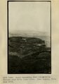
Kaiparowits Plateau. Navajo Mountain from Fifty Mile Point. Kane County, UT. June 1918
P0013 Herbert E. Gregory Photograph Collection
P0013n08_089_1476
150
Bench extending from Kaiparowits Plateau near Fifty Mile Point. Kane County, UT. June 1918
P0013 Herbert E. Gregory Photograph Collection
P0013n08_090_1477
126
-
150
of
2,360
<
1
2
3
4
5
6
7
8
9
10
>