Home
Browse
Ask Us
Chat
Harmful Language Statement
Log in
Photo Archives
Advanced Search
About
Over 70,000 photos covering a variety of topics from Marriott Library Special Collections
Year
1938
1939
1940
1941
1942
TO
1938
1939
1940
1941
1942
Type
Image
56
Format
image/jpeg
54
application/pdf
2
Collection
Photo Archives
56
Filters:
Collection Name:
"Herbert E. Gregory"
Date:
"1940"
1
-
25
of
56
<
1
2
3
>
Gallery view
Number of results to display per page
10
25
50
100
200
Sort by Relevance
Sort by Title A-Z
Sort by Title Z-A
Sort by Date Ascending
Sort by Date Descending
Sort by Last Modified Ascending
Sort by Last Modified Descending
Title
Date
Type
1
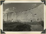
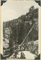
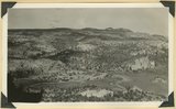
'White Throne' remnant of Navajo sandstone in branch of Paria River. Kane County, UT, 1940
1940
Image
2
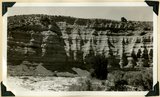
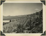
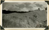
Alluvial wall of trench dug since 1920(?), post Wasatch marls at base. Red Creek. Garfield County, UT, 1940
1940
Image
3
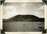
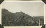
Bald Knoll Volcanic Cone near head of Johnson Creek. Kane County, UT. 1940
1940
Image
4
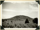
Bald Knoll Volcanic Cone near head of Johnson Creek. Kane County, UT. 1940
1940
Image
5
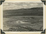
Bedded clays and lime silts. Pleistocene(?) lacustrine deposits overlain by basalt, Castro Canyon. Garfield County, UT, 1940
1940
Image
6
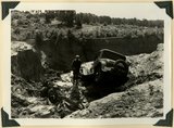
Car washed into a ravine by flood. Skutumpah-Swallow Park road
1940
Image
7
Carmel formation and Entrada (upper right) near mouth of Deep Creek. Washington County, UT, 1940
1940
Image
8
East Creek Valley, Union Pacific pump house
1939; 1940
Image
9
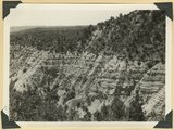
Eroded edge of basalt flow from Bald Knoll. White Cliffs, Navajo sandstone (upper right); middle Johnson Canyon. Kane County, UT, 1940
1940
Image
10
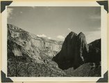
Erosion features near the head of Taylor Creek, towers and walls of Navajo sandstone overlaid by Carmel limestone and lavas (top right and center). Washington County, UT, 1940
1940
Image
11
Erosion of Cretaceous beds in Paria Valley east of Tropic; Wasatch formation on horizon. View looking east near mouth of Henderson Valley. Garfield County, UT. 1940
1940
Image
12
Erosion remnants in upper (white) part of Wasatch formation: limestone and conglomerate. Castle Wash an upper tributary to Sevier River. Kane County, UT, 1940
1940
Image
13
Fault, Navajo sandstone (right), Carmel formation (left), head of box canyon in Lick Wash. Kane County, UT, 1940
1940
Image
14
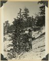
Foxtail pine, Bryce Canyon National Park
1940
Image
15
Gypsum bed, Curtis overlying Entrada, Averett Wash
1940
Image
16
Herbert E. Gregory Book 11: Colorado Plateau, 1938-1942
1938; 1939; 1940; 1941; 1942
Image
17
Junction of Deer Range and Bullrush Canyons. Highland of Navajo sandstone (upper left), Park Wash lower left: Panoramic with no. 2700. Kane County, UT, 1940
1940
Image
18
Junction of Deer Range and Bullrush Canyons. Highland of Navajo sandstone (upper left), Park Wash lower left: Panoramic with no. 2700. Kane County, UT, 1940
1940
Image
19
Lower red beds of the Moenkopi formation near mouth of Taylor Creek, flat land (left center), on downthrow side of Hurricane fault, Kanarraville. Washington County, UT, 1940
1940
Image
20
Meanders of Sevier River
1940
Image
21
Moenkopi formation showing in succession Shnabkaib, lower red, Virgin limestone (double rich), middle red, Shnabkaib, and upper red member; Shinarump conglomerate (crest and top of cuesta), Chinle including Springdale member (low cliff, upper left): Taylor Creek. Washington County, UT, 1940
1940
Image
22
Petrified forest member of the Chinle formation, Taylor Creek. Washington County, UT, 1940
1940
Image
23
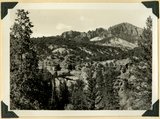
Post Wasatch Sevier(?) formation (foreground and center) capped by lavas of Sevier Plateau (horizon) at head of north fork of Linekiln Wash. Garfield County, UT, 1940
1940
Image
24
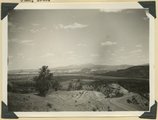
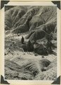
Post-Wasatch Sevier(?) formation, lower part: erosion features of clays and silts
1940
Image
25
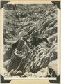
Post-Wasatch Sevier(?) formation, lower part: erosion features of clays and silts
1940
Image
1
-
25
of
56
<
1
2
3
>