Over 70,000 photos covering a variety of topics from Marriott Library Special Collections
TO
Filters: Date: "1938" Collection: "uum_map"
| Title | Collection Number And Name | Photo Number | ||
|---|---|---|---|---|
| 151 |
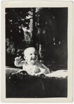 |
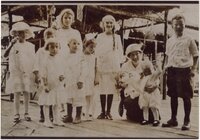
Lees Family [03] | P0005 C. Lowell Lees Photograph Collection | P0005n06_25_003 |
| 152 |
 |
Lees Family [04] | P0005 C. Lowell Lees Photograph Collection | P0005n06_25_004 tif; P0005n06_25_004b.tif |
| 153 |
 |
Lees Family [05] | P0005 C. Lowell Lees Photograph Collection | P0005n06_25_005 |
| 154 |
 |
Lees Family [06] | P0005 C. Lowell Lees Photograph Collection | P0005n06_25_006 |
| 155 |
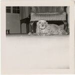 |
Dog [01] | P0005 C. Lowell Lees Photograph Collection | P0005n06_25_009 |
| 156 |
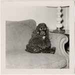 |
Dog [02] | P0005 C. Lowell Lees Photograph Collection | P0005n06_25_010 |
| 157 |
 |
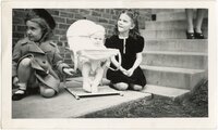
Lees Family [11] | P0005 C. Lowell Lees Photograph Collection | P0005n06_25_014 |
| 158 |
 |
Lees Family, unidentified woman | P0005 C. Lowell Lees Photograph Collection | P0005n06_25_016.tif; P0005n06_25_016a.tif |
| 159 |
 |
Augustus P. Hardy | P0008 Mark A. Pendleton Photograph Collection | P0008n01_09_075 |
| 160 |
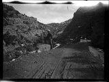 |
Little Creek Canyon road | P0008 Mark A. Pendleton Photograph Collection | P0008n01_10_090 |
| 161 |
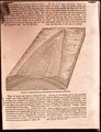 |
Generalized diagram showing relations of the formations near Silver Reef | P0008 Mark A. Pendleton Photograph Collection | P0008n01_10_094 |
| 162 |
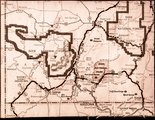 |
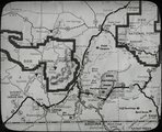
Map of southwestern Utah | P0008 Mark A. Pendleton Photograph Collection | P0008n01_10_095 |
| 163 |
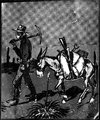 |
Illustration of a miner and his pack mule | P0008 Mark A. Pendleton Photograph Collection | P0008n01_10_096 |
| 164 |
 |
Map of southwestern Utah | P0008 Mark A. Pendleton Photograph Collection | P0008n01_11_097 |
| 165 |
 |
Herbert E. Gregory Book 10: San Juan, Zion, Capitol Reef, 1915-1938 | P0013 Herbert E. Gregory Photograph Collection | P0013n10 |
| 166 |
 |
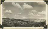
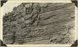
Carmel formation, Kanab Creek near mouth of Sink Canyon. Kane County, Utah, 1938. | P0013 Herbert E. Gregory Photograph Collection | P0013n10_225_2493 |
| 167 |
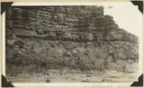
 |
Carmel limestone overlain by later Jurassic and Cretaceous beds, Flume Canyon, near Glendale. Kane County, Utah, 1938. | P0013 Herbert E. Gregory Photograph Collection | P0013n10_225_2494 |
| 168 |
 |
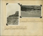
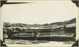
View looking east across "The Cove," near Orderville: foreground, topmost Jurassic and Tropic formation; distance, Elkheart Cliffs, Navajo capped by Carmel. Kane County, Utah, 1938. | P0013 Herbert E. Gregory Photograph Collection | P0013n10_226_2495 |
| 169 |
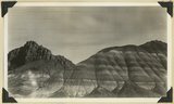
 |
Windsor formation, banded sandstone, Dakota at top. Muddy Brook. Kane County, Utah, 1938. | P0013 Herbert E. Gregory Photograph Collection | P0013n10_226_2496 |
| 170 |
 |
Windsor formation just below Dakota shown at top, branch of Muddy Brook. Kane County, Utah, 1938. | P0013 Herbert E. Gregory Photograph Collection | P0013n10_227_2497 |
| 171 |
 |
Limestone near base of Timpoweap member of the Moenkopi formation, Alkali Wash. Washington County, Utah, 1938. | P0013 Herbert E. Gregory Photograph Collection | P0013n10_229_2498 |
| 172 |
 |
Chinle formation, upper part; Paria Canyon 1± mile above mouth of Kitchen Canyon, Kane County, Utah, 1938. | P0013 Herbert E. Gregory Photograph Collection | P0013n10_230_2499 |
| 173 |
 |
Chinle formation,upper part; Paria Canyon, viewed 1/2± miles along strike. | P0013 Herbert E. Gregory Photograph Collection | P0013n10_231_2500 |
| 174 |
 |
Chinle formation: Petrified Forest member capped by thick sandstone beds, Paria Canyon. Kane County, Utah, 1938. | P0013 Herbert E. Gregory Photograph Collection | P0013n10_231_2501 |
| 175 |
 |
Contact Wingate and Kayenta formation, branch of Kitchen Canyon east of White Cone, Kane County, Utah, 1938. | P0013 Herbert E. Gregory Photograph Collection | P0013n10_232_2502 |