Over 70,000 photos covering a variety of topics from Marriott Library Special Collections
TO
| Title | Collection Number And Name | Photo Number | ||
|---|---|---|---|---|
| 176 |
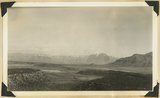 |
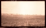
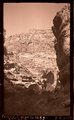
View looking across valley of Little Creek. Shinarump capped cliffs along stream. Smithsonian Butte (left). Navajo Cliffs of Zion Park north across Virgin River. Washington County, Utah, 1937. | P0013 Herbert E. Gregory Photograph Collection | P0013n10_173_2389 |
| 177 |
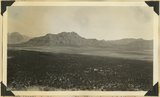 |
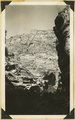
Looking across Big Plains toward Smithsonian Butte (middle background), West Temple (upper right). Foreground forested east slope of Little Creek Mountain, Shinarump; middle distance, dry farm lands on Chinle strata. Washington County, Utah, 1937. | P0013 Herbert E. Gregory Photograph Collection | P0013n10_173_2390 |
| 178 |
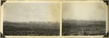 |
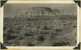
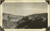
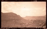
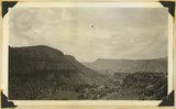
Block mesas from the south, panorama. | P0013 Herbert E. Gregory Photograph Collection | P0013n10_174_2391 |
| 179 |
 |
Block mesas from south, panorama. | P0013 Herbert E. Gregory Photograph Collection | P0013n10_174_2391A |
| 180 |
 |
Block mesas from south, panorama. | P0013 Herbert E. Gregory Photograph Collection | P0013n10_174_2391B |
| 181 |
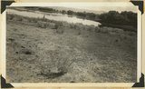 |
Flax Lake, one of five in landslide northeast of Glendale. Foreground floor of once larger lake. Kane County, Utah, 1937. | P0013 Herbert E. Gregory Photograph Collection | P0013n10_175_2392 |
| 182 |
 |
Wingate, Kayenta, Navajo, Kanab Canyon. | P0013 Herbert E. Gregory Photograph Collection | P0013n10_175_2393 |
| 183 |
 |
Tower in Navajo sandstone, outlier of White Cliffs, Kanab Valley, Kane County, Utah, 1937. | P0013 Herbert E. Gregory Photograph Collection | P0013n10_175_2394 |
| 184 |
 |
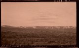
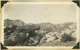
Plateau south of Block Mesas | P0013 Herbert E. Gregory Photograph Collection | P0013n10_176_2395 |
| 185 |
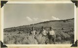 |
Plateau south of Block mesas. Grantham, Stringham, and guide (right), 1937. | P0013 Herbert E. Gregory Photograph Collection | P0013n10_176_2395 |
| 186 |
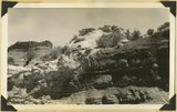 |
Unconformity---Moenkopi (below) and Shinarump (white) in gulch, 2 miles west of Paria village, Kane County, Utah, 1937. | P0013 Herbert E. Gregory Photograph Collection | P0013n10_176_2396 |
| 187 |
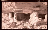 |
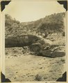
Cliff house, Kaibab Gulch, 1937 | P0013 Herbert E. Gregory Photograph Collection | P0013n10_177_2397 |
| 188 |
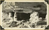 |
Cliff house, Kaibab Gulch, 1937 | P0013 Herbert E. Gregory Photograph Collection | P0013n10_177_2397 |
| 189 |
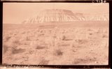 |
Lost Spring Mountain, 1937. | P0013 Herbert E. Gregory Photograph Collection | P0013n10_177_2398 |
| 190 |
 |
Moenkopi capped by Shinarump, Lost Spring Mountain, 1937. | P0013 Herbert E. Gregory Photograph Collection | P0013n10_177_2398 |
| 191 |
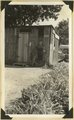 |
Post Office, Virgin City, Utah, 1937. | P0013 Herbert E. Gregory Photograph Collection | P0013n10_178_2399 |
| 192 |
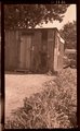 |
Post Office, Virgin, Ut. | P0013 Herbert E. Gregory Photograph Collection | P0013n10_178_2399 |
| 193 |
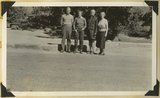 |
Lowery and Gregory, Virgin City, 1937. | P0013 Herbert E. Gregory Photograph Collection | P0013n10_178_2400 |
| 194 |
 |
Fremont River Canyon | P0013 Herbert E. Gregory Photograph Collection | P0013n10_179_2401 |
| 195 |
 |
Wall (Moenkopi) of upper Fremont River canyon at deepest part west of Fruita, Utah, 1937. | P0013 Herbert E. Gregory Photograph Collection | P0013n10_179_2401 |
| 196 |
 |
Fremont River canyon west of Fruita (Moenkopi strata), Wayne County, Utah, 1937. | P0013 Herbert E. Gregory Photograph Collection | P0013n10_179_2402 |
| 197 |
 |
Looking up Fremont River canyon west of Fruita, Miners Mesa in middle distance, Wayne County, Utah, 1937. | P0013 Herbert E. Gregory Photograph Collection | P0013n10_180_2403 |
| 198 |
 |
Freemont Canyon | P0013 Herbert E. Gregory Photograph Collection | P0013n10_180_2404 |
| 199 |
 |
Freemont Canyon just above Fruita, 1937. | P0013 Herbert E. Gregory Photograph Collection | P0013n10_180_2404 |
| 200 |
 |
National (Natural) Bridge, Bridge Canyon 3 miles northeast of Fruita, Wayne County, Utah, 1937. | P0013 Herbert E. Gregory Photograph Collection | P0013n10_181_2405 |