|
|
Title | Collection Number And Name | Photo Number |
| 26 |
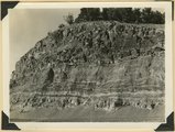 |
Contact Carmel limestone (top) and Navajo (bottom), between them calcareous and argillaceous shales. Kane County, UT | P0013 Herbert E. Gregory Photograph Collection | P0013n11_008_2539 |
| 27 |
 |
Lava flow over Navajo sandstone, near Pine Springs, Kolob Terrace. Washington County, UT | P0013 Herbert E. Gregory Photograph Collection | P0013n11_009_2540 |
| 28 |
 |
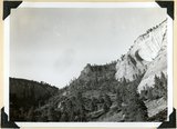
Wingate, Kayenta, and Navajo. Kanab Canyon 2+ miles above junction of Three Lakes. Kane County, UT | P0013 Herbert E. Gregory Photograph Collection | P0013n11_009_2541 |
| 29 |
 |
East wall Meadow Brook Canyon, near highway crossing. Carmel limestone (bottom), Entrada, Curtis, Winsor, Dakota (black band, upper left), base of Tropic shales. Kane County, UT | P0013 Herbert E. Gregory Photograph Collection | P0013n11_010_2542 |
| 30 |
 |
Navajo sandstone, above it (offset) Temple Cap member projected by Carmel limestone. View from base of East Temple. Washington County, UT | P0013 Herbert E. Gregory Photograph Collection | P0013n11_011_2543 |
| 31 |
 |
Near west edge of Kolob Terrace, looking northeast across mouth of Coal Creek; tilted rocks at Hurricane fault (middle); Cedar City, lower left. Iron County, UT | P0013 Herbert E. Gregory Photograph Collection | P0013n11_011_2544 |
| 32 |
 |
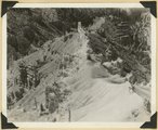
Virgin River in Zion National Park: rising flood from shower on Kolob Terrace | P0013 Herbert E. Gregory Photograph Collection | P0013n11_012_2545 |
| 33 |
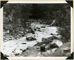 |
Virgin River in Zion National Park: rising flood from shower on Kolob Terrace | P0013 Herbert E. Gregory Photograph Collection | P0013n11_013_2546 |
| 34 |
 |
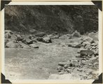
Virgin River in Zion National Park: flood stage | P0013 Herbert E. Gregory Photograph Collection | P0013n11_013_2547 |
| 35 |
 |
Virgin River in Zion National Park: flood stage | P0013 Herbert E. Gregory Photograph Collection | P0013n11_014_2548 |
| 36 |
 |
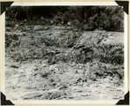
Virgin River in Zion National Park: erosion of land slide at flood stage | P0013 Herbert E. Gregory Photograph Collection | P0013n11_015_2549 |
| 37 |
 |
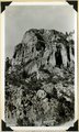
Cave Canyon walls of Navajo sandstone, above them shale and Temple Cap member forms second cliff, capped in turn with Carmel limestone. Zion National Park | P0013 Herbert E. Gregory Photograph Collection | P0013n11_027_2567 |
| 38 |
 |
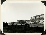
Smithsonian Butte from north base. Chinle, including Springdale member (middle ledge), Wingate? and Kayenta?, Navajo top. Washington County, UT | P0013 Herbert E. Gregory Photograph Collection | P0013n11_028_2568 |
| 39 |
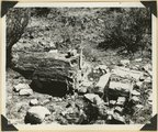 |
Petrified log near base of Chinle, north of Rockville. Zion National Park | P0013 Herbert E. Gregory Photograph Collection | P0013n11_028_2569 |
| 40 |
 |
Sevier fault in gully east of Mt. Carmel Junction. Tropic shale, rounded hills (left); Navajo sandstone in fracture zone (right). Kane County, UT | P0013 Herbert E. Gregory Photograph Collection | P0013n11_029_2570 |
| 41 |
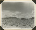 |
Harrisburg Dome near Leeds. Moenkopi and Shinarump strata. Washington County, UT | P0013 Herbert E. Gregory Photograph Collection | P0013n11_029_2571 |
| 42 |
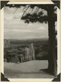 |
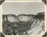
View southeast from Little Bryce Point across Paria amphitheater, pinnacles of Wasatch limestone; upturned edges Navajo sandstone (in distance). Bryce Canyon National Park | P0013 Herbert E. Gregory Photograph Collection | P0013n11_030_2572 |
| 43 |
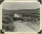 |
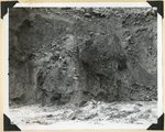
Valley on Paunsaugunt Plateau. Erosion control dam destroyed by torrential shower, 2.30 inches in 20 minutes. Bryce Canyon National Park | P0013 Herbert E. Gregory Photograph Collection | P0013n11_030_2573 |
| 44 |
 |
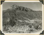
North Rim of canyon, Wasatch limestone. Iron Mountain in distance west. Cedar Breaks National Monument | P0013 Herbert E. Gregory Photograph Collection | P0013n11_031_2574 |
| 45 |
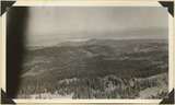 |
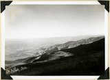
Panorama northwest of Brian Head, Markagunt Plateau. Glacial topography foreground; Wasatch formation (middle distance); Little Salt Lake in valley beyond Hurricane Cliffs. Iron County, UT | P0013 Herbert E. Gregory Photograph Collection | P0013n11_031_2575 |
| 46 |
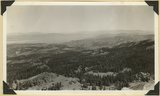 |
Panorama northwest of Brian Head, Markagunt Plateau. Glacial topography foreground; Wasatch formation (middle distance); Little Salt Lake in valley beyond Hurricane Cliffs. Iron County, UT | P0013 Herbert E. Gregory Photograph Collection | P0013n11_032_2576 |
| 47 |
 |
Lava cap on Straight Cliffs formation foot of dugway in Cedar Canyon. Iron County, UT | P0013 Herbert E. Gregory Photograph Collection | P0013n11_033_2577 |
| 48 |
 |
Fault on Rim Point Wasatch formation. Cedar Break National Monument | P0013 Herbert E. Gregory Photograph Collection | P0013n11_033_2578 |
| 49 |
 |
Spur on wall of canyon. Wasatch limestone. Cedar Breaks National Monument | P0013 Herbert E. Gregory Photograph Collection | P0013n11_034_2579 |
| 50 |
 |
Solution channels in Wingate sandstone, Capitol Gorge. Wayne County, UT | P0013 Herbert E. Gregory Photograph Collection | P0013n11_035_2582 |