|
|
Title | Collection Number And Name | Photo Number |
| 1 |
 |
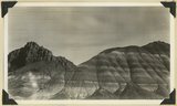
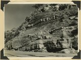
Carmel formation, Kanab Creek near mouth of Sink Canyon. Kane County, Utah, 1938. | P0013 Herbert E. Gregory Photograph Collection | P0013n10_225_2493 |
| 2 |
 |
Carmel limestone overlain by later Jurassic and Cretaceous beds, Flume Canyon, near Glendale. Kane County, Utah, 1938. | P0013 Herbert E. Gregory Photograph Collection | P0013n10_225_2494 |
| 3 |
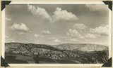 |
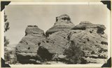
View looking east across "The Cove," near Orderville: foreground, topmost Jurassic and Tropic formation; distance, Elkheart Cliffs, Navajo capped by Carmel. Kane County, Utah, 1938. | P0013 Herbert E. Gregory Photograph Collection | P0013n10_226_2495 |
| 4 |
 |
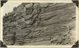
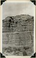
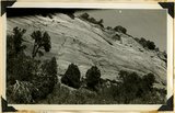
Windsor formation, banded sandstone, Dakota at top. Muddy Brook. Kane County, Utah, 1938. | P0013 Herbert E. Gregory Photograph Collection | P0013n10_226_2496 |
| 5 |
 |
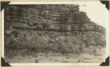
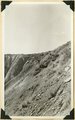
Windsor formation just below Dakota shown at top, branch of Muddy Brook. Kane County, Utah, 1938. | P0013 Herbert E. Gregory Photograph Collection | P0013n10_227_2497 |
| 6 |
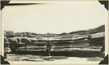 |
Limestone near base of Timpoweap member of the Moenkopi formation, Alkali Wash. Washington County, Utah, 1938. | P0013 Herbert E. Gregory Photograph Collection | P0013n10_229_2498 |
| 7 |
 |
Chinle formation, upper part; Paria Canyon 1± mile above mouth of Kitchen Canyon, Kane County, Utah, 1938. | P0013 Herbert E. Gregory Photograph Collection | P0013n10_230_2499 |
| 8 |
 |
Chinle formation,upper part; Paria Canyon, viewed 1/2± miles along strike. | P0013 Herbert E. Gregory Photograph Collection | P0013n10_231_2500 |
| 9 |
 |
Chinle formation: Petrified Forest member capped by thick sandstone beds, Paria Canyon. Kane County, Utah, 1938. | P0013 Herbert E. Gregory Photograph Collection | P0013n10_231_2501 |
| 10 |
 |
Contact Wingate and Kayenta formation, branch of Kitchen Canyon east of White Cone, Kane County, Utah, 1938. | P0013 Herbert E. Gregory Photograph Collection | P0013n10_232_2502 |
| 11 |
 |
Wingate sandstone, head of the upper south branch of Kitchen Canyon, east of White Cone. Kane County, Utah, 1938. | P0013 Herbert E. Gregory Photograph Collection | P0013n10_232_2503 |
| 12 |
 |
Basalt flow from Bald Knob Volcano, upper Johnson Canyon. Kane County, Utah, 1938. | P0013 Herbert E. Gregory Photograph Collection | P0013n10_233_2504 |
| 13 |
 |
Windsor formation capped by Dakota on Alton-Johnson road, 3± miles east of Sink Creek, Kane County, Utah, 1938. | P0013 Herbert E. Gregory Photograph Collection | P0013n10_234_2505 |
| 14 |
 |
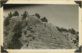
Massive sandstone of Wahweap (?) formation, Tenney Canyon, Kane County, Utah, 1938. | P0013 Herbert E. Gregory Photograph Collection | P0013n10_236_2506 |
| 15 |
 |
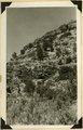
Same as 1165 [White bed in Kaiparowits formation (bed 38 of measured section), Tenny Canyon, Kane County, UT 1938] | P0013 Herbert E. Gregory Photograph Collection | P0013n11_001_2527 |
| 16 |
 |
Same as 1167 [Moenkopi formation 2± miles west of Paria on old Kanab Trail. Kane County, UT, 1938] | P0013 Herbert E. Gregory Photograph Collection | P0013n11_001_2528 |
| 17 |
 |
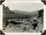
Fault. Wasatch Tertiary on left (west); Cretaceous on right; head of Paria Canyon. Garfield County, UT, 1938 | P0013 Herbert E. Gregory Photograph Collection | P0013n11_002_2529 |
| 18 |
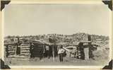 |
Headquarters of old Kitchen Ranch, Kitchen Canyon. Kane County, UT, 1938. Bronson Stringham standing | P0013 Herbert E. Gregory Photograph Collection | P0013n11_003_2530 |
| 19 |
 |
Entrada sandstone overlain by the heavy gypsum bed of the Curtis formation. Carmel limestone at left brought to level of Entrada by a fault, on Highway 15 near junction with Highway 89. Kane County, UT, 1938 | P0013 Herbert E. Gregory Photograph Collection | P0013n11_003_2531 |
| 20 |
 |
Temple Cap member of the Navajo formation overlain by Carmel limestone, head of Parunuweap Canyon. Kane County, UT, 1938 | P0013 Herbert E. Gregory Photograph Collection | P0013n11_004_2532 |
| 21 |
 |
Temple Cap member of the Navajo formation near east entrance to Zion National Park, Kane County, UT, 1938 | P0013 Herbert E. Gregory Photograph Collection | P0013n11_004_2533 |
| 22 |
 |
East Temple. Buttress forms wall of Pine Creek; Navajo sandstone; top, Temple cap member. Zion National Park, 1938 | P0013 Herbert E. Gregory Photograph Collection | P0013n11_005_2534 |
| 23 |
 |
Bridge Mountain. Navajo sandstone; view south base of East Temple across Pine Creek; Tunnel Road lower right. Zion National Park, 1938 | P0013 Herbert E. Gregory Photograph Collection | P0013n11_005_2535 |
| 24 |
 |
Part of Chinle formation above Springdale member; sandstone, shales and lime conglomerates. Pine Valley. Zion National Park, 1938 | P0013 Herbert E. Gregory Photograph Collection | P0013n11_006_2536 |
| 25 |
 |
Site of Springdale, Virgin River Valley, below mouth of Zion Canyon. At left, the Watchman. Navajo sandstone, underlaid by Chinle: middle cliff is Springdale member. Washington County, UT | P0013 Herbert E. Gregory Photograph Collection | P0013n11_007_2538 |