Home
Browse
Ask Us
Chat
Harmful Language Statement
Log in
Photo Archives
Advanced Search
About
Over 70,000 photos covering a variety of topics from Marriott Library Special Collections
Year
1915
1916
1917
1918
1919
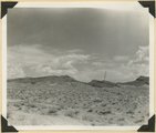
1920
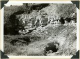
1921
1922
1923
1924
1925
1926
1927
1928
1929
1930
1931
1932
1933
1934
1935
1936
1937
1938
1939
1940
1941
1942
TO
1915
1916
1917
1918
1919
1920
1921
1922
1923
1924
1925
1926
1927
1928
1929
1930
1931
1932
1933
1934
1935
1936
1937
1938
1939
1940
1941
1942
Type
Image
58
Format
image/jpeg
56
application/pdf
2
Collection
Photo Archives
58
Filters:
Collection Name:
"Herbert E. Gregory"
Date:
"1938"
1
-
25
of
58
<
1
2
3
>
Gallery view
Number of results to display per page
10
25
50
100
200
Sort by Relevance
Sort by Title A-Z
Sort by Title Z-A
Sort by Date Ascending
Sort by Date Descending
Sort by Last Modified Ascending
Sort by Last Modified Descending
Title
Date
Type
1
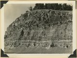
Basalt flow from Bald Knob Volcano, upper Johnson Canyon. Kane County, Utah, 1938.
1938
Image
2
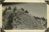
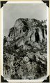
Bridge Mountain. Navajo sandstone; view south base of East Temple across Pine Creek; Tunnel Road lower right. Zion National Park, 1938
1938
Image
3
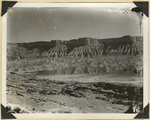
Carmel formation, Kanab Creek near mouth of Sink Canyon. Kane County, Utah, 1938.
1938
Image
4
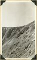
Carmel limestone overlain by later Jurassic and Cretaceous beds, Flume Canyon, near Glendale. Kane County, Utah, 1938.
1938
Image
5
Cave Canyon walls of Navajo sandstone, above them shale and Temple Cap member forms second cliff, capped in turn with Carmel limestone. Zion National Park
1937; 1938
Image
6
Chinle formation, upper part; Paria Canyon 1± mile above mouth of Kitchen Canyon, Kane County, Utah, 1938.
1938
Image
7
Chinle formation,upper part; Paria Canyon, viewed 1/2± miles along strike.
1938
Image
8
Chinle formation: Petrified Forest member capped by thick sandstone beds, Paria Canyon. Kane County, Utah, 1938.
1938
Image
9
Contact Carmel limestone (top) and Navajo (bottom), between them calcareous and argillaceous shales. Kane County, UT
1937; 1938
Image
10
Contact Wingate and Kayenta formation, branch of Kitchen Canyon east of White Cone, Kane County, Utah, 1938.
1938
Image
11
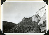
East Temple. Buttress forms wall of Pine Creek; Navajo sandstone; top, Temple cap member. Zion National Park, 1938
1938
Image
12
East wall Meadow Brook Canyon, near highway crossing. Carmel limestone (bottom), Entrada, Curtis, Winsor, Dakota (black band, upper left), base of Tropic shales. Kane County, UT
1937; 1938
Image
13
Entrada sandstone overlain by the heavy gypsum bed of the Curtis formation. Carmel limestone at left brought to level of Entrada by a fault, on Highway 15 near junction with Highway 89. Kane County, UT, 1938
1938
Image
14
Erosion on Mancos shales, branch of Fremont River above Cainesville. Wayne County, UT
1938; 1939
Image
15
Fault on Rim Point Wasatch formation. Cedar Break National Monument
1937; 1938
Image
16
Fault. Wasatch Tertiary on left (west); Cretaceous on right; head of Paria Canyon. Garfield County, UT, 1938
1938
Image
17
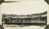
Floor of "sink" in Carmel limestone showing solution channels in bedded rock and opening of underground drainage 3 channel. Near Blue Springs, Kolob Terrace, Washington County, UT, 1938
1938
Image
18
Harrisburg Dome near Leeds. Moenkopi and Shinarump strata. Washington County, UT
1937; 1938
Image
19
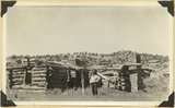
Headquarters of old Kitchen Ranch, Kitchen Canyon. Kane County, UT, 1938. Bronson Stringham standing
1938
Image
20
Herbert E. Gregory Book 10: San Juan, Zion, Capitol Reef, 1915-1938
1915; 1916; 1917; 1918; 1919; 1920; 1921; 1922; 1923; 1924; 1925; 1926; 1927; 1928; 1929; 1930; 1931; 1932; 1933; 1934; 1935; 1936; 1937; 1938
Image
21
Herbert E. Gregory Book 11: Colorado Plateau, 1938-1942
1938; 1939; 1940; 1941; 1942
Image
22
Lava cap on Straight Cliffs formation foot of dugway in Cedar Canyon. Iron County, UT
1937; 1938
Image
23
Lava flow over Navajo sandstone, near Pine Springs, Kolob Terrace. Washington County, UT
1937; 1938
Image
24
Limestone near base of Timpoweap member of the Moenkopi formation, Alkali Wash. Washington County, Utah, 1938.
1938
Image
25
Massive sandstone of Wahweap (?) formation, Tenney Canyon, Kane County, Utah, 1938.
1938
Image
1
-
25
of
58
<
1
2
3
>