|
|
Title | Collection Number And Name | Photo Number |
| 51 |
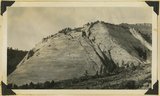 |
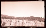
Wingate sandstone, Kanab Canyon, 1936. | P0013 Herbert E. Gregory Photograph Collection | P0013n10_141_2331 |
| 52 |
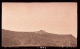 |
E. Kanab | P0013 Herbert E. Gregory Photograph Collection | P0013n10_142_2332 |
| 53 |
 |
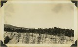
Top of Chinle, Wingate in background, E. Kanab, 1936. | P0013 Herbert E. Gregory Photograph Collection | P0013n10_142_2332 |
| 54 |
 |
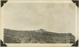
Kolob Plateau | P0013 Herbert E. Gregory Photograph Collection | P0013n10_142_2333 |
| 55 |
 |
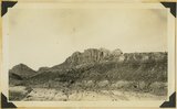
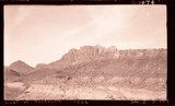
Kolob plateau, general surface. Pink cliffs in background, 1936. | P0013 Herbert E. Gregory Photograph Collection | P0013n10_142_2333 |
| 56 |
 |
Paria Village | P0013 Herbert E. Gregory Photograph Collection | P0013n10_143_2334 |
| 57 |
 |
Unconformity Moenkopi-Shinarump west Paria village, 1936. | P0013 Herbert E. Gregory Photograph Collection | P0013n10_143_2334 |
| 58 |
 |
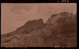
Upper Moenkopi Shanabkaib member at base showing sandstone ledge, Shinarump at top, Rockville, Washington County, Utah, 1936. | P0013 Herbert E. Gregory Photograph Collection | P0013n10_143_2335 |
| 59 |
 |
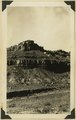
Moenkopi (upper two-thirds) overlaid by Shinarump 2 miles west of Rockville, Washington County, Utah, 1936. | P0013 Herbert E. Gregory Photograph Collection | P0013n10_143_2336 |
| 60 |
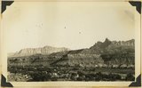 |
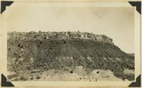
Looking southeast across Rockville, Moenkopi (at river), Shinarump (mesa caps), Chinle (broken slopes), Navajo (top), showing Eagle Crag (right), and South Mountain (left), Washington County, Utah, 1936. | P0013 Herbert E. Gregory Photograph Collection | P0013n10_144_2337 |
| 61 |
 |
Navajo sandstone, branch of Parashant Wash north of Cane Beds, Arizona. Kane County, Utah, 1936. | P0013 Herbert E. Gregory Photograph Collection | P0013n10_145_2338 |
| 62 |
 |
Panorama, Harris Mountain from south. All Navajo except for Carmel limestone on top highest mesas. Kane County, Utah, 1936. | P0013 Herbert E. Gregory Photograph Collection | P0013n10_145_2339 |
| 63 |
 |
Elephant Gap in Harris Mountain from Arizona-Utah line north of Cane beds. Navajo sandstone, foreground, and cliffs, Carmel caps, Kane County, Utah, 1936. | P0013 Herbert E. Gregory Photograph Collection | P0013n10_146_2340 |
| 64 |
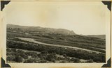 |
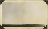
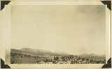
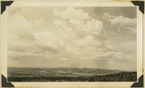
Looking east across Sevier River near Hatch River terraces in middle distance, "Pink Cliffs" (Wasatch) in background bounded by Sevier fault. Garfield County, Utah, 1936. | P0013 Herbert E. Gregory Photograph Collection | P0013n10_147_2341 |
| 65 |
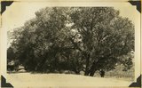 |
Cottonwood trees partly buried in drifted sands, Short Creek, Arizona, 1936. | P0013 Herbert E. Gregory Photograph Collection | P0013n10_148_2342 |
| 66 |
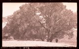 |
Short Creek, Ariz., Cottonwood trees in sand | P0013 Herbert E. Gregory Photograph Collection | P0013n10_148_2342 |
| 67 |
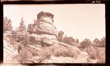 |
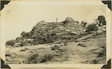
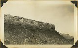
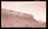
Sandstone, head of Cave Wash, 1936 | P0013 Herbert E. Gregory Photograph Collection | P0013n10_148_illus1070 |
| 68 |
 |
Carmel Flume (dry) Canyon, N.E. Glendale | P0013 Herbert E. Gregory Photograph Collection | P0013n10_149_2343 |
| 69 |
 |
Carmel Flume (dry) Canyon, N.E. Glendale. 1936. | P0013 Herbert E. Gregory Photograph Collection | P0013n10_149_2343 |
| 70 |
 |
Upper Moenkopi capped by Shinarump west of Rockville, 1936. | P0013 Herbert E. Gregory Photograph Collection | P0013n10_149_2344 |
| 71 |
 |
West of Rockville, 1936 | P0013 Herbert E. Gregory Photograph Collection | P0013n10_149_2344 |
| 72 |
 |
Looking northwest across Parunuweap east of Mt. Carmel, Cretaceous in middle ground, Pink Cliffs in distance, 1936. | P0013 Herbert E. Gregory Photograph Collection | P0013n10_150_2345 |
| 73 |
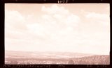 |
N.W. across Parunuweap, 1936 | P0013 Herbert E. Gregory Photograph Collection | P0013n10_150_2345 |
| 74 |
 |
Moenkopi and Shinarump, Rockville, 1936. | P0013 Herbert E. Gregory Photograph Collection | P0013n10_150_2346 |
| 75 |
 |
Rockville 1936 | P0013 Herbert E. Gregory Photograph Collection | P0013n10_150_2346 |