Home
Browse
Ask Us
Chat
Harmful Language Statement
Log in
Advanced Search
Year
1920
1921
1922
1923
1924
1925
1926
1927
1928
1929
1930
1931
1932
1933
1934
1935
1936
1937
1938
1939
1940
1941
1942
1943
1944
1945
1946
1947
1948
1949
1950
1951
1952
1953
1954
1955
1956
1957
1958
1959
1960
1961
1962
1963
1964
1965
1966
1967
1968
1969
1970
1971
1972
1973
1974
1975
1976
1977
1978
1979
1980
1981
1982
1983
1984
1985
1986
1987
1988
1989
1990
1991
1992
1993
1994
1995
1996
1997
1998
1999
TO
1920
1921
1922
1923
1924
1925
1926
1927
1928
1929
1930
1931
1932
1933
1934
1935
1936
1937
1938
1939
1940
1941
1942
1943
1944
1945
1946
1947
1948
1949
1950
1951
1952
1953
1954
1955
1956
1957
1958
1959
1960
1961
1962
1963
1964
1965
1966
1967
1968
1969
1970
1971
1972
1973
1974
1975
1976
1977
1978
1979
1980
1981
1982
1983
1984
1985
1986
1987
1988
1989
1990
1991
1992
1993
1994
1995
1996
1997
1998
1999
Type
Image
739
Text
1
Format
image/jpeg
738
application/pdf
1
Collection
Peoples of Utah Revisited
31
Photo Archives
330
Ski and Snow Sports Archives
134
University Archival Photographs (P0305)
19
Utah River Running Photo Archives
225
Filters:
Genre:
"color slides"
Type:
"Image"
201
-
225
of
739
<
4
5
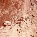
6
7
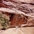
8
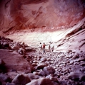
9
10
11
12
13
>
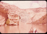
Gallery view
Number of results to display per page
10
25
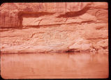
50
100
200
Sort by Relevance
Sort by Title A-Z
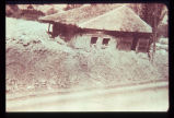
Sort by Title Z-A
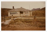
Sort by Date Ascending
Sort by Date Descending
Sort by Last Modified Ascending
Sort by Last Modified Descending
Title
Date
Type
Setname
201
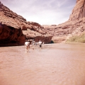
Group hiking through a narrow canyon on their way to Rainbow Bridge.
1962-05
Image
uum_map_rr
202
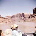
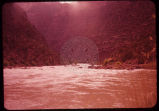
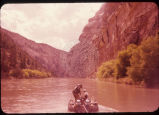
Group of people boating down the Colorado River in Glen Canyon.
1962-05
Image
uum_map_rr
203
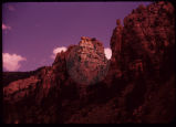
Group of people gathered at the base of a large rock wall.
1962-05
Image
uum_map_rr
204
Group of people gathered at the base of a large rock wall.
1962-05
Image
uum_map_rr
205
Group of people hiking along the base of a large rock wall.
1962-05
Image
uum_map_rr
206
Group of people hiking through a side canyon in Glen Canyon.
1962-05
Image
uum_map_rr
207
Group of people loading their boats.
1962-05
Image
uum_map_rr
208
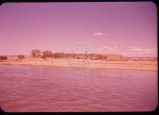
Group of people walking along a beach in Glen Canyon.
1962-05
Image
uum_map_rr
209
Group of people walking along a beach in Glen Canyon.
1962-05
Image
uum_map_rr
210
Group of skiers talking together, a ski lift can be seen in the background.
1960; 1961; 1962; 1963; 1964; 1965; 1966; 1967; 1968; 1969
Image
uum_map_usa
211
Hebgen Fault scarp near Cabin Creek, aftermath of the 1959 Montana earthquake. Note tilt of trees and the recovery of vegetation over the scarp in only 11 years (photo taken August 1970).
1970-08
Image
uum_map
212
Hell's Half Mile. 6-15-55
1955-06-15
Image
uum_map_rr
213
High rustler during the summer before the cat track was made.
1930; 1931; 1932; 1933; 1934; 1935; 1936; 1937; 1938; 1939; 1940; 1941; 1942; 1943; 1944; 1945; 1946; 1947; 1948; 1949; 1950; 1951; 1952; 1953; 1954; 1955; 1956; 1957; 1958; 1959; 1960; 1961; 1962; 1963; 1964; 1965; 1966; 1967; 1968; 1969; 1970; 1971; 1972; 1973; 1974; 1975; 1976; 1977; 1978; 1979
Image
uum_map_usa
214
Hillside subdivision in landslide terrain. Terrain in background has slid in the past. Instrument for measuring ground displacement is housed in box in foreground. White rain gage sits atop instrument housing.
Image
uum_map
215
Holmes Ranch on Green River. Afternoon. 6-11-55
1955-06-11
Image
uum_map_rr
216
Horseshoe Canyon. 6-12-55
1955-06-12
Image
uum_map_rr
217
Horseshoe Canyon. 6-12-55
1955-06-12
Image
uum_map_rr
218
Horseshoe Canyon. 6-12-55
1955-06-12
Image
uum_map_rr
219
Horseshoe Canyon. 6-12-55
1955-06-12
Image
uum_map_rr
220
Horseshoe Canyon. 6-12-55
1955-06-12
Image
uum_map_rr
221
House carried on mud-flow from Davis Creek, Davis County. Historic photo, 1930. Debris covered the highway to a depth of about 6 feet.
1930
Image
uum_map
222
Hoytsville Schoolhouse images
1970
Image
dha_pour
223
Hydrograph depicting flow for the year 1945 of Utah's second largest spring, Swan Creek Spring, west of Bear Lake in northern Utah. Note the fluctuation in flow from April to September. Note also rapid response to spring snowmelt (April and May) and rainfall (June and July). The rock from which the spring issues (aquifer) is limestone. The graph illustrates the importance of controlling development on limestone terrain.
Image
uum_map
224
In the same house; the ceiling is clearly distressed.
Image
uum_map
225
Incipient landslide failure on subdivision road. Note characteristic arcuate configuration of ground surface, also patching along crack.
Image
uum_map
201
-
225
of
739
<
4
5
6
7
8
9
10
11
12
13
>