Home
Browse
Ask Us
Chat
Harmful Language Statement
Log in
Advanced Search
Year
1920
1921
1922
1923
1924
1925
1926
1927
1928
1929
1930
1931
1932
1933
1934
1935
1936
1937
1938
1939
1940
1941
1942
1943
1944
1945
1946
1947
1948
1949
1950
1951
1952
1953
1954
1955
1956
1957
1958
1959
1960
1961
1962
1963
1964
1965
1966
1967
1968
1969
1970
1971
1972
1973
1974
1975
1976
1977
1978
1979
1980
1981
1982
1983
1984
1985
1986
1987
1988
1989
1990
1991
1992
1993
1994
1995
1996
1997
1998
1999
TO
1920
1921
1922
1923
1924
1925
1926
1927
1928
1929
1930
1931
1932
1933
1934
1935
1936
1937
1938
1939
1940
1941
1942
1943
1944
1945
1946
1947
1948
1949
1950
1951
1952
1953
1954
1955
1956
1957
1958
1959
1960
1961
1962
1963
1964
1965
1966
1967
1968
1969
1970
1971
1972
1973
1974
1975
1976
1977
1978
1979
1980
1981
1982
1983
1984
1985
1986
1987
1988
1989
1990
1991
1992
1993
1994
1995
1996
1997
1998
1999
Type
Image
739
Text
1
Format
image/jpeg
738
application/pdf
1
Collection
Peoples of Utah Revisited
31
Photo Archives
330
Ski and Snow Sports Archives
134
University Archival Photographs (P0305)
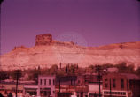
19
Utah River Running Photo Archives
225
Filters:
Genre:
"color slides"
Type:
"Image"
176
-
200
of
739
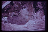
<
3
4
5
6
7
8
9
10
11
12
>
Gallery view
Number of results to display per page
10
25
50
100
200
Sort by Relevance
Sort by Title A-Z
Sort by Title Z-A
Sort by Date Ascending
Sort by Date Descending
Sort by Last Modified Ascending
Sort by Last Modified Descending
Title
Date
Type
Setname
176
From 1st lunch stop. B.F. 6-11-55
1955-06-11
Image
uum_map_rr
177
Front end view of the slide (p1274n030).
Image
uum_map
178
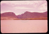
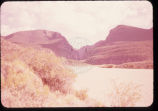
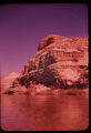
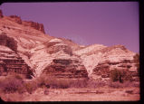
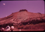
Gate of Ladore [sic] (Lodore). 6-14-55
1955-06-14
Image
uum_map_rr
179
Gate of Ladore [sic] (Lodore). 6-14-55
1955-06-14
Image
uum_map_rr
180
Gate of Ladore [sic] (Lodore). 6-14-55
1955-06-14
Image
uum_map_rr
181
Gate of Ladore [sic] (Lodore). 6-14-55
1955-06-14
Image
uum_map_rr
182
Gate of Ladore [sic] (Lodore). 6-14-55
1955-06-14
Image
uum_map_rr
183
Gate of Ladore [sic] (Lodore). 6-14-55
1955-06-14
Image
uum_map_rr
184
Gate of Ladore [sic] (Lodore). 6-14-55
1955-06-14
Image
uum_map_rr
185
Gate of Ladore [sic] (Lodore). 6-14-55
1955-06-14
Image
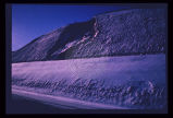
uum_map_rr
186
Geologic map of Bear Lake showing the geologic hazards in the area. The active Bear Lake fault zone is outlined in yellow, and landslides in red. Hazardous areas must be given due consideration by planning authorities.
Image
uum_map
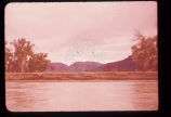
187
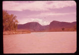
Green River, Wyo. 6-10-55
1955-06-10
Image
uum_map_rr
188
Green River, Wyo. 6-10-55
1955-06-10
Image
uum_map_rr
189
Green River, Wyo. 6-10-55
1955-06-10
Image
uum_map_rr
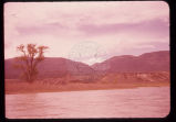
190
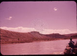
Green River. 1st day. 6-11-55
1955-06-11
Image
uum_map_rr
191
Green River. 1st day. 6-11-55
1955-06-11
Image
uum_map_rr
192
Green River. 1st day. 6-11-55
1955-06-11
Image
uum_map_rr
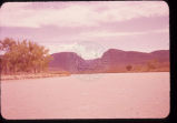
193
Green River. 6-11-55
1955-06-11
Image
uum_map_rr
194
Green River. 6-11-55
1955-06-11
Image
uum_map_rr
195
Green River. 6-11-55
1955-06-11
Image
uum_map_rr
196
Green River. 6-11-55
1955-06-11
Image
uum_map_rr
197
Green River. B.F. 6-11-55
1955-06-11
Image
uum_map_rr
198
Green River. B.F. 6-11-55
1955-06-11
Image
uum_map_rr
199
Ground subsidence leaves this fireplug supported above the sidewalk in downtown Salt Lake City.
Image
uum_map
200
Groundwater, boiling up sand, at depth of a few feet in Sugarhouse, Salt Lake City, revealed by foundation excavation. Water probably arises along East Bench branch of the Wasatch Fault.
Image
uum_map
176
-
200
of
739
<
3
4
5
6
7
8
9
10
11
12
>