| Title | Date | Type | Setname | ||
|---|---|---|---|---|---|
| 276 |
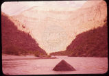 |
Lower Ladore [sic] (Lodore) 6-15-55 | 1955-06-15 | Image | uum_map_rr |
| 277 |
 |
Lower Ladore [sic] (Lodore) Canyon. 6-15-55 | 1955-06-15 | Image | uum_map_rr |
| 278 |
 |
Man hiking up a small river in Glen Canyon. | 1962-05 | Image | uum_map_rr |
| 279 |
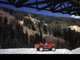 |
Man sitting in a jeep during the summer. Mining facilities, fills and a cleared ski run are seen in the background. | 1960; 1961; 1962; 1963; 1964; 1965; 1966; 1967; 1968; 1969 | Image | uum_map_usa |
| 280 |
 |
Map of Bear Lake showing bottom contours of the lake and depth to bedrock beneath soft valley sediments. The delta-fan areas along the east shore are colored yellow to indicate another hazard. Response of the delta-fan soft sediments to earthquake vibrations is anticipated to be poor, almost certainly causing severe damage to structures built on these level areas. Different earth materials may be expected to behave differently when shaken in an earthquake. The closeness of the contours bounding the delta-fans indicates a steep front for each. Movement of material in an earthquake may be expected to occur towards these steep fronts. | Image | uum_map | |
| 281 |
 |
Map of portion of the Wasatch Front showing the Wasatch Fault Zone in relation to the Salt Lake City aqueduct system (with water system facilities as projected into the 20th Century). Map illustrates severity of the earthquake problem in urban Utah. | Image | uum_map | |
| 282 |
 |
Map of Utah showing the 5 major active fault zones in the state. | Image | uum_map | |
| 283 |
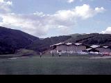 |
Men golfing at a Park City course. | 1960; 1961; 1962; 1963; 1964; 1965; 1966; 1967; 1968; 1969 | Image | uum_map_usa |
| 284 |
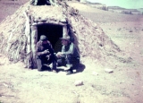 |
Men in front of Indian shelter/home. | 1940; 1941; 1942; 1943; 1944; 1945; 1946; 1947; 1948; 1949; 1950; 1951; 1952; 1953; 1954; 1955; 1956; 1957; 1958; 1959 | Image | uum_map |
| 285 |
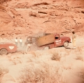 |
Men pushing a car out of a ditch on the way to Hite. | 1962-05 | Image | uum_map_rr |
| 286 |
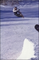 |
Mikey LeBlanc snowboarding at Park City. | 1998 | Image | uum_map_usa |
| 287 |
 |
Minerals. | 1940; 1941; 1942; 1943; 1944; 1945; 1946; 1947; 1948; 1949; 1950; 1951; 1952; 1953; 1954; 1955; 1956; 1957; 1958; 1959 | Image | uum_map |
| 288 |
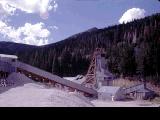 |
Mining facilities at Park City. | 1960; 1961; 1962; 1963; 1964; 1965; 1966; 1967; 1968; 1969 | Image | uum_map_usa |
| 289 |
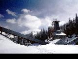 |
Mining facilities which used to be the entrance to the ski lift " Thaynes Shaft." | 1960; 1961; 1962; 1963; 1964; 1965; 1966; 1967; 1968; 1969 | Image | uum_map_usa |
| 290 |
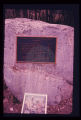 |
Monument to campers who lost their lives in cloudburst flood in Sheep Creek Canyon, in Flaming Gorge National Recreational Area, 1963. Note: boulder on which bronze monument has been placed is striated and polished by glacial action in the ice age. | Image | uum_map | |
| 291 |
 |
Monument Valley | 1940; 1941; 1942; 1943; 1944; 1945; 1946; 1947; 1948; 1949; 1950; 1951; 1952; 1953; 1954; 1955; 1956; 1957; 1958; 1959 | Image | uum_map |
| 292 |
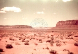 |
Monument Valley, unidentified mesas. | 1940; 1941; 1942; 1943; 1944; 1945; 1946; 1947; 1948; 1949; 1950; 1951; 1952; 1953; 1954; 1955; 1956; 1957; 1958; 1959 | Image | uum_map |
| 293 |
 |
Monument Valley: Big Indian [1] | 1940; 1941; 1942; 1943; 1944; 1945; 1946; 1947; 1948; 1949; 1950; 1951; 1952; 1953; 1954; 1955; 1956; 1957; 1958; 1959 | Image | uum_map |
| 294 |
 |
Monument Valley: Big Indian [2] | 1940; 1941; 1942; 1943; 1944; 1945; 1946; 1947; 1948; 1949; 1950; 1951; 1952; 1953; 1954; 1955; 1956; 1957; 1958; 1959 | Image | uum_map |
| 295 |
 |
Monument Valley: Big Indian [3] | 1940; 1941; 1942; 1943; 1944; 1945; 1946; 1947; 1948; 1949; 1950; 1951; 1952; 1953; 1954; 1955; 1956; 1957; 1958; 1959 | Image | uum_map |
| 296 |
 |
Monument Valley: Castle Rock [1] | 1940; 1941; 1942; 1943; 1944; 1945; 1946; 1947; 1948; 1949; 1950; 1951; 1952; 1953; 1954; 1955; 1956; 1957; 1958; 1959 | Image | uum_map |
| 297 |
 |
Monument Valley: Castle Rock [2 | 1940; 1941; 1942; 1943; 1944; 1945; 1946; 1947; 1948; 1949; 1950; 1951; 1952; 1953; 1954; 1955; 1956; 1957; 1958; 1959 | Image | uum_map |
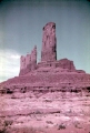
| 298 |
 |
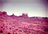
Monument Valley: Castle Rock and Saddleback | 1940; 1941; 1942; 1943; 1944; 1945; 1946; 1947; 1948; 1949; 1950; 1951; 1952; 1953; 1954; 1955; 1956; 1957; 1958; 1959 | Image | uum_map |
| 299 |
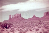 |
Monument Valley: Castle Rock and Stagecoach [1] | 1940; 1941; 1942; 1943; 1944; 1945; 1946; 1947; 1948; 1949; 1950; 1951; 1952; 1953; 1954; 1955; 1956; 1957; 1958; 1959 | Image | uum_map |
| 300 |
 |
Monument Valley: Castle Rock and Stagecoach [2] | 1940; 1941; 1942; 1943; 1944; 1945; 1946; 1947; 1948; 1949; 1950; 1951; 1952; 1953; 1954; 1955; 1956; 1957; 1958; 1959 | Image | uum_map |