Home
Browse
Ask Us
Chat
Harmful Language Statement
Log in
Photo Archives
Advanced Search
About
Over 70,000 photos covering a variety of topics from Marriott Library Special Collections
Year
1845
1846
1847
1848
1849
1850
1851
1852
1853
1854
1855
1856
1857
1858
1859
1860
1861
1862
1863
1864
1865
1866
1867
1868
1869
1870
1871
1872
1873
1874
1875
1876
1877
1878
1879
1880
1881
1882
1883
1884
1885
1886
1887
1888
1889
1890
1891
1892
1893
1894
1895
1896
1897
1898
1899
1900
1901
1902
1903
1904
1905
1906
1907
1908
1909
1910
1911
1912
1913
1914
1915
1916
1917
1918
1919
1920
1921
1922
1923
1924
1925
1926
1927
1928
1929
1930
1931
1932
1933
1934
1935
1936
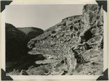
1937
1938
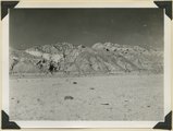
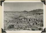
1939
1940
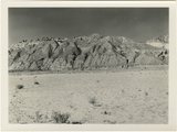
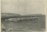
1941
1942
1943
1944
1945
1946
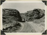
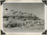
1947
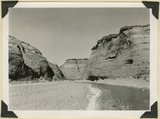
1948
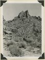
1949
1950
1951
1952
1953
1954
1955
1956
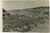
1957
1958
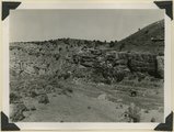
1959
1960
1961
1962
1963
1964
1965
1966
1967
1968
1969
1970
1971
1972
1973
1974
1975
1976
1977
1978
1979
1980
1981
1982
1983
1984
1985
1986
1987
1988
1989
1990
1991
1992
1993
1994
1995
1996
1997
1998
1999
2000
2001
2002
2003
2004
2005
TO
1845
1846
1847
1848
1849
1850
1851
1852
1853
1854
1855
1856
1857
1858
1859
1860
1861
1862
1863
1864
1865
1866
1867
1868
1869
1870
1871
1872
1873
1874
1875
1876
1877
1878
1879
1880
1881
1882
1883
1884
1885
1886
1887
1888
1889
1890
1891
1892
1893
1894
1895
1896
1897
1898
1899
1900
1901
1902
1903
1904
1905
1906
1907
1908
1909
1910
1911
1912
1913
1914
1915
1916
1917
1918
1919
1920
1921
1922
1923
1924
1925
1926
1927
1928
1929
1930
1931
1932
1933
1934
1935
1936
1937
1938
1939
1940
1941
1942
1943
1944
1945
1946
1947
1948
1949
1950
1951
1952
1953
1954
1955
1956
1957
1958
1959
1960
1961
1962
1963
1964
1965
1966
1967
1968
1969
1970
1971
1972
1973
1974
1975
1976
1977
1978
1979
1980
1981
1982
1983
1984
1985
1986
1987
1988
1989
1990
1991
1992
1993
1994
1995
1996
1997
1998
1999
2000
2001
2002
2003
2004
2005
Type
Image
3,443
Image/StillImage
1,795
Format
image/jpeg
5,286
application/pdf
1,170
Collection Name
Olive Woolley Burt
840
Everett Ruess Family
702
Charles Kelly
599
EIMCO Photograph Collection
250
Wallace and Mary Doi
222
The Institute of the American West photograph collection, 1886-1985
213
Leo Leonard
210
Shipler Studio
179
Sumi Niiya Takemoto
176
Reo Robbins
169
Ray Yourdon
155
Deseret Livestock Company
147
Topaz, Utah and Hispanics in Utah films, 1940-1990
141
Wallace Stegner
111
Emigration Canyon History
109
J. Willard and Alice Sheets Marriott
107
Herbert E. Gregory
103
Maud May Babcock
98
Albion W. and Agnes Sharp Caine
90
Mining Photograph Collection
83
C. Lowell Lees
74
Ruth Harwood
73
Ivy Baker Priest
68
Marriner S. Eccles
68
Camp Kearns
61
Charles Neal
60
Kennecott Copper Corporation
58
Utah Schools photograph collection
58
Rocky Mountain Power Company
52
G. Bennet Larson
51
Philo T. Farnsworth
45
Tooele Army Depot
44
Salt Lake City, Utah
39
Faith Terasawa
34
Vern Adix
30
Bingham Canyon
29
Greek Archives
29
Noel Okamoto digital photograph collection
28
American Red Cross
27
Fort Douglas
26
Joe Hill Conference
26
Gosiute Indians
24
Utah Railroads
24
E. A. Taylor
23
McIntyre Ranch
22
Arden R. Gaufin
21
George and Jane Beppu Sakashita
21
Alberta Hunt Nicholson photograph collection
19
LeRoy Robertson photograph collection, 1945-1960
19
Seiko and Sumi Oki Arakaki
19
Marvin J. Bertoch
18
Waldo Wilcox
18
JoAnne C. Swindle photograph collection
16
United States Fuel Corporation
15
Combined Metals Reduction Company
13
Croydon Utah/Devil's Slide Cement Plant
13
George Snell
13
Geraldine Palmer Jones
13
Ivor Sharp
13
Wasatch Mountain Club
13
Alberta Henry
12
Japanese Oral Histories photograph collection, 1940-1970
12
Vontella Hess Bucholz Kimball
12
Jean Westwood
10
Julia Farnsworth Lund Wassmer
10
Portrait photograph collection
10
John A. Peperakis
9
Sigmund and Emma Helwing
9
Alta Club
8
Cotton Mission
8
Hope A. Hilton
8
Ralph Chamberlin
8
Utah Postcard
8
Byron A. Hunter photograph collection
7
Francis Armstrong
7
John Hamilton Morgan
7
Lucius Marsden Durham
7
Reva Beck Bosone
7
Salt Lake Oratorio Society photograph collection
7
Sylvia Eugene Nilsen
7
Uheiji Charles Akita
7
Utah Humanities Research Foundation
7
Wendover Utah Air Base
7
B. Floyd Farr
6
Earl Wells
6
Japanese Church of Christ
6
Joseph E. Johnson
6
Mike M. Masaoka
6
Utah's Silver Queen: Susanna Egera Bransford Emery Holmes Delitch Engalitcheff photograph collection
6
Charles H. Monson photograph collection
5
Dave M. Tatsuno
5
Jack Paige
5
Japanese American Citizens League Japanese in Utah Exhibit
5
John W. Summerhays
5
Joseph Peck
5
Louis S. Goodman
5
Mack Smith Kesler
5
Masaru Horiuchi
5
Millard F. Malin Photographs
5
Provo, Utah
5
Wanda Clayton Thomas
5
Bill Wolverton
4
Edna Clark Ericksen
4
Francis Urry
4
Henry Y. Kasai
4
Joseph Kingsbury
4
Ray Ogura
4
Rose Thomas Graham
4
Clarice Short photograph collection
3
Jack Warren Keuffel photograph collection, 1946-1974
3
Joy and Lee She Ju digital photograph collection
3
LaVar Webb
3
Louis E. Viko
3
Park City, Utah
3
Preston D. Linford Photograph Collection
3
Sho and Toshi Yamada Higashi digital photograph collection
3
Sunstone Foundation photograph collection
3
Vyrie Gray
3
Alice Lovina Manning Photographs
2
Alvin G. and Lena M. Pack
2
Arch Leonard Madsen
2
Asael Carlyle
2
Bae B. Gardner
2
Benjamin M. Roe
2
Blacks in Utah
2
Burton W. Musser photograph collection, 1900-1966
2
David Breck Morris
2
David Oman McKay
2
E. Jay Bell
2
George A. Smith
2
Gilsonite Mining
2
Harry L. A. Culmer photograph collection
2
M. Lynn Bennion
2
Maurice Abravanel
2
Sara Barnard Johnston photograph collection
2
Service Star Legion, Salt Lake County Chapter
2
Stanley Murdock
2
Utah State AFL-CIO
2
A. J. Peters
1
Allen Publishing Company
1
Barbara J. Hamblin
1
Blanche Kendall McKey
1
Charles H. Andrus photograph collection
1
Cheves Walling
1
Colorado
1
Darrell J. Greenwell
1
Dawn Aoki photograph collection
1
Edwin Evans
1
Elma Oman Klitgaard
1
Elmore LeRoy photograph collection
1
Esther Landa photograph collection
1
George Reynolds
1
Helen Bowring Ure photograph collection
1
Italian
1
Janet Pender Healy
1
John Esplin
1
Knight Belnap Kerr photograph collection, 1935-1942
1
Masaji Roy Yoshinaga Photographs
1
Orvil LaVell Sadler
1
Preston Nutter Corporation
1
Topaz Oral Histories photograph collection
1
U of U Fa.
1
U of U Presidents
1
Utah Recreation
1
Vernal, Utah
1
William P. Nisbet photograph collection
1
More
Filters:
Date:
"1944"
Collection:
"uum_map"
101
-
125
of
6,456
<
1
2
3
4
5
6
7
8
9
10
>
Gallery view
Number of results to display per page
10
25
50
100
200
Sort by Relevance
Sort by Title A-Z
Sort by Title Z-A
Sort by Date Ascending
Sort by Date Descending
Sort by Last Modified Ascending
Sort by Last Modified Descending
Sort by Photo Number
Title
Collection Number And Name
Photo Number
101
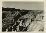
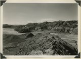
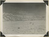
Flat lying Upper Jurassic (foreground) and Cretaceous strata bed abruptly upward against the Navajo on the flank of the East Kaibab monocline (left sky line). Table Cliffs (right sky line) is about 50 miles north. Paria Valley near Adairville. Kane County, UT. 1944
P0013 Herbert E. Gregory Photograph Collection
P0013n12_039_2886
102
Flat lying Upper Jurassic (foreground) and Cretaceous strata bed abruptly upward against the Navajo on the flank of the East Kaibab monocline (left sky line). Table Cliffs (right sky line) is about 50 miles north. Paria Valley near Adairville. Kane County, UT. 1944
P0013 Herbert E. Gregory Photograph Collection
P0013n12_039_2886
103
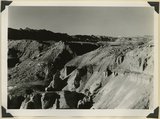
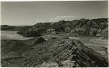
Eroded flank of the East Kaibab monocline at the junction of Paria River and Cottonwood Creek (left center). The sequence is Navajo (left), upper Jurassic (largely eroded), Dakota, Tropic, and Straight Cliffs. Kane County, UT, 1944
P0013 Herbert E. Gregory Photograph Collection
P0013n12_040_2887
104
Eroded flank of the East Kaibab monocline at the junction of Paria River and Cottonwood Creek (left center). The sequence is Navajo (left), upper Jurassic (largely eroded), Dakota, Tropic, and Straight Cliffs. Kane County, UT, 1944
P0013 Herbert E. Gregory Photograph Collection
P0013n12_040_2887
105
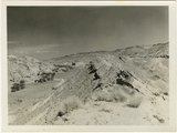
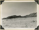
Looking south along Paria River from the mouth of Shurtz Gorge. Navajo sandstone in East Kaibab monocline is overlaid with decreasing dips by Upper Jurassic (banked against the Navajo), Dakota, and Tropic (foreground and left sky line). Erosion surface (middle distance) bevels upturned rocks. Kane County, UT, 1944
P0013 Herbert E. Gregory Photograph Collection
P0013n12_041_2888
106
Looking south along Paria River from the mouth of Shurtz Gorge. Navajo sandstone in East Kaibab monocline is overlaid with decreasing dips by Upper Jurassic (banked against the Navajo), Dakota, and Tropic (foreground and left sky line). Erosion surface (middle distance) bevels upturned rocks. Kane County, UT, 1944
P0013 Herbert E. Gregory Photograph Collection
P0013n12_041_2888
107
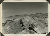
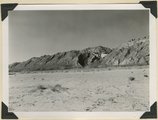
Panorama {a}. Flank of East Kaibab monocline, bordering alluvial floor of Paria Valley. Navajo sandstone (middle sky line), Upper Jurassic strata, and basal Cretaceous (left). Dips of 40 degrees decrease to 3 degrees within 1,000 feet. Kane County, UT, 1944
P0013 Herbert E. Gregory Photograph Collection
P0013n12_042_2889
108
Panorama {b}. Flank of East Kaibab monocline, bordering alluvial floor of Paria Valley. Navajo sandstone (middle sky line), Upper Jurassic strata, and basal Cretaceous (left). Dips of 40 degrees decrease to 3 degrees within 1,000 feet. Kane County, UT, 1944
P0013 Herbert E. Gregory Photograph Collection
P0013n12_042_2890
109
Panorama {c}. Flank of East Kaibab monocline, bordering alluvial floor of Paria Valley. Navajo sandstone (middle sky line), Upper Jurassic strata, and basal Cretaceous (left). Dips of 40 degrees decrease to 3 degrees within 1,000 feet. Kane County, UT, 1944
P0013 Herbert E. Gregory Photograph Collection
P0013n12_042_2891
110
Panorama {c}. Flank of East Kaibab monocline, bordering alluvial floor of Paria Valley. Navajo sandstone (middle sky line), Upper Jurassic strata, and basal Cretaceous (left). Dips of 40 degrees decrease to 3 degrees within 1,000 feet. Kane County, UT, 1944
P0013 Herbert E. Gregory Photograph Collection
P0013n12_042_2891
111
Panorama {d}. Flank of East Kaibab monocline, bordering alluvial floor of Paria Valley. Navajo sandstone (middle sky line), Upper Jurassic strata, and basal Cretaceous (left). Dips of 40 degrees decrease to 3 degrees within 1,000 feet. Kane County, UT, 1944
P0013 Herbert E. Gregory Photograph Collection
P0013n12_043_2892
112
Panorama {e}. Flank of East Kaibab monocline, bordering alluvial floor of Paria Valley. Navajo sandstone (middle sky line), Upper Jurassic strata, and basal Cretaceous (left). Dips of 40 degrees decrease to 3 degrees within 1,000 feet. Kane County, UT, 1944
P0013 Herbert E. Gregory Photograph Collection
P0013n12_043_2893
113
Pinnacles of Navajo sandstone in House Rock Valley along the course of Kaibab Creek. Eroded part of East Kaibab monocline. Kane County, UT, 1944
P0013 Herbert E. Gregory Photograph Collection
P0013n12_044_2894
114
Gap cut in Navajo sandstone by Kaibab Creek where it leaves its structural valley to cross East Kaibab monocline. Northward through the gap House Rock Valley and Kaibab Plateau are visible. Kane County, UT. 1944
P0013 Herbert E. Gregory Photograph Collection
P0013n12_044_2895
115
Joints and small faults in Navajo sandstone along the crest (Coxcomb) of East Kaibab monocline. Kane County, UT, 1944
P0013 Herbert E. Gregory Photograph Collection
P0013n12_045_2896
116
Paria River below White Rock Spring. Wall of Navajo sandstone capped by Carmel formation. Kane County, UT, 1944
P0013 Herbert E. Gregory Photograph Collection
P0013n12_046_2897
117
Paria river below White Rock Spring. Wall of Navajo sandstone capped by Carmel formation. Upper Jurassic rocks on right sky line. Kane County, UT, 1944
P0013 Herbert E. Gregory Photograph Collection
P0013n12_046_2898
118
Kaibab limestone (lower wall,left, breccia (marks unconformable contact), and basal Moenkopi limestone and shales. Mouth of Kaibab Gulch. Kane County, UT, 1944
P0013 Herbert E. Gregory Photograph Collection
P0013n12_047-048_2899
119
Kaibab limestone (lower wall,left, breccia (marks unconformable contact), and basal Moenkopi limestone and shales. Mouth of Kaibab Gulch. Kane County, UT, 1944
P0013 Herbert E. Gregory Photograph Collection
P0013n12_047_2899
120
Permian limestones (Kaibab) overlain by the Triassic Moenkopi. Head of Kaibab Gulch, along Kanab-Paria road. Kane County, UT, 1944
P0013 Herbert E. Gregory Photograph Collection
P0013n12_049_2900
121
Timpoweap member of the Moenkopi formation. Kaibab at base, upstream. East rim of the Kaibab Plateau near the UT-AZ line. Coconino County, AZ, 1944
P0013 Herbert E. Gregory Photograph Collection
P0013n12_049_2901
122
View looking east from Kaibab Plateau across House Rock Valley (invisible) to the Coxcomb Navajo sandstone in the East Kaibab monocline. Timpoweap member of the Moenkopi forms walls of local gulch. Kane County, UT, 1944
P0013 Herbert E. Gregory Photograph Collection
P0013n12_050_2902
123
Shinarump Conglomerate at Pioneer Gap. Kane County, UT, 1944
P0013 Herbert E. Gregory Photograph Collection
P0013n12_050_2903
124
Mesa capped by Dakota sandstone eroded from upper Jurassic Winsor (?) formation. Head of Ash Creek. Kane County, UT
P0013 Herbert E. Gregory Photograph Collection
P0013n12_051_2903A
125
Section of the Shinarump Cliffs (middle distance), east of Pioneer Gap. Shinarump conglomerate exposed by erosion of Moenkopi formation below and the basal strata of the Chinle formation above. Upper Chinle sandstones form Vermilion Cliffs (background).
P0013 Herbert E. Gregory Photograph Collection
P0013n12_052B
101
-
125
of
6,456
<
1
2
3
4
5
6
7
8
9
10
>