Home
Browse
Ask Us
Chat
Harmful Language Statement
Log in
Photo Archives
Advanced Search
About
Over 70,000 photos covering a variety of topics from Marriott Library Special Collections
Year
1845
1846
1847
1848
1849
1850
1851
1852
1853
1854
1855
1856
1857
1858
1859
1860
1861
1862
1863
1864
1865
1866
1867
1868
1869
1870
1871
1872
1873
1874
1875
1876
1877
1878
1879
1880
1881
1882
1883
1884
1885
1886
1887
1888
1889
1890
1891
1892
1893
1894
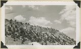
1895
1896
1897
1898
1899
1900
1901
1902
1903
1904
1905
1906
1907
1908
1909
1910
1911
1912
1913
1914
1915
1916
1917
1918
1919
1920
1921
1922
1923
1924
1925
1926
1927
1928
1929
1930
1931
1932
1933
1934
1935
1936
1937
1938
1939
1940
1941
1942
1943
1944
1945
1946
1947
1948
1949
1950
1951
1952
1953
1954
1955
1956
1957
1958
1959
1960
1961
1962
1963
1964
1965
1966
1967
1968
1969
1970
1971
1972
1973
1974
1975
1976
1977
1978
1979
1980
1981
1982
1983
1984
1985
1986
1987
1988
1989
1990
TO
1845
1846
1847
1848
1849
1850
1851
1852
1853
1854
1855
1856
1857
1858
1859
1860
1861
1862
1863
1864
1865
1866
1867
1868
1869
1870
1871
1872
1873
1874
1875
1876
1877
1878
1879
1880
1881
1882
1883
1884
1885
1886
1887
1888
1889
1890
1891
1892
1893
1894
1895
1896
1897
1898
1899
1900
1901
1902
1903
1904
1905
1906
1907
1908
1909
1910
1911
1912
1913
1914
1915
1916
1917
1918
1919
1920
1921
1922
1923
1924
1925
1926
1927
1928
1929
1930
1931
1932
1933
1934
1935
1936
1937
1938
1939
1940
1941
1942
1943
1944
1945
1946
1947
1948
1949
1950
1951
1952
1953
1954
1955
1956
1957
1958
1959
1960
1961
1962
1963
1964
1965
1966
1967
1968
1969
1970
1971
1972
1973
1974
1975
1976
1977
1978
1979
1980
1981
1982
1983
1984
1985
1986
1987
1988
1989
1990
Type
Image
3,443
Format
image/jpeg
2,782
application/pdf
661
Collection Name
Olive Woolley Burt
840
Charles Kelly
599
EIMCO Photograph Collection
250
Leo Leonard
210
Shipler Studio
178
Reo Robbins
153
Deseret Livestock Company
147
Everett Ruess Family
123
Wallace Stegner
111
Emigration Canyon History
109
Herbert E. Gregory
103
Albion W. and Agnes Sharp Caine
90
Mining Photograph Collection
83
Charles Neal
60
Rocky Mountain Power Company
52
G. Bennet Larson
51
Greek Archives
29
Fort Douglas
26
McIntyre Ranch
22
Vern Adix
22
Sumi Niiya Takemoto
20
Seiko and Sumi Oki Arakaki
19
Waldo Wilcox
18
Combined Metals Reduction Company
13
Geraldine Palmer Jones
13
Joe Hill Conference
10
Alta Club
8
Cotton Mission
8
Hope A. Hilton
8
Utah Postcard
8
Reva Beck Bosone
7
Wendover Utah Air Base
7
Japanese Church of Christ
6
Mike M. Masaoka
6
Millard F. Malin Photographs
5
Provo, Utah
5
Bill Wolverton
4
Henry Y. Kasai
4
Vyrie Gray
3
Stanley Murdock
2
Allen Publishing Company
1
Barbara J. Hamblin
1
Colorado
1
Italian
1
John Esplin
1
Orvil LaVell Sadler
1
Preston Nutter Corporation
1
U of U Fa.
1
U of U Presidents
1
Utah Recreation
1
Wasatch Mountain Club
1
More
Filters:
Date:
"1944"
Collection:
"uum_map"
Type:
"Image"
51
-
75
of
3,443
<
1
2
3
4
5
6
7
8
9
10
>
Gallery view
Number of results to display per page
10
25
50
100
200
Sort by Relevance
Sort by Title A-Z
Sort by Title Z-A
Sort by Date Ascending
Sort by Date Descending
Sort by Last Modified Ascending
Sort by Last Modified Descending
Sort by Photo Number
Title
Collection Number And Name
Photo Number
51
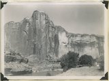
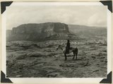
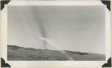
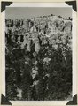
Escalante Canyon walls of Navajo sandstone at Big Bend camp. Moonlight view. Garfield County, UT, 1944
P0013 Herbert E. Gregory Photograph Collection
P0013n12_059_2915
52
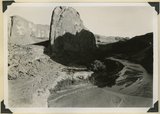
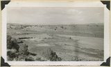
Escalante River at Big Bend, flowing west. After surrounding the tower of Navajo sandstone (center), the river comes within 300 feet of its east flowing section at the base of the wall (upper left). Garfield County, UT, 1944
P0013 Herbert E. Gregory Photograph Collection
P0013n12_060_2916
53
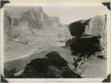
Escalante River at Big Bend, flowing east. At times of high water the stream flows across Kayenta formation at the meander neck (lower right). Garfield County, UT, 1944
P0013 Herbert E. Gregory Photograph Collection
P0013n12_061_2917
54
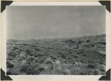
Surface of Navajo sandstone trenched by Escalante Canyon (right middle). Aquarius Plateau on skyline. Garfield County, UT, 1944
P0013 Herbert E. Gregory Photograph Collection
P0013n12_062_2918
55
Surface of Navajo sandstone between Escalante Canyon and Kaiparowits Plateau. Butte of Upper Jurassic rocks. Near head of Davis Creek. Garfield County, UT, 1944
P0013 Herbert E. Gregory Photograph Collection
P0013n12_062_2919
56
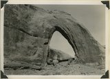
Gothic Arch. Width 174 feet, estimated height 190 feet. End of a buttress of Navajo sandstone resting on Kayenta. Soda Creek branch of Escalante River. Garfield County, UT, 1944
P0013 Herbert E. Gregory Photograph Collection
P0013n12_063_2920
57
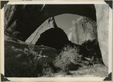
Natural bridge of Navajo sandstone. Span 85 feet, height to girder 76 feet. Willow Creek. Garfield County, UT, 1944
P0013 Herbert E. Gregory Photograph Collection
P0013n12_064_2921
58
Natural bridge of Navajo sandstone. Span 85 feet, height to girder 76 feet. Willow Creek. Garfield County, UT, 1944
P0013 Herbert E. Gregory Photograph Collection
P0013n12_064_2922
59
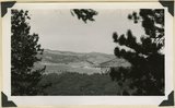
Looking west across Panguitch. Sevier River formation (foreground), alluvium (middle distance), basalt (left center), and pyroclastic slopes leading to Little Creek Peak (background), on the east wall of Bear Valley. Garfield County, UT, 1944
P0013 Herbert E. Gregory Photograph Collection
P0013n12_065_2923
60
Looking northwest across Horse Lake Valley. Basalt (foreground), Pyroclastics (background). Garfield County, UT, 1944
P0013 Herbert E. Gregory Photograph Collection
P0013n12_066_2924
61
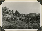
Treeless slope developed on pyroclastic and igneous rocks typical of areas west of Panguitch Creek. Garfield County, UT, 1944
P0013 Herbert E. Gregory Photograph Collection
P0013n12_066_2925
62
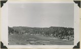
South Fork of Sevier River below mouth of Asay Creek. Garfield County, UT, 1944
P0013 Herbert E. Gregory Photograph Collection
P0013n12_067_2926
63
Lower Castle Creek Valley; broad floor of low gradient developed in Brian Head formation. Garfield County, UT, 1944
P0013 Herbert E. Gregory Photograph Collection
P0013n12_067_2927
64
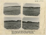
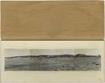
(Panorama A, B, C, D) Blue Springs Meadows. A stream leading south (left) to Mammoth Creek blocked by basalts from Miller Knoll (right sky line) became a lake that eventuallly cut an outlet through the Brian Head formation (upper left).
P0013 Herbert E. Gregory Photograph Collection
P0013n12_068-069_2929ABCD
65
Panorama--4 photographs. Blue Springs meadows. A former valley leading to Mammoth Creek blocked by basalts from Miller Knoll (right skyline) became a lake that eventually cut an outlet northward through the Brian Head formation (upper left). Garfield County, UT, 1944
P0013 Herbert E. Gregory Photograph Collection
P0013n12_068-069_pan
66
Blue Springs meadow at Leigh ranch. Stream from big springs (lower left) meanders across an ancient lake bed and escapes through a water gap (center distance). Garfield County, UT, 1944
P0013 Herbert E. Gregory Photograph Collection
P0013n12_068_2928
67
Panorama (a): Blue Springs meadows. A former valley leading to Mammoth Creek blocked by basalts from Miller Knoll (right skyline) became a lake that eventually cut an outlet northward through the Brian Head formation (upper left). Garfield County, UT, 1944
P0013 Herbert E. Gregory Photograph Collection
P0013n12_068_2929A
68
Panorama (b): Blue Springs meadows. A former valley leading to Mammoth Creek blocked by basalts from Miller Knoll (right skyline) became a lake that eventually cut an outlet northward through the Brian Head formation (upper left). Garfield County, UT, 1944
P0013 Herbert E. Gregory Photograph Collection
P0013n12_069_2929B
69
Panorama (c): Blue Springs meadows. A former valley leading to Mammoth Creek blocked by basalts from Miller Knoll (right skyline) became a lake that eventually cut an outlet northward through the Brian Head formation (upper left). Garfield County, UT, 1944
P0013 Herbert E. Gregory Photograph Collection
P0013n12_069_2929C
70
Panorama (d): Blue Springs meadows. A former valley leading to Mammoth Creek blocked by basalts from Miller Knoll (right skyline) became a lake that eventually cut an outlet northward through the Brian Head formation (upper left). Garfield County, UT, 1944
P0013 Herbert E. Gregory Photograph Collection
P0013n12_069_2929D
71
Sheep Flat. Broad treeless highland crossed by shallow stream runways between Coalpits Wash and Pinion Ridge. A little modified part of the eastward dipping (right) surface of Markagunt Plateau. Garfield County, UT, 1944
P0013 Herbert E. Gregory Photograph Collection
P0013n12_070_2930
72
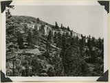
Wasatch limestones, overlying Cretaceous; southern limit of Pink Cliffs. Dairy Canyon. Kane County, UT, 1944
P0013 Herbert E. Gregory Photograph Collection
P0013n12_070_2931
73
Brian Head formation, consolidated (white wall) and disintegrated (upper slopes), and pink Wasatch limestones (lowest slopes). Seamans Canyon west of Gravel Pass. Kane County, UT, 1944
P0013 Herbert E. Gregory Photograph Collection
P0013n12_071_2932
74
Brian Head formation, consolidated (white wall) and disintegrated (upper slopes), and pink Wasatch limestones (lowest slopes). Seamans Canyon west of Gravel Pass. Kane County, UT, 1944
P0013 Herbert E. Gregory Photograph Collection
P0013n12_071_2933
75
Brian Head formation underlain by pink Wasatch limestone on Highway 89, 2± miles north of Castle Creek. Garfield County, UT, 1944
P0013 Herbert E. Gregory Photograph Collection
P0013n12_072_2934
51
-
75
of
3,443
<
1
2
3
4
5
6
7
8
9
10
>