Home
Browse
Ask Us
Chat
Harmful Language Statement
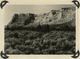
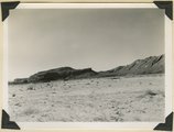
Log in
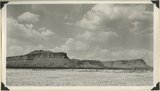
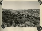
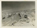
Photo Archives
Advanced Search
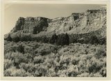
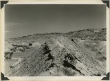
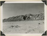
About
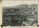
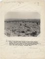
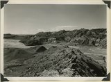
Over 70,000 photos covering a variety of topics from Marriott Library Special Collections
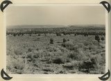
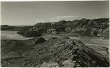
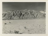
Year
1845
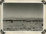
1846
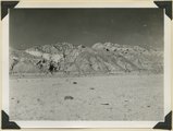
1847
1848
1849
1850
1851
1852
1853
1854
1855
1856
1857
1858
1859
1860
1861
1862
1863
1864
1865
1866
1867
1868
1869
1870
1871
1872
1873
1874
1875
1876
1877
1878
1879
1880
1881
1882
1883
1884
1885
1886
1887
1888
1889
1890
1891
1892
1893
1894
1895
1896
1897
1898
1899
1900
1901
1902
1903
1904
1905
1906
1907
1908
1909
1910
1911
1912
1913
1914
1915
1916
1917
1918
1919
1920
1921
1922
1923
1924
1925
1926
1927
1928
1929
1930
1931
1932
1933
1934
1935
1936
1937
1938
1939
1940
1941
1942
1943
1944
1945
1946
1947
1948
1949
1950
1951
1952
1953
1954
1955
1956
1957
1958
1959
1960
1961
1962
1963
1964
1965
1966
1967
1968
1969
1970
1971
1972
1973
1974
1975
1976
1977
1978
1979
1980
1981
1982
1983
1984
1985
1986
1987
1988
1989
1990
TO
1845
1846
1847
1848
1849
1850
1851
1852
1853
1854
1855
1856
1857
1858
1859
1860
1861
1862
1863
1864
1865
1866
1867
1868
1869
1870
1871
1872
1873
1874
1875
1876
1877
1878
1879
1880
1881
1882
1883
1884
1885
1886
1887
1888
1889
1890
1891
1892
1893
1894
1895
1896
1897
1898
1899
1900
1901
1902
1903
1904
1905
1906
1907
1908
1909
1910
1911
1912
1913
1914
1915
1916
1917
1918
1919
1920
1921
1922
1923
1924
1925
1926
1927
1928
1929
1930
1931
1932
1933
1934
1935
1936
1937
1938
1939
1940
1941
1942
1943
1944
1945
1946
1947
1948
1949
1950
1951
1952
1953
1954
1955
1956
1957
1958
1959
1960
1961
1962
1963
1964
1965
1966
1967
1968
1969
1970
1971
1972
1973
1974
1975
1976
1977
1978
1979
1980
1981
1982
1983
1984
1985
1986
1987
1988
1989
1990
Type
Image
3,443
Format
image/jpeg
2,782
application/pdf
661
Collection Name
Olive Woolley Burt
840
Charles Kelly
599
EIMCO Photograph Collection
250
Leo Leonard
210
Shipler Studio
178
Reo Robbins
153
Deseret Livestock Company
147
Everett Ruess Family
123
Wallace Stegner
111
Emigration Canyon History
109
Herbert E. Gregory
103
Albion W. and Agnes Sharp Caine
90
Mining Photograph Collection
83
Charles Neal
60
Rocky Mountain Power Company
52
G. Bennet Larson
51
Greek Archives
29
Fort Douglas
26
McIntyre Ranch
22
Vern Adix
22
Sumi Niiya Takemoto
20
Seiko and Sumi Oki Arakaki
19
Waldo Wilcox
18
Combined Metals Reduction Company
13
Geraldine Palmer Jones
13
Joe Hill Conference
10
Alta Club
8
Cotton Mission
8
Hope A. Hilton
8
Utah Postcard
8
Reva Beck Bosone
7
Wendover Utah Air Base
7
Japanese Church of Christ
6
Mike M. Masaoka
6
Millard F. Malin Photographs
5
Provo, Utah
5
Bill Wolverton
4
Henry Y. Kasai
4
Vyrie Gray
3
Stanley Murdock
2
Allen Publishing Company
1
Barbara J. Hamblin
1
Colorado
1
Italian
1
John Esplin
1
Orvil LaVell Sadler
1
Preston Nutter Corporation
1
U of U Fa.
1
U of U Presidents
1
Utah Recreation
1
Wasatch Mountain Club
1
More
Filters:
Date:
"1944"
Collection:
"uum_map"
Type:
"Image"
1
-
25
of
3,443
<
1
2
3
4
5
6
7
8
9
10
>
Gallery view
Number of results to display per page
10
25
50
100
200
Sort by Relevance
Sort by Title A-Z
Sort by Title Z-A
Sort by Date Ascending
Sort by Date Descending
Sort by Last Modified Ascending
Sort by Last Modified Descending
Sort by Photo Number
Title
Collection Number And Name
Photo Number
1
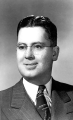
Gordon Miller, University of Utah faculty
P0305 University of Utah Archives Photograph Collection - A-Fa.
A-Fa.MillerGordon.
2
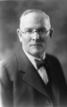
George Thomas, University of Utah president
P0305 University of Utah Archives Photograph Collection - A-Fa. Presidents
A-Fa.Thomas.
3
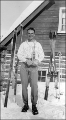
Junior Bounous holding an award.
P0004 Wasatch Mountain Club Photograph Collection
P0004n0017
4
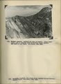
Herbert E. Gregory Book 12: Colorado Plateau, Province, 1942-1944
P0013 Herbert E. Gregory Photograph Collection
P0013n12
5
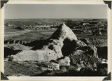
Vermillion Cliffs. Chinle formation. Petrified Forest member (foreground and basalt slopes) and upper sandstone. Flag Point, Kane County, UT. 1944
P0013 Herbert E. Gregory Photograph Collection
P0013n12_031_2879
6
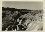
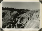
West wall of Seaman Wash
P0013 Herbert E. Gregory Photograph Collection
P0013n12_032_2880
7
West wall of Seaman Wash
P0013 Herbert E. Gregory Photograph Collection
P0013n12_032_2880
8
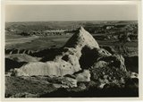
Vermillion Cliffs. Chinle formation. Petrified Forest member eroded into bedlands; upper sandstone capped by outliers of Wingate. Lower Road Creek. Kane County, UT, 1944
P0013 Herbert E. Gregory Photograph Collection
P0013n12_033_2881
9
Looking southward across House Rock Valley from West Clark Bench. West dipping Navajo sandstone trenched by Kaibab Creek (middle distance) is a part of the East Kaibab monocline; east dipping limestones (skyline) are the cap rocks of the Kaibab upwarp. Kane County, UT, 1944
P0013 Herbert E. Gregory Photograph Collection
P0013n12_035_2882
10
Looking south, up dip, across West Clark Bench, Upper Jurassic and Dakota (butte), to the Paria Terrace, Navajo sandstone. Paria River, which passes through 'The Gap' is joined by Kaibab Creek. Kane County, UT. 1944
P0013 Herbert E. Gregory Photograph Collection
P0013n12_036_2883
11
Looking south, up dip, across West Clark Bench, Upper Jurassic and Dakota (butte), to the Paria Terrace, Navajo sandstone. Paria River, which passes through 'The Gap' is joined by Kaibab Creek. Kane County, UT. 1944
P0013 Herbert E. Gregory Photograph Collection
P0013n12_036_2883
12
Looking east across Paria River Canyon where it separates West and East Clark Benches. Upper Jurassic (foreground) and Navajo (background) dip northeast. Navajo Mountain and Kaiparowits Plateau are on opposite sides of Glen Canyon. Kane County, UT. 1944
P0013 Herbert E. Gregory Photograph Collection
P0013n12_037_2884
13
Looking south (up dip) down the Paria River, which has widened its floor and dissected its borders in Upper Jurassic rocks (foreground) and cut a deep narrow canyon in the Navajo sandstone (background). Site of the abandoned Adairville. Kane County UT, 1944
P0013 Herbert E. Gregory Photograph Collection
P0013n12_038_2885
14
Looking south (up dip) down the Paria River, which has widened its floor and dissected its borders in Upper Jurassic rocks (foreground) and cut a deep narrow canyon in the Navajo sandstone (background). Site of the abandoned Adairville. Kane County UT, 1944
P0013 Herbert E. Gregory Photograph Collection
P0013n12_038_2885
15
Flat lying Upper Jurassic (foreground) and Cretaceous strata bed abruptly upward against the Navajo on the flank of the East Kaibab monocline (left sky line). Table Cliffs (right sky line) is about 50 miles north. Paria Valley near Adairville. Kane County, UT. 1944
P0013 Herbert E. Gregory Photograph Collection
P0013n12_039_2886
16
Flat lying Upper Jurassic (foreground) and Cretaceous strata bed abruptly upward against the Navajo on the flank of the East Kaibab monocline (left sky line). Table Cliffs (right sky line) is about 50 miles north. Paria Valley near Adairville. Kane County, UT. 1944
P0013 Herbert E. Gregory Photograph Collection
P0013n12_039_2886
17
Eroded flank of the East Kaibab monocline at the junction of Paria River and Cottonwood Creek (left center). The sequence is Navajo (left), upper Jurassic (largely eroded), Dakota, Tropic, and Straight Cliffs. Kane County, UT, 1944
P0013 Herbert E. Gregory Photograph Collection
P0013n12_040_2887
18
Eroded flank of the East Kaibab monocline at the junction of Paria River and Cottonwood Creek (left center). The sequence is Navajo (left), upper Jurassic (largely eroded), Dakota, Tropic, and Straight Cliffs. Kane County, UT, 1944
P0013 Herbert E. Gregory Photograph Collection
P0013n12_040_2887
19
Looking south along Paria River from the mouth of Shurtz Gorge. Navajo sandstone in East Kaibab monocline is overlaid with decreasing dips by Upper Jurassic (banked against the Navajo), Dakota, and Tropic (foreground and left sky line). Erosion surface (middle distance) bevels upturned rocks. Kane County, UT, 1944
P0013 Herbert E. Gregory Photograph Collection
P0013n12_041_2888
20
Looking south along Paria River from the mouth of Shurtz Gorge. Navajo sandstone in East Kaibab monocline is overlaid with decreasing dips by Upper Jurassic (banked against the Navajo), Dakota, and Tropic (foreground and left sky line). Erosion surface (middle distance) bevels upturned rocks. Kane County, UT, 1944
P0013 Herbert E. Gregory Photograph Collection
P0013n12_041_2888
21
Panorama {a}. Flank of East Kaibab monocline, bordering alluvial floor of Paria Valley. Navajo sandstone (middle sky line), Upper Jurassic strata, and basal Cretaceous (left). Dips of 40 degrees decrease to 3 degrees within 1,000 feet. Kane County, UT, 1944
P0013 Herbert E. Gregory Photograph Collection
P0013n12_042_2889
22
Panorama {b}. Flank of East Kaibab monocline, bordering alluvial floor of Paria Valley. Navajo sandstone (middle sky line), Upper Jurassic strata, and basal Cretaceous (left). Dips of 40 degrees decrease to 3 degrees within 1,000 feet. Kane County, UT, 1944
P0013 Herbert E. Gregory Photograph Collection
P0013n12_042_2890
23
Panorama {c}. Flank of East Kaibab monocline, bordering alluvial floor of Paria Valley. Navajo sandstone (middle sky line), Upper Jurassic strata, and basal Cretaceous (left). Dips of 40 degrees decrease to 3 degrees within 1,000 feet. Kane County, UT, 1944
P0013 Herbert E. Gregory Photograph Collection
P0013n12_042_2891
24
Panorama {c}. Flank of East Kaibab monocline, bordering alluvial floor of Paria Valley. Navajo sandstone (middle sky line), Upper Jurassic strata, and basal Cretaceous (left). Dips of 40 degrees decrease to 3 degrees within 1,000 feet. Kane County, UT, 1944
P0013 Herbert E. Gregory Photograph Collection
P0013n12_042_2891
25
Panorama {d}. Flank of East Kaibab monocline, bordering alluvial floor of Paria Valley. Navajo sandstone (middle sky line), Upper Jurassic strata, and basal Cretaceous (left). Dips of 40 degrees decrease to 3 degrees within 1,000 feet. Kane County, UT, 1944
P0013 Herbert E. Gregory Photograph Collection
P0013n12_043_2892
1
-
25
of
3,443
<
1
2
3
4
5
6
7
8
9
10
>