Home
Browse
Ask Us
Chat
Harmful Language Statement
Log in
Photo Archives
Advanced Search
About
Over 70,000 photos covering a variety of topics from Marriott Library Special Collections
Year
1845
1846
1847
1848
1849
1850
1851
1852
1853
1854
1855
1856
1857
1858
1859
1860
1861
1862
1863
1864
1865
1866
1867
1868
1869
1870
1871
1872
1873
1874
1875
1876
1877
1878
1879
1880
1881
1882
1883
1884
1885
1886
1887
1888
1889
1890
1891
1892
1893
1894
1895
1896
1897
1898
1899
1900
1901
1902
1903
1904
1905
1906
1907
1908
1909
1910
1911
1912
1913
1914
1915
1916
1917
1918
1919
1920
1921
1922
1923
1924
1925
1926
1927
1928
1929
1930
1931
1932
1933
1934
1935
1936
1937
1938
1939
1940
1941
1942
1943
1944
1945
1946
1947
1948
1949
1950
1951
1952
1953
1954
1955
1956
1957
1958
1959
1960
1961
1962
1963
1964
1965
1966
1967
1968
1969
1970
1971
1972
1973
1974
1975
1976
1977
1978
1979
1980
1981
1982
1983
1984
1985
1986
1987
1988
1989
1990
1991
1992
1993
1994
1995
1996
1997
1998
1999
2000
2001
2002
2003
2004
2005
TO
1845
1846
1847
1848
1849
1850
1851
1852
1853
1854
1855
1856
1857
1858
1859
1860
1861
1862
1863
1864
1865
1866
1867
1868
1869
1870
1871
1872
1873
1874
1875
1876
1877
1878
1879
1880
1881
1882
1883
1884
1885
1886
1887
1888
1889
1890
1891
1892
1893
1894
1895
1896
1897
1898
1899
1900
1901
1902
1903
1904
1905
1906
1907
1908
1909
1910
1911
1912
1913
1914
1915
1916
1917
1918
1919
1920
1921
1922
1923
1924
1925
1926
1927
1928
1929
1930
1931
1932
1933
1934
1935
1936
1937
1938
1939
1940
1941
1942
1943
1944
1945
1946
1947
1948
1949
1950
1951
1952
1953
1954
1955
1956
1957
1958
1959
1960
1961
1962
1963
1964
1965
1966
1967
1968
1969
1970
1971
1972
1973
1974
1975
1976
1977
1978
1979
1980
1981
1982
1983
1984
1985
1986
1987
1988
1989
1990
1991
1992
1993
1994
1995
1996
1997
1998
1999
2000
2001
2002
2003
2004
2005
Type
Image
2,995
Image/StillImage
1,330
Format
image/jpeg
5,370
Collection Name
Charles Kelly
599
Everett Ruess Family
482
Olive Woolley Burt
348
Japanese American relocation photograph collection, 1942-1943
321
EIMCO Photograph Collection
250
The Institute of the American West photograph collection, 1886-1985
214
Reo Robbins
202
Shipler Studio
196
Wallace and Mary Doi
155
Deseret Livestock Company
147
Ray Yourdon
144
Topaz, Utah and Hispanics in Utah films, 1940-1990
143
Sumi Niiya Takemoto
113
Emigration Canyon History
108
J. Willard and Alice Sheets Marriott
107
Vern Adix
102
Wallace Stegner
101
Albion W. and Agnes Sharp Caine
98
Mining Photograph Collection
83
Ruth Harwood
73
Herbert E. Gregory
66
Maud May Babcock
66
Charles Neal
60
Leo Leonard
60
Marriner S. Eccles
58
Kennecott Copper Corporation
57
G. Bennet Larson
56
Ivy Baker Priest
47
Philo T. Farnsworth
45
Utah Schools photograph collection
45
Salt Lake City, Utah
39
Faith Terasawa
33
Bingham Canyon
29
Greek Archives
29
C. Lowell Lees
25
Fort Douglas
25
Gosiute Indians
24
Utah Railroads
24
E. A. Taylor
23
American Red Cross
21
George and Jane Beppu Sakashita
21
McIntyre Ranch
21
Waldo Wilcox
18
JoAnne C. Swindle photograph collection
16
Combined Metals Reduction Company
13
Croydon Utah/Devil's Slide Cement Plant
13
George Snell
13
Utah's Silver Queen: Susanna Egera Bransford Emery Holmes Delitch Engalitcheff photograph collection
13
Vontella Hess Bucholz Kimball
12
Alberta Henry
11
Ivor Sharp
11
Julia Farnsworth Lund Wassmer
11
Jean Westwood
10
Joe Hill Conference
10
LeRoy Robertson photograph collection, 1945-1960
10
Portrait photograph collection
10
Wasatch Mountain Club
10
Geraldine Palmer Jones
9
Seiko and Sumi Oki Arakaki
9
Sigmund and Emma Helwing
9
Alta Club
8
Cotton Mission
8
Ralph Chamberlin
8
Utah Postcard
8
Byron A. Hunter photograph collection
7
Hope A. Hilton
7
John Hamilton Morgan
7
Lucius Marsden Durham
7
Mike M. Masaoka
7
Reva Beck Bosone
7
Salt Lake Oratorio Society photograph collection
7
Sylvia Eugene Nilsen
7
Utah Humanities Research Foundation
7
Wendover Utah Air Base
7
Dave M. Tatsuno
6
Francis Armstrong
6
Joseph E. Johnson
6
Uheiji Charles Akita
6
United States Fuel Corporation
6
Japanese Church of Christ
5
John A. Peperakis
5
Louis S. Goodman
5
Masaru Horiuchi
5
Millard F. Malin Photographs
5
Provo, Utah
5
Rocky Mountain Power Company
5
Bill Wolverton
4
Francis Urry
4
Henry Y. Kasai
4
Rose Thomas Graham
4
Wanda Clayton Thomas
4
B. Floyd Farr
3
Clarice Short photograph collection
3
Jack Warren Keuffel photograph collection, 1946-1974
3
John W. Summerhays
3
Joy and Lee She Ju digital photograph collection
3
Maurice Abravanel
3
Park City, Utah
3
Sho and Toshi Yamada Higashi digital photograph collection
3
Vyrie Gray
3
Alice Lovina Manning Photographs
2
Alvin G. and Lena M. Pack
2
Arch Leonard Madsen
2
Asael Carlyle
2
Blacks in Utah
2
Burton W. Musser photograph collection, 1900-1966
2
Charles H. Monson photograph collection
2
Daniel Hadlond Thomas
2
David Breck Morris
2
David Oman McKay
2
E. Jay Bell
2
Earl Wells
2
Edna Clark Ericksen
2
Esther Landa photograph collection
2
George A. Smith
2
Gilsonite Mining
2
Harry L. A. Culmer photograph collection
2
Masaji Roy Yoshinaga Photographs
2
Sara Barnard Johnston photograph collection
2
Stanley Murdock
2
Tooele Army Depot
2
Barbara J. Hamblin
1
Benjamin M. Roe
1
Blanche Kendall McKey
1
Cheves Walling
1
Colorado
1
Darrell J. Greenwell
1
Dawn Aoki photograph collection
1
Elma Oman Klitgaard
1
Elmore LeRoy photograph collection
1
George Reynolds
1
Helen Bowring Ure photograph collection
1
Howard D. Johnson
1
Italian
1
Japanese American Citizens League Japanese in Utah Exhibit
1
John Esplin
1
Joseph Kingsbury
1
Knight Belnap Kerr photograph collection, 1935-1942
1
Omer Call Stewart photograph collection
1
Orvil LaVell Sadler
1
Preston D. Linford Photograph Collection
1
Preston Nutter Corporation
1
Sunstone Foundation photograph collection
1
Topaz Oral Histories photograph collection
1
U of U Fa.
1
U of U Presidents
1
Utah Recreation
1
Utah State AFL-CIO
1
More
Filters:
Date:
"1942"
Format:
"image/jpeg"
Collection:
"uum_map"
76
-
100
of
5,370
<
1
2
3
4
5
6
7
8
9
10
>
Gallery view
Number of results to display per page
10
25
50
100
200
Sort by Relevance
Sort by Title A-Z
Sort by Title Z-A
Sort by Date Ascending
Sort by Date Descending
Sort by Last Modified Ascending
Sort by Last Modified Descending
Sort by Photo Number
Title
Collection Number And Name
Photo Number
76
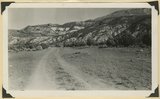
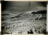
Surface of Kolob Terrace developed on Cretaceous strata. Three Knolls (basalt) on skyline. Iron County, UT, 1942
P0013 Herbert E. Gregory Photograph Collection
P0013n11_187_2826
77
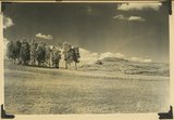
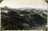
View looking northeast across Kolob Terrace. Basalt (foreground), Cretaceous trenched by Crystal Creek (middle), Pink Cliffs-Wasatch (skyline), lower east slope of Black Mountain (extreme left), 'The Gap,' twin peaks (right skyline), stands just south of Navajo Lake. Iron County, UT, 1942
P0013 Herbert E. Gregory Photograph Collection
P0013n11_188_2827
78
Arrangement of formations at Squaw Canyon along the line of the Kanarra fold. Triassic; Navajo upper Jurassic (Carmel, Entrada, Curtis, Winsor); Cretaceous. Steep dips of lower formations progressively flatten eastward (right). Iron County, UT, 1942
P0013 Herbert E. Gregory Photograph Collection
P0013n11_188_2828
79
Black Mountain culminating in Richardson Peak (altitude 9900 feet), viewed from southwest. Eroded crater and extensive basaltic flows overlying Cretaceous and Tertiary sediments. View looking north east edge of Kolob Terrace. Iron County, UT, 1942
P0013 Herbert E. Gregory Photograph Collection
P0013n11_189_2830
80
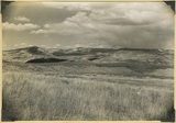
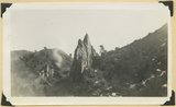
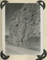
Shurtz Creek alcove. Pyramids of upturned Navajo sandstone (center; Triassic below; upper Jurassic Cretaceous and basalt above. Strata involved in the Kanarra fold. Iron County, UT
P0013 Herbert E. Gregory Photograph Collection
P0013n11_189_2830ABCD
81
"Pryor Knoll, eroded basaltic cone and lava flows over Cretaceous rocks. View looking northwest. Western edge of Kolob Terrace. Just back of the yellow pines are the cliffs at the head of the westward flowing Shurtz Creek. Iron County, UT, 1942
P0013 Herbert E. Gregory Photograph Collection
P0013n11_190_2831
82
View looking northeast across Kolob Terrace developed on Cretaceous strata. Pink Cliffs Tertiary (skyline), Black Mountain Volcano (upper left). Iron County, UT, 1942
P0013 Herbert E. Gregory Photograph Collection
P0013n11_190_2832
83
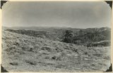
Piute Highlands. View looking northeast across Parowan and Benson Canyons from base of Applegate Ridge. Rim of Markagunt Plateau (middle skyline); Knob and ridges of Wasatch (middle distance); rhyolite foreground. Iron County, UT. 1942
P0013 Herbert E. Gregory Photograph Collection
P0013n11_191_2833
84
Piute Highlands. View looking northeast across Parowan and Benson Canyons from base of Applegate Ridge. Rim of Markagunt Plateau (middle skyline); Knob and ridges of Wasatch (middle distance); rhyolite foreground. Iron County, UT. 1942
P0013 Herbert E. Gregory Photograph Collection
P0013n11_191_2834
85
Piute Highlands. View looking south from Applegate Ridge across upper Summit Creek. Wasatch in Sugar Loaf Peak (upper left); rhyolite on Summit ridge, middle skyline; Cretaceous (foreground). Iron County, UT, 1942
P0013 Herbert E. Gregory Photograph Collection
P0013n11_192_2835
86
Piute Highlands. View looking north from near the base of Eagle Peak across branches of Summit Creek. Parowan Creek to snow capped Tushar Mountains (skyline); rhyolite and Cretaceous in the foreground; Cretaceous, Tertiary, and lavas beyond. Iron County, UT, 1942
P0013 Herbert E. Gregory Photograph Collection
P0013n11_192_2836
87
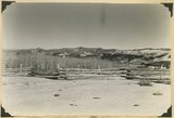
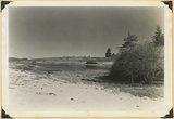
Piute Highlands. Glacial lake and moraine, Moseman (Dry Lakes) Valley. Iron County, UT, 1942
P0013 Herbert E. Gregory Photograph Collection
P0013n11_193_2837
88
Lake like no 2837, about a half mile down valley
P0013 Herbert E. Gregory Photograph Collection
P0013n11_193_2838
89
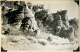
Conglomerate within the Wasatch formation (top and bottom). Bowery Canyon. Iron County, UT, 1942
P0013 Herbert E. Gregory Photograph Collection
P0013n11_194_2839
90
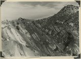
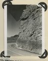
Fault contact of Carmel (right) and Curtis (left). Coal Canyon above the mouth of Rocky Hollow. Iron County, UT, 1942
P0013 Herbert E. Gregory Photograph Collection
P0013n11_194_2840
91
Hurricane Cliffs, formed by westward dipping Moenkopi strata involved in the Kanarra fold. Hurricane fault passes along the base and through the valley of Murie Creek (left); thick alluvium on the downthrown block (foreground). Iron County, UT, 1942
P0013 Herbert E. Gregory Photograph Collection
P0013n11_195_2841
92
Same as 2841, between Murie and Kanarra Creeks. Jurassic and younger strata (background)
P0013 Herbert E. Gregory Photograph Collection
P0013n11_196_2842
93
View south from the base of Horseranch Mountain, across the three deep canyon branches of Taylor Creek. Timber Top Mesa (middle skyline); Navajo sandstone (in walls); Carmel (general surface); Entrada (left center); Smith Mesa, Triassic rocks (upper right); towers of Zion National Park (upper left). Iron County, UT, 1942
P0013 Herbert E. Gregory Photograph Collection
P0013n11_196_2843
94
Fault near the mouth of Maple Canyon looking north, upthrown block at left. Iron County, UT, 1942
P0013 Herbert E. Gregory Photograph Collection
P0013n11_197_2844
95
Moenkopi beds upturned in the Kanarra fold and broken by a fault. Lawrence Canyon, Iron County, UT, 1942
P0013 Herbert E. Gregory Photograph Collection
P0013n11_197_2845
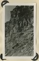
96
Moenkopi formation, Shnabkaib and upper red members. Chinle (upper right), knob of Shinarump offset by faulting (center skyline). Near mouth of Coal Canyon. Iron County, UT, 1942
P0013 Herbert E. Gregory Photograph Collection
P0013n12_001_2846
97
Parunuweap formation, thin bedded phase; overlies upturned Moenkopi, Lawrence Canyon, Iron County, UT, 1942. View near mouth of Lawrence Canyon.
P0013 Herbert E. Gregory Photograph Collection
P0013n12_002_2847
98
Parunuweap formation, covered by basalt flow. La Verkin Canyon, Washington County, UT, 1942
P0013 Herbert E. Gregory Photograph Collection
P0013n12_002_2848
99
Parunuweap formation, covered by basalt flow. La Verkin Canyon, Washington County, UT, 1942
P0013 Herbert E. Gregory Photograph Collection
P0013n12_003_2849
100
Parunuweap formation, overlying eroded Moenkopi strata. Federal highway 15, Virgin River Valley, near Grafton. Washington County, UT, 1942
P0013 Herbert E. Gregory Photograph Collection
P0013n12_003_2850
76
-
100
of
5,370
<
1
2
3
4
5
6
7
8
9
10
>