|
|
Title | Collection Number And Name | Photo Number |
| 126 |
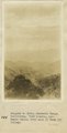 |
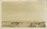
Panamint Range, California. View looking into Death Valley from head of Wood(?) Valley | P0013 Herbert E. Gregory Photograph Collection | P0013n08_192_1719 |
| 127 |
 |
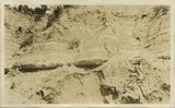
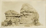
Searles Lake, California. Columns of tufa south end of Searles Lake | P0013 Herbert E. Gregory Photograph Collection | P0013n08_193_1720 |
| 128 |
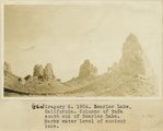 |
Searles Lake, California. Columns of tufa south end of Searles Lake. Marks water level of ancient lake | P0013 Herbert E. Gregory Photograph Collection | P0013n08_193_1721 |
| 129 |
 |
Herbert E. Gregory Book 9: Utah, California, 1924-1928 | P0013 Herbert E. Gregory Photograph Collection | P0013n09 |
| 130 |
 |
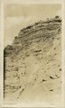
Limestone in 'Marine Jurassic' at a dry waterfall tributary to Virgin River, 2 miles SW of Mt. Carmel | P0013 Herbert E. Gregory Photograph Collection | P0013n09_001_1722 |
| 131 |
 |
Banded, friable sands, 'Marine Jurassic' between limestone bed and gypsum, 2 miles SW of Mt. Carmel | P0013 Herbert E. Gregory Photograph Collection | P0013n09_001_1723 |
| 132 |
 |
Banded, friable sands, 'Marine Jurassic' between limestone bed and gypsum, 2 miles SW of Mt. Carmel | P0013 Herbert E. Gregory Photograph Collection | P0013n09_002_1724 |
| 133 |
 |
Banded red and white sands. 'Marine Jurassic', immediately west of Cannonville | P0013 Herbert E. Gregory Photograph Collection | P0013n09_002_1725 |
| 134 |
 |
Banded red and white sands. 'Marine Jurassic', immediately west of Cannonville | P0013 Herbert E. Gregory Photograph Collection | P0013n09_003_1726 |
| 135 |
 |
Banded red and white sands. 'Marine Jurassic', immediately west of Cannonville | P0013 Herbert E. Gregory Photograph Collection | P0013n09_004_1727 |
| 136 |
 |
Banded red and white sands. 'Marine Jurassic', immediately west of Cannonville | P0013 Herbert E. Gregory Photograph Collection | P0013n09_005_1728 |
| 137 |
 |
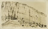
Sandstone and shale, 'Marine Jurassic'. Wall of Paria River, 3 miles below Cannonville | P0013 Herbert E. Gregory Photograph Collection | P0013n09_005_1729 |
| 138 |
 |
Ripple-marked sandstone, Marine Jurassic, from bed 40 feet above top of Navajo sandstone, Rock Spring Gulch, 6 miles below Cannonville. S.S. Johnson, packer, in foreground | P0013 Herbert E. Gregory Photograph Collection | P0013n09_005_1730 |
| 139 |
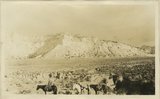 |
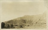
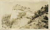
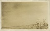
General view, wall of Dry Valley, 'Marine Jurassic', with Dakota top. Kane County, UT. 1924 | P0013 Herbert E. Gregory Photograph Collection | P0013n09_006_1731 |
| 140 |
 |
Banded shales with 3 beds of gypsum, 'Marine Jurassic,' Cottonwood Wash section. Kane County, UT, 1924 | P0013 Herbert E. Gregory Photograph Collection | P0013n09_006_1732 |
| 141 |
 |
Contact McElmo and Dakota, Henrieville Wash. Garfield County, UT, 1924 | P0013 Herbert E. Gregory Photograph Collection | P0013n09_007_1733 |
| 142 |
 |
Cannonville, UT, looking east. September, 1924 | P0013 Herbert E. Gregory Photograph Collection | P0013n09_007_1734 |
| 143 |
 |
Vegetation (pinion, cedar) in shales just above Navajo sandstone, Cottonwood Wash, Kane County, UT, 1924 | P0013 Herbert E. Gregory Photograph Collection | P0013n09_008_1735 |
| 144 |
 |
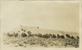
General view upper two thirds Waweap beds 1 mile southwest of Cannonville, Garfield County, UT 1924 | P0013 Herbert E. Gregory Photograph Collection | P0013n09_008_1736 |
| 145 |
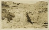 |
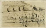
Detail view showing change in massiveness of beds of Waweap formation. along strike. Cannonville, Garfield County, UT, 1924 | P0013 Herbert E. Gregory Photograph Collection | P0013n09_009_1737 |
| 146 |
 |
Yellow-red sandstone above gypsiferous shales, Waweap formation 3 miles SE of Cannonville. Equivalent of beds shown in photograph 1728. Garfield County, UT 1924 | P0013 Herbert E. Gregory Photograph Collection | P0013n09_009_1738 |
| 147 |
 |
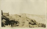
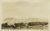
Cliffs of Waweap capped with Dakota. East side Dry Valley looking North. Top of Kaiparowits Plateau in distance. Kane County, UT. 1924 | P0013 Herbert E. Gregory Photograph Collection | P0013n09_010_1739 |
| 148 |
 |
General view walls of Dry Valley, Kane County, UT 1924 | P0013 Herbert E. Gregory Photograph Collection | P0013n09_010_1740 |
| 149 |
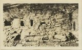 |
Cliff House, Fable Valley (Fred Lowrey, Honolulu) | P0013 Herbert E. Gregory Photograph Collection | P0013n09_145_1996 |
| 150 |
 |
Cliff House, Fable Valley (Fred Lowrey, Honolulu) | P0013 Herbert E. Gregory Photograph Collection | P0013n09_145_1997 |