|
|
Title | Collection Number And Name | Photo Number |
| 26 |
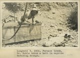 |
Longwell 9, Furnace Creek. Dr. Noble takes a bath in wayside water trough | P0013 Herbert E. Gregory Photograph Collection | P0013n08_188_1711 |
| 27 |
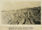 |
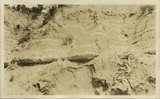
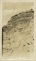
Longwell 10, Furnace Creek. Erosion in colored Tertiary beds | P0013 Herbert E. Gregory Photograph Collection | P0013n08_188_1712 |
| 28 |
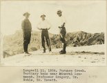 |
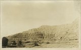
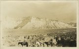
Longwell 11, Furnace Creek. Tertiary beds near Mineral Monument. Professor Gregory, Dr. Noble, Dr. Hewett | P0013 Herbert E. Gregory Photograph Collection | P0013n08_189_1713 |
| 29 |
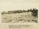 |
Longwell 12, Death Valley. Furnace Creek Ranch. 20-Mule Team Borax wagons | P0013 Herbert E. Gregory Photograph Collection | P0013n08_189_1714 |
| 30 |
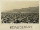 |
Longwell 13, Death Valley salt deposits, 9 miles south of Furnace Creek Ranch | P0013 Herbert E. Gregory Photograph Collection | P0013n08_190_1715 |
| 31 |
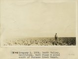 |
Death Valley, California. Salt floor 9 miles south of Furnace Creek Ranch | P0013 Herbert E. Gregory Photograph Collection | P0013n08_191_1716 |
| 32 |
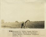 |
Gregory 2, 1924. Death Valley, California. Field at Furnace Creek Ranch. Professor Longwell packing up | P0013 Herbert E. Gregory Photograph Collection | P0013n08_191_1717 |
| 33 |
 |
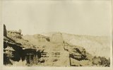
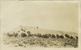
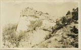
Gregory 3, 1924. Panamint Range, California. View in Wood(?) Valley, next valley south of Harrisburg. Old surface covered with slate fragments | P0013 Herbert E. Gregory Photograph Collection | P0013n08_192_1718 |
| 34 |
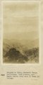 |
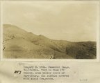
Panamint Range, California. View looking into Death Valley from head of Wood(?) Valley | P0013 Herbert E. Gregory Photograph Collection | P0013n08_192_1719 |
| 35 |
 |
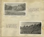
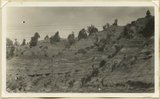
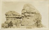
Searles Lake, California. Columns of tufa south end of Searles Lake | P0013 Herbert E. Gregory Photograph Collection | P0013n08_193_1720 |
| 36 |
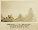 |
Searles Lake, California. Columns of tufa south end of Searles Lake. Marks water level of ancient lake | P0013 Herbert E. Gregory Photograph Collection | P0013n08_193_1721 |
| 37 |
 |
Herbert E. Gregory Book 9: Utah, California, 1924-1928 | P0013 Herbert E. Gregory Photograph Collection | P0013n09 |
| 38 |
 |
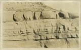
Limestone in 'Marine Jurassic' at a dry waterfall tributary to Virgin River, 2 miles SW of Mt. Carmel | P0013 Herbert E. Gregory Photograph Collection | P0013n09_001_1722 |
| 39 |
 |
Banded, friable sands, 'Marine Jurassic' between limestone bed and gypsum, 2 miles SW of Mt. Carmel | P0013 Herbert E. Gregory Photograph Collection | P0013n09_001_1723 |
| 40 |
 |
Banded, friable sands, 'Marine Jurassic' between limestone bed and gypsum, 2 miles SW of Mt. Carmel | P0013 Herbert E. Gregory Photograph Collection | P0013n09_002_1724 |
| 41 |
 |
Banded red and white sands. 'Marine Jurassic', immediately west of Cannonville | P0013 Herbert E. Gregory Photograph Collection | P0013n09_002_1725 |
| 42 |
 |
Banded red and white sands. 'Marine Jurassic', immediately west of Cannonville | P0013 Herbert E. Gregory Photograph Collection | P0013n09_003_1726 |
| 43 |
 |
Banded red and white sands. 'Marine Jurassic', immediately west of Cannonville | P0013 Herbert E. Gregory Photograph Collection | P0013n09_004_1727 |
| 44 |
 |
Banded red and white sands. 'Marine Jurassic', immediately west of Cannonville | P0013 Herbert E. Gregory Photograph Collection | P0013n09_005_1728 |
| 45 |
 |
Sandstone and shale, 'Marine Jurassic'. Wall of Paria River, 3 miles below Cannonville | P0013 Herbert E. Gregory Photograph Collection | P0013n09_005_1729 |
| 46 |
 |
Ripple-marked sandstone, Marine Jurassic, from bed 40 feet above top of Navajo sandstone, Rock Spring Gulch, 6 miles below Cannonville. S.S. Johnson, packer, in foreground | P0013 Herbert E. Gregory Photograph Collection | P0013n09_005_1730 |
| 47 |
 |
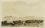
General view, wall of Dry Valley, 'Marine Jurassic', with Dakota top. Kane County, UT. 1924 | P0013 Herbert E. Gregory Photograph Collection | P0013n09_006_1731 |
| 48 |
 |
Banded shales with 3 beds of gypsum, 'Marine Jurassic,' Cottonwood Wash section. Kane County, UT, 1924 | P0013 Herbert E. Gregory Photograph Collection | P0013n09_006_1732 |
| 49 |
 |
Contact McElmo and Dakota, Henrieville Wash. Garfield County, UT, 1924 | P0013 Herbert E. Gregory Photograph Collection | P0013n09_007_1733 |
| 50 |
 |
Cannonville, UT, looking east. September, 1924 | P0013 Herbert E. Gregory Photograph Collection | P0013n09_007_1734 |