Home
Browse
Ask Us
Chat
Harmful Language Statement
Log in
Photo Archives
Advanced Search
About
Over 70,000 photos covering a variety of topics from Marriott Library Special Collections
Year
1875
1876
1877
1878
1879
1880
1881
1882
1883
1884
1885
1886
1887
1888
1889
1890
1891
1892
1893
1894
1895
1896
1897
1898
1899
1900
1901
1902
1903
1904
1905
1906
1907
1908
1909
1910
1911
1912
1913
1914
1915
1916
1917
1918
1919
1920
1921
1922
1923
1924
1925
1926
1927
1928
1929
1930
1931
1932
1933
1934
1935
1936
1937
1938
TO
1875
1876
1877
1878
1879
1880
1881
1882
1883
1884
1885
1886
1887
1888
1889
1890
1891
1892
1893
1894
1895
1896
1897
1898
1899
1900
1901
1902
1903
1904
1905
1906
1907
1908
1909
1910
1911
1912
1913
1914
1915
1916
1917
1918
1919
1920
1921
1922
1923
1924
1925
1926
1927
1928
1929
1930
1931
1932
1933
1934
1935
1936
1937
1938
Type
Image
93
Format
image/jpeg
90
application/pdf
3
Collection Name
Herbert E. Gregory
93
Filters:
Collection Name:
"Herbert E. Gregory"
Date:
"1924"
Collection:
"uum_map"
1
-
25
of
93
<
1
2
3
4
>
Gallery view
Number of results to display per page
10
25
50
100
200
Sort by Relevance
Sort by Title A-Z
Sort by Title Z-A
Sort by Date Ascending
Sort by Date Descending
Sort by Last Modified Ascending
Sort by Last Modified Descending
Sort by Photo Number
Title
Collection Number And Name
Photo Number
1
Herbert E. Gregory Book 8: Arizona, Utah, Nevada, California, 1915-1922
P0013 Herbert E. Gregory Photograph Collection
P0013n08
2
Wingate Pass from Panamint Valley
P0013 Herbert E. Gregory Photograph Collection
P0013n08_176_1687
3
View northward across valley of Wingate Wash from Hidden Spring, Paramint Mountains in background. Low hills upturned Tertiary Lake beds in foreground contain the Epsomite deposits
P0013 Herbert E. Gregory Photograph Collection
P0013n08_177_1688
4
Epsomite deposits associated with Tertiary lake beds 4 miles south of Wingate Wash
P0013 Herbert E. Gregory Photograph Collection
P0013n08_177_1689
5
Epsomite deposits in tertiary lake Beds 4 miles south of Wingate Wash
P0013 Herbert E. Gregory Photograph Collection
P0013n08_178_1690
6
Looking N at Slate Range from 3200 ft. hill of fault breccia situated about 4 miles WSW of 2021 BM in Leach Trough at entrance of Paramint Valley. Outcrop of fault breccia in lower foreground
P0013 Herbert E. Gregory Photograph Collection
P0013n08_178_1691
7
Looking E along Leach Trough from 3200 ft. hill of fault breccia situated about 4 miles WSW of 2021 BM in Leach Trough at entrance of Paramint Valley
P0013 Herbert E. Gregory Photograph Collection
P0013n08_179_1692
8
Looking westward from Cave Spring Wash along fault that crosses Cave Spring Wash at a point 5 miles below Cave Spring. The fault is probably the Leach Trough fault. Rocks at right of fault are indurated coarse red fanglomerate (possibly base of niter bed series); rocks at left are sheared and broden biotite gneiss
P0013 Herbert E. Gregory Photograph Collection
P0013n08_179_1693
9
Mud cracks in a stream channel on the lower part of the fan of Cave Spring Wash, South Death Valley
P0013 Herbert E. Gregory Photograph Collection
P0013n08_180_1694
10
Indurated red fanglomerate lying against fault that crosses Cafe Spring wash at a point 5 miles below Cave Spring; 1696.
P0013 Herbert E. Gregory Photograph Collection
P0013n08_180_1695
11
South end of Silurian Mountains from a point about a mile east of Riggs
P0013 Herbert E. Gregory Photograph Collection
P0013n08_181_1696
12
Silurian Dry Lake and north face of the Avanatz Mountains from mine in Silurian Mountains east of Riggs
P0013 Herbert E. Gregory Photograph Collection
P0013n08_181_1697
13
View across old outflow channel of Silver Lake
P0013 Herbert E. Gregory Photograph Collection
P0013n08_182_1698
14
Old outflow channel of Silver Lake looking south from a point 100 yards north of the divide, showing bedrock (granite) at the left in the bed of the channel. Cut where Gregory is standing is an artificial cut
P0013 Herbert E. Gregory Photograph Collection
P0013n08_182_1699
15
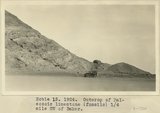
Outcrop of Paleozoic limestone (fossils) 1/4 mile SW of Baker
P0013 Herbert E. Gregory Photograph Collection
P0013n08_183_1700
16
Folded gypsum-bearing beds in east bank of Little Rock Creek near San Andreas Rift, Elizabeth Lake Quadrangle
P0013 Herbert E. Gregory Photograph Collection
P0013n08_183_1701
17
Fault between gypsum-bearing beds and granite in San Andreas Rift Zone on east side of Little Rock Creek, Elizabeth Lake Quadrangle. Fault plane nearly vertical
P0013 Herbert E. Gregory Photograph Collection
P0013n08_183_1702
18
Longwell 1, Charleston Peak at about 11,000 feet
P0013 Herbert E. Gregory Photograph Collection
P0013n08_184_1703
19
Longwell 2, Charleston Peak viewed from the south
P0013 Herbert E. Gregory Photograph Collection
P0013n08_184_1704
20
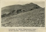
Longwell 3, 1924. Charleston Peak Frost blocks, summit peak in distance
P0013 Herbert E. Gregory Photograph Collection
P0013n08_185_1705
21
Longwell 4, Charleston Peak, frost blocks and vegetation. Dr. L.F. Noble standing
P0013 Herbert E. Gregory Photograph Collection
P0013n08_185_1706
22
Longwell 5, Charleston Peak looking south from summit
P0013 Herbert E. Gregory Photograph Collection
P0013n08_186_1707
23
Longwell 6, 1924. Charleston Peak. Summit. Dr. Noble and Professor Gregory
P0013 Herbert E. Gregory Photograph Collection
P0013n08_186_1708
24
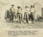
Longwell 7, 1924. Shoshone, Amoragosa Valley. Professor Gregory, Rocky Mountain George, Dr. Noble, Dr. Hewett
P0013 Herbert E. Gregory Photograph Collection
P0013n08_187_1709
25
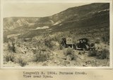
Longwell 8, 1924. Furnace Creek. View near Ryan
P0013 Herbert E. Gregory Photograph Collection
P0013n08_187_1710
1
-
25
of
93
<
1
2
3
4
>