Home
Browse
Ask Us
Chat
Harmful Language Statement
Log in
Advanced Search
Year
1870
1871
1872
1873
1874
1875
1876
1877
1878
1879
1880
1881
1882
1883
1884
1885
1886
1887
1888
1889
1890
1891
1892
1893
1894
1895
1896
1897
1898
1899
1900
1901
1902
1903
1904
1905
1906
1907
1908
1909
1910
1911
1912
1913
1914
1915
1916
1917
1918
1919
1920
1921
1922
1923
1924
1925
1926
1927
1928
1929
1930
1931
1932
1933
1934
1935
1936
1937
1938
1939
1940
1941
1942
1943
1944
1945
1946
1947
1948
1949
1950
1951
1952
1953
1954
1955
1956
1957
1958
1959
1960
1961
1962
1963
1964
1965
1966
1967
1968
1969
1970
1971
1972
1973
1974
1975
1976
1977
1978
1979
1980
1981
1982
1983
1984
1985
1986
1987
1988
1989
1990
1991
1992
1993
1994
1995
1996
1997
1998
1999
2000
2001
2002
2003
2004
2005
2006
2007
2008
2009
2010
2011
2012
2013
2014
2015
2016
2017
2018
2019
TO
1870
1871
1872
1873
1874
1875
1876
1877
1878
1879
1880
1881
1882
1883
1884
1885
1886
1887
1888
1889
1890
1891
1892
1893
1894
1895
1896
1897
1898
1899
1900
1901
1902
1903
1904
1905
1906
1907
1908
1909
1910
1911
1912
1913
1914
1915
1916
1917
1918
1919
1920
1921
1922
1923
1924
1925
1926
1927
1928
1929
1930
1931
1932
1933
1934
1935
1936
1937
1938
1939
1940
1941
1942
1943
1944
1945
1946
1947
1948
1949
1950
1951
1952
1953
1954
1955
1956
1957
1958
1959
1960
1961
1962
1963
1964
1965
1966
1967
1968
1969
1970
1971
1972
1973
1974
1975
1976
1977
1978
1979
1980
1981
1982
1983
1984
1985
1986
1987
1988
1989
1990
1991
1992
1993
1994
1995
1996
1997
1998
1999
2000
2001
2002
2003
2004
2005
2006
2007
2008
2009
2010
2011
2012
2013
2014
2015
2016
2017
2018
2019
Type
Image/StillImage
4,203
Format
image/jpeg
4,093
application/pdf
109
Collection
Photo Archives
154
Regional History Center
1,959
Thorne Photographs
1,454
UAIDA Main Collection
14
Uintah County Regional History Center...
207
Utah River Running Photo Archives
111
Vernal Express Photographs
304
More
Filters:
Spatial Coverage:
"Uintah County (Utah)"
Type:
"Image/StillImage"
1
-
25
of
4,203
<
1
2
3
4
5
6
7
8
9
10
>
Gallery view
Number of results to display per page
10
25
50
100
200
Sort by Relevance
Sort by Title A-Z
Sort by Title Z-A
Sort by Date Ascending
Sort by Date Descending
Sort by Last Modified Ascending
Sort by Last Modified Descending
Title
Date
Type
Setname
1
"Burial of a zombie" Green River, May 1963
1963-05
Image/StillImage
uum_map_rr
2
"Zombie's return" Green River, May 1963
1963-05
Image/StillImage
uum_map_rr
3
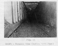
(Fig. 11) "Drift-Bonanza Mine (Before 1945 fire)."
1940; 1941; 1942; 1943; 1944; 1945
Image/StillImage
uum_map
4
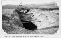
(Fig. 11) "The Bandana Mine on the Cowboy Vein."
1934
Image/StillImage
uum_map
5
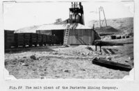
(Fig. 12) "The melt plant of the Pariette Mining Company."
1934
Image/StillImage
uum_map
6
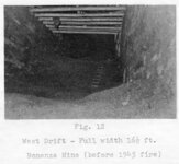
(Fig. 12) "West drift - Full width 16½ ft. [at] Bonanza Mine (before 1945 fire)."
1940; 1941; 1942; 1943; 1944; 1945
Image/StillImage
uum_map
7
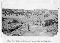
(Fig. 13) "Looking northwest along the Rainbow vein."
1934
Image/StillImage
uum_map
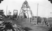
8
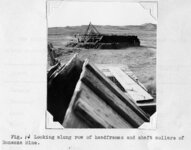
(Fig. 14) "Looking along row of headframes and shaft collars of Bonanza Mine."
1934
Image/StillImage
uum_map
9
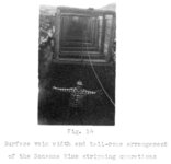
(Fig. 14) "Surface vein width and tail-rope arrangement of the Bonanza Mine stripping operations".
1949
Image/StillImage
uum_map
10
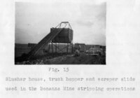
(Fig. 15) "Slusher house, truck hopper and scraper slide used in the Bonanza Mine stripping operations."
1949
Image/StillImage
uum_map
11
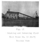
(Fig. 16) "Crushing and Screening Plant, Head Frame No. 14 Shaft, Bonanza Mine."
1949
Image/StillImage
uum_map
12
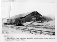
(Fig. 16.) "Ore from American Asphalt Association Mines awaiting shipment at Dragon, Utah."
1934
Image/StillImage
uum_map
13
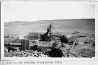
(Fig. 2) "Old workings along Culmer vein"
1934
Image/StillImage
uum_map
14
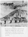
(Fig. 2) "The evolution of gilsonite transportation showing the original mule teams, the old Uintah Railroad from Mack, Colorado, to Watson, Utah, and the modern truck transportation."
1949
Image/StillImage
uum_map
15
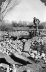
(Fig. 24a) "A prospect pit on the Stacey reed Lease sunk in search of the Fort Duchesne vein, hidden beneath the mantle of boulders and river gravel from the Uinta River. The man inspecting the pit is Harry Pearson, one of the stockholders of the Western Gilsonite and Elaterite Company."
1949
Image/StillImage
uum_map
16
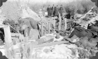
(Fig. 24b) "Wayne Thomas, mining engineer in charge, and a party of visitors inspecting preparations for pouring the concrete for the retaining wall to hold out surface water and sand until a reinforced [sic] concrete collar could be constructed on the bed-rock [sic] about 15 feet below the surface. Note several sacks of gilsonite salvaged from the vein in order to make room for the shaft collar."
1940
Image/StillImage
uum_map
17
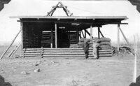
(Fig. 25a) "West view of Arrowchis Shaft showing head frame, loading platform (walled in on windward sides), simple built-in screening plant a rack of sacked gilsonite, and two stockholders, R. L. Hedrick (left), and Harry Pearson. The upper deck served as a protective shed for the loading platform and as a floor to hold each digger's sacks, as they were hoisted from the stopes, until they were sorted, graded, and screened, after which they were racked on the loading platform below for shipment."
1940
Image/StillImage
uum_map
18
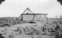
(Fig. 25b) "North view of Arrowchis Shaft of the Western Gilsonite and Elaterite Company, showing four-pole construction of simple head frame. Note mine timber and bath-house (to left and beyond shed). Clothes-line and small building to right of shed are just west of Superintendent's house hidden by the head frame and loading shed."
1940
Image/StillImage
uum_map
19
(Fig. 26a) "View from edge of River Terrace looking southeast along the strike fo the Fort Duchesne Vein toward the Arrowchis Lease from near the point of original discovery of this vein, just northwest of the commercial portion of the vein. Over the top of the house in the center can be seen the dim outline of a string of headframes (including those in "B" below) over the closely-spaced shafts of the Raven Mining Company."
1940
Image/StillImage
uum_map
20
(Fig. 26b) "Headframes over tow chief shafts on the Raven Mining Company's portion of the Fort Duchesne vein. These shafts were deepened and somewhat modernized to service the lower levels. The shafts between, and on either side were then abandoned. Note hand screening equipment, power line, and slabs for lagging the ming."
1940
Image/StillImage
uum_map
21
(Fig. 28) "Two views of the head-frame of the Stacey Reed shaft, taken from near the south boundary of the Arrowchis Lease of the Western Gilsonite and Elaterite Company, and from a point approximately where it is proposed to sink the new two-compartment deep shaft for pemanent commercial production. The Stacey Reed shaft here shown will serve as auxiliary manway and airway for the new shaft of the Western Gilsonite and Elaterite Company by permitting this use of their shaft, and will bear their share of the hoisting and drifting necessary to make the connection. As explained in the text, the overhead thus saved will be of vital importance to all concerned. Note the rick of sacked gilsonite near the shaft. The discovery of commercial gilsonite at this point on the vein beyond the boundary line of the Arrowchis Lease proved beyond question the ‘ore' body throughout the full length of the lease."
1940
Image/StillImage
uum_map
22
(Fig. 28) "Two views of the head-frame of the Stacey Reed shaft, taken from near the south boundary of the Arrowchis Lease of the Western Gilsonite and Elaterite Company, and from a point approximately where it is proposed to sink the new two-compartment deep shaft for pemanent commercial production. The Stacey Reed shaft here shown will serve as auxiliary manway and airway for the new shaft of the Western Gilsonite and Elaterite Company by permitting this use of their shaft, and will bear their share of the hoisting and drifting necessary to make the connection. As explained in the text, the overhead thus saved will be of vital importance to all concerned. Note the rick of sacked gilsonite near the shaft. The discovery of commercial gilsonite at this point on the vein beyond the boundary line of the Arrowchis Lease proved beyond question the ‘ore' body throughout the full length of the lease."
1940
Image/StillImage
uum_map
23
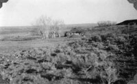
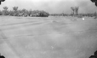
(Fig. 29a) "Winter scene looking southwestward from a point approximately where it is proposed to sink the new two-compartment shaft of the Western Gilsonite and Elaterite Company. The fence running west from the clump of buffalo-berry bushes in the center of the photograph is the southern boundary of the Arrowchis Lease, and the point where this fence line leaves the picture at the extreme right is where the connection will be made with the power line of the Uinta Power and Light Company."
1940
Image/StillImage
uum_map
24
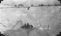
(Fig. 29b) "Looking northwest along the strike of the Fort Duchesne vein from the Stacey Reed shaft. Almost the entire Arrowchis Lease can be seen on this picture. The fence posts in the foreground mark the southern boundary. The brush line beyond the Arrowchis shaft is where the vein passes beyond its northwest boundary. The men are ‘warming up' the gasoline hoist for the Stacey Reed shaft. Obviously, they need a hoist house."
1940
Image/StillImage
uum_map
25
(Fig. 4) "Looking southeast along Cowboy Vein, Uinta Sandstones in the foreground, the Green River Shales in the distance."
1934
Image/StillImage
uum_map
1
-
25
of
4,203
<
1
2
3
4
5
6
7
8
9
10
>