| Title | Date | Type | Setname | ||
|---|---|---|---|---|---|
| 451 |
 | Santa Fe, New Mexico P.6 | Image | dha_cp | |
| 452 |
 | Scene on the reservation a typical Navajo cornfield | 1880; 1881; 1882; 1883; 1884; 1885; 1886; 1887; 1888; 1889; 1890; 1891; 1892; 1893; 1894; 1895; 1896; 1897; 1899; 1900; 1901; 1902; 1903; 1904; 1905; 1906; 1907; 1908; 1909; 1910 | Image/StillImage | uaida_main |
| 453 |
 | Scott Veenis [01] | 2007-02-09; 2007-02-10; 2008-02-08 | Image/StillImage | uum_map_usa |
| 454 |
 | Scott Veenis [02] | 2007-02-09; 2007-02-10; 2008-02-08 | Image/StillImage | uum_map_usa |
| 455 |
 | Scott Veenis [03] | 2007-02-09; 2007-02-10; 2008-02-08 | Image/StillImage | uum_map_usa |
| 456 |
 | Scott Veenis [04] | 2007-02-09; 2007-02-10; 2008-02-08 | Image/StillImage | uum_map_usa |
| 457 |
 | Scott Veenis [05] | 2007-02-09; 2007-02-10; 2008-02-08 | Image/StillImage | uum_map_usa |
| 458 |
 | Scott Veenis [06] | 2007-02-09; 2007-02-10; 2008-02-08 | Image/StillImage | uum_map_usa |
| 459 |
 | Scott Veenis [07] | 2007-02-09; 2007-02-10; 2008-02-08 | Image/StillImage | uum_map_usa |
| 460 |
 | Scott Veenis [08] | 2007-02-09; 2007-02-10; 2008-02-08 | Image/StillImage | uum_map_usa |
| 461 |
 | Scott Veenis [09] | 2007-02-09; 2007-02-10; 2008-02-08 | Image/StillImage | uum_map_usa |
| 462 |
 | Scott Veenis, Eva Huckova | 2007-02-09; 2007-02-10; 2008-02-08 | Image/StillImage | uum_map_usa |
| 463 |
 | Sean Mckenna | 2007-02-09; 2007-02-10; 2008-02-08 | Image/StillImage | uum_map_usa |
| 464 |
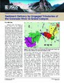 | Sediment Delivery by Ungaged Tributaries of the Colorado River in Grand Canyon | 2001 | Text | wwdl_er |
| 465 |
 | Selected hydrologic data for the upper Rio Hondo basin, Lincoln County, New Mexico, 1945-2003 | 2004 | Text | wwdl_er |
| 466 |
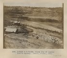 | Sheep Dip of Pueblo Bonito agency. Heald, photo. 1911 (Photo N-M132 & N-M132a) | 1911 | Image | uum_map |
| 467 |
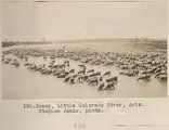 | Sheep, Little Colorado River, Ariz. Stephen Janus, photo. | 1909 | Image | uum_map |
| 468 |
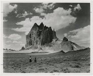
 | Ship Rock [Z-3701] | 1930; 1931; 1932; 1933; 1934; 1935; 1936; 1937; 1938; 1939; 1940; 1941; 1942; 1942; 1943; 1944; 1945 | Image/StillImage | uaida_main |
| 469 |
 | Ship Rock [Z-3701] | 1930; 1931; 1932; 1933; 1934; 1935; 1936; 1937; 1938; 1939; 1940; 1941; 1942; 1942; 1943; 1944; 1945 | Image/StillImage | uaida_main |
| 470 |
 | Shiprock | 1945; 1946; 1947; 1948; 1949; 1950; 1951; 1952; 1953; 1954; 1955; 1956; 1957; 1958; 1959; 1960; 1961; 1962; 1963; 1964; 1965 | Image | uum_map |
| 471 |
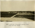 | Shiprock Agency from mesa on the north | 1913 | Image | uum_map |
| 472 |
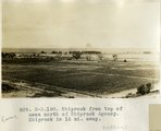 | Shiprock from top of mesa north of Shiprock Agency. Shiprock is 16 mi. away. | 1913 | Image | uum_map |
| 473 |
 | Shiprock, New Mexico - aerial view | 1937; 1938; 1939; 1940; 1941; 1942; 1943; 1944; 1945; 1946; 1947; 1948; 1949; 1950; 1951; 1952; 1953; 1954; 1955; 1956; 1957; 1958; 1959; 1960; 1961; 1962; 1963; 1964; 1965; 1966; 1967; 1968; 1969; 1970; 1971; 1972; 1973; 1974; 1975; 1976; 1977; 1978; 1979; 1980 | Image | uum_map_rr |
| 474 |
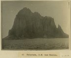 | Shiprock, NW New Mexico | 1915 | Image | uum_map |
| 475 |
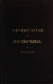 | The shortest route to California illustrated by a history of explorations of the Great Basin of Utah with its topographical and geological character and some account of the Indian tribes | Text | uaida_main |