Home
Browse
Ask Us
Chat
Harmful Language Statement
Log in
American Westward Migration
Advanced Search
About
Diaries, maps and trails of Mormon pioneers and their westward migration in the 1850s. Diaries include Joseph C. Kingsbury, George A. Thomas, John B. Fairbanks, Joseph A. Young, and Lucia Lamb Everett.
Year
1838
1839
1840
1841
1842
1843
1844
1845
1846
1847
1848
1849
1850
1851
1852
1853
1854
1855
1856
1857
1858
1859
1860
1861
1862
1863
1864
1865
1866
1867
1868
1869
1870
1871
1872
1873
1874
1875
1876
1877
1878
1879
1880
1881
1882
1883
1884
1885
1886
1887
1888
1889
1890
1891
1892
1893
1894
1895
1896
1897
1898
1899
TO
1838
1839
1840
1841
1842
1843
1844
1845
1846
1847
1848
1849
1850
1851
1852
1853
1854
1855
1856
1857
1858
1859
1860
1861
1862
1863
1864
1865
1866
1867
1868
1869
1870
1871
1872
1873
1874
1875
1876
1877
1878
1879
1880
1881
1882
1883
1884
1885
1886
1887
1888
1889
1890
1891
1892
1893
1894
1895
1896
1897
1898
1899
Type
Image/StillImage
34
Text
22
Image/MovingImage
5
Image
2
Format
image/jpeg
41
application/pdf
22
Collection
American Westward Migration
63
Filters:
Collection:
"uu_awm"
26
-
50
of
63
<
1
2
3
>
Gallery view
Number of results to display per page
10
25
50
100
200
Sort by Relevance
Sort by Title A-Z
Sort by Title Z-A
Sort by Date Ascending
Sort by Date Descending
Sort by Last Modified Ascending
Sort by Last Modified Descending
Title
Date
Type
26
Diary of Joseph A. Young
1864
Text
27
Diary of Joseph C. Kingsbury
1846; 1847; 1848; 1849; 1850; 1851; 1852; 1853; 1854; 1855; 1856; 1857; 1858; 1859; 1860; 1861; 1862; 1863; 1864; 1865; 1866; 1867; 1868; 1869; 1870; 1871; 1872; 1873; 1874; 1875; 1876; 1877; 1878; 1879; 1880; 1881; 1882; 1883; 1884; 1885; 1886; 1887; 1888; 1889; 1890; 1891; 1892; 1893
Text
28
Diary of Lucia Eugenia Lamb Everett
1862
Text
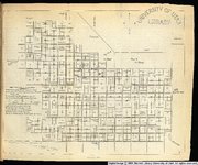
29
Great Salt Lake City surveys platted for Cap. Richard F. Burton. by Bullock, Thomas.
1860
Image/StillImage
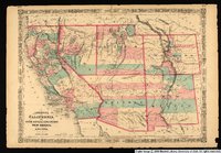
30
Johnson's California, with Utah, Nevada, Colorado, New Mexico, and Arizona.
1864
Image/StillImage
31
Karte zu Balduin Mollhausen's Reise vom Mississippi nach der Kuste der Sudsee im Jahre 1853-1854
1854
Image/StillImage
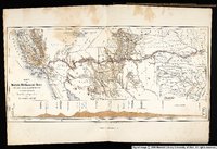
32
Map Exhibiting the Lines of March Passed Over by the Troops of the United States During the Year Ending June 30th 1858
1858
Image
33
Map exhibiting the lines of march passed over by the troops of the United States during the year ending June 30th 1858.
1858
Image/StillImage
34
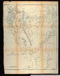
Map exhibiting the routes between Fort Dalles and the Great Salt Lake.
1859
Image/StillImage
35
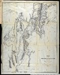
Map no. 2, from the Great Salt Lake to the Humboldt Mountains.
1855
Image/StillImage
36
Map no. 2, from the mouth of Trap Creek to the Santa Fe crossing.
1855
Image/StillImage
37
Map No. 2, Riviere des Lacs to the Rocky Mountains.
1854
Image/StillImage
38
Map no. 3 from the Santa Fe crossing to the Coo-Che-to-pa Pass.
1855
Image/StillImage
39
Map no. 3, Rocky Mountains to Puget Sound.
1855
Image/StillImage
40
Map of an exploring expedition to the Rocky Mountains in the year 1842 and to Oregon & North California in the years 1843-4
1845
Image/StillImage
41
Map of an exploring expedition to the Rocky Mountains in the year 1842 and to Oregon & North California in the years 1843-44
1845
Image/StillImage
42
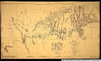
Map of explorations and surveys in New Mexico and Utah
1860
Image/StillImage
43
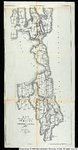
Map of the Great Salt Lake and adjacent country in the Territory of Utah ; The Great Salt Lake (Mormon) City and surrounding country : (on an enlarged scale)
1863
Image/StillImage
44
Map of the Great Salt Lake and adjacent country in the territory of Utah.
1850
Image/StillImage
45
Map of the Great Salt Lake and adjacent country in the territory of Utah.
1852
Image/StillImage
46
Map of the Territory of New Mexico
1850
Image/StillImage
47
Map of the Territory of New Mexico made by order of Brig. Gen. S.W. Kearny, under instructions from Lieut. W.H. Emory
1848
Image/StillImage
48
Map of wagon routes in Utah Territory explored and opened by Capt. J. H. Simpson...in 1858-59.
1859
Image/StillImage
49
Map showing the different routes travelled over by the detachments of the Overland Command in the spring of 1855 from Salt Lake City, Utah, to the Bay of San Francisco.
1855
Image/StillImage
50
Map showing the extent of surveys in the territory of Utah, 1856.
1856
Image/StillImage
26
-
50
of
63
<
1
2
3
>