Home
Browse
Ask Us
Chat
Harmful Language Statement
Log in
Advanced Search
Year
1849
1850
1851
1852
1853
1854
1855
1856
1857
1858
1859
1860
1861
1862
1863
1864
1865
1866
1867
1868
1869
1870
1871
1872
1873
1874
1875
1876
1877
1878
1879
1880
1881
1882
1883
1884
1885
1886
1887
1888
1889
1890
1891
1892
1893
1894
1895
1896
1897
1898
1899
1900
1901
1902
1903
1904
1905
1906
1907
1908
1909
1910
1911
1912
1913
1914
1915
1916
1917
1918
1919
1920
1921
1922
1923
1924
1925
1926
1927
1928
1929
1930
1931
1932
1933
1934
1935
1936
1937
1938
1939
1940
1941
1942
1943
1944
1945
1946
1947
1948
1949
1950
1951
1952
1953
1954
1955
1956
1957
1958
1959
1960
1961
1962
1963
1964
1965
1966
1967
1968
1969
1970
1971
1972
1973
1974
1975
1976
1977
1978
1979
1980
1981
1982
1983
1984
1985
1986
1987
1988
1989
1990
1991
1992
1993
1994
1995
1996
1997
1998
1999
2000
2001
2002
2003
2004
2005
2006
2007
2008
2009
2010
2011
2012
2013
2014
2015
2016
2017
2018
2019
2020
2021
2022
2023
TO
1849
1850
1851
1852
1853
1854
1855
1856
1857
1858
1859
1860
1861
1862
1863
1864
1865
1866
1867
1868
1869
1870
1871
1872
1873
1874
1875
1876
1877
1878
1879
1880
1881
1882
1883
1884
1885
1886
1887
1888
1889
1890
1891
1892
1893
1894
1895
1896
1897
1898
1899
1900
1901
1902
1903
1904
1905
1906
1907
1908
1909
1910
1911
1912
1913
1914
1915
1916
1917
1918
1919
1920
1921
1922
1923
1924
1925
1926
1927
1928
1929
1930
1931
1932
1933
1934
1935
1936
1937
1938
1939
1940
1941
1942
1943
1944
1945
1946
1947
1948
1949
1950
1951
1952
1953
1954
1955
1956
1957
1958
1959
1960
1961
1962
1963
1964
1965
1966
1967
1968
1969
1970
1971
1972
1973
1974
1975
1976
1977
1978
1979
1980
1981
1982
1983
1984
1985
1986
1987
1988
1989
1990
1991
1992
1993
1994
1995
1996
1997
1998
1999
2000
2001
2002
2003
2004
2005
2006
2007
2008
2009
2010
2011
2012
2013
2014
2015
2016
2017
2018
2019
2020
2021
2022
2023
Type
Image/StillImage
2,931
Image
2,504
Text
294
Sound
147
Image/MovingImage
9
Format
image/jpeg
5,249
application/pdf
594
video/mp4
112
audio/mpeg
44
Institution
University of Utah Marriott Library
5,172
Department of Cultural and Community ...
393
University of Utah Partnerships
163
Utah Museum of Natural History
148
Utah American Indian Digital Archive
141
Western Waters Digital Library
40
Delta City Library
6
Uintah County Library
4
More
Collection
Al W. Morton Collection, 1930s-1950s
55
American Westward Migration
3
Audio-Visual Archives Collections
2
Beckwith Photograph Collection
6
Classified Photographs
336
College of Law Publications
1
Everett L. Cooley Oral History Project
1
George A. Smith Papers
1
Glen Canyon
1
Land Use - Transportation Scenario Pl...
4
Mormon Settlement in Arizona
212
Photo Archives
1,942
Shipler Commercial Photographers
2
Ski and Snow Sports Photo Archives
7
UAIDA Main Collection
141
Uintah County Regional History Center...
3
Utah Artists Project
2
Utah Humanities Research Foundation
5
Utah River Running Photo Archives
3,002
Vernal Express Photographs
1
Vertebrate Zoology Field Notes
7
Vertebrate Zoology Voucher Images
141
Western Soundscape
152
Western Waters Documents
2
Western Waters Electronic Resources
38
More
Filters:
Spatial Coverage:
"Arizona"
601
-
625
of
6,067
<
20
21
22
23
24
25
26
27
28
29
>
Gallery view
Number of results to display per page
10
25
50
100
200
Sort by Relevance
Sort by Title A-Z
Sort by Title Z-A
Sort by Date Ascending
Sort by Date Descending
Sort by Last Modified Ascending
Sort by Last Modified Descending
Title
Date
Type
Setname
601
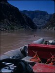
Colorado River trip, summer 1971 [16]
1971
Image/StillImage
uum_map_rr
602
Colorado River trip, summer 1971 [17]
1971
Image/StillImage
uum_map_rr
603
Colorado River, 1962
1962
Image/StillImage
uum_map_rr
604
Colorado River, Grand Canyon, June 1956
1956-06
Image/StillImage
uum_map_rr
605
Column of LaPlata near No. 624 (junction of Chinlee and Carrizo Washes, Photo G330)
1913
Image
uum_map
606
Columns, Zilh-Tusayan, igneous mass, 20± mil. northwest of Fort Defiance, Ariz., 1909 (photo G-21)
1909
Image
uum_map
607
Comb Monocline, 2 miles east of mouth of Sagy, at Marsh Pass, 1914
1914
Image
uum_map
608
Communion on the Colorado, early 1960s
1961; 1962; 1963; 1964; 1965
Image/StillImage
uum_map_rr
609
Computation and analysis of the instantaneous-discharge record for the Colorado River at Lees Ferry, Arizona : May 8, 1921, through September 30, 2000
2003
Text
wwdl_er
610
Concretions (Dakota?), Hlohala, Ariz., 1909 (photo G-106)
1909
Image
uum_map
611
Concretions (Dakota?), Hlohala, Ariz., 1909 (photo G-106)
1909
Image
uum_map
612
Concretions, Hlohala, 1909
1909
Image
uum_map
613
Concretions, Hlohala, 1909
1909
Image
uum_map
614
Cone & flow east of Oak Spring near Vulcans Throne
1900
Image
uum_map
615
Cone near Oak Spring
1900
Image
uum_map
616
Cones near Mt Trumbull, lava in foreground
1900
Image
uum_map
617
Cones, Mt Trumbull
1900
Image
uum_map
618
confluence of Colorado River and Little Colorado River - aerial view
1930; 1931; 1932; 1933; 1934; 1935; 1936; 1937; 1938; 1939; 1940; 1941; 1942; 1943; 1944; 1945; 1946; 1947; 1948; 1949; 1950
Image
uum_map_rr
619
Conglomerate forming part of Black Rock; igneous mass, Ft. Defiance, Ariz., 1909 (photo G-15)
1909
Image
uum_map
620
Congressional Report: Investigation of Indian Frauds dated March 3, 1873
1873-03-03
Image/StillImage
uaida_main
621
Contact Navajo sandstone and McElmo, Blue Canyon, 1914
1914
Image
uum_map
622
Contact, Carboniferous and Permian, Wolf's Crossing (Photo N-M173)
1913
Image
uum_map
623
Contact, McElmo and Mancos, 3 mi. NE of Blue Canyon store, 1914
1914
Image
uum_map
624
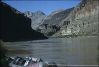
Contact, Moencopie-Shinarump, Mouth of Moencopie (Photo G428)
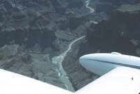
1913
Image
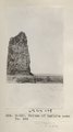
uum_map
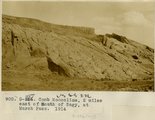
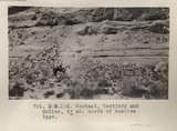
625
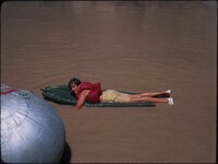
Contact, Tertiary and McElmo, 2± mi. north of Sunrise Spgs. (Photo N-M166)
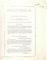
1913
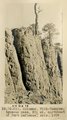
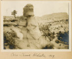
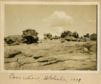
Image
uum_map
601
-
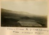
625
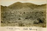
of
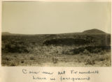
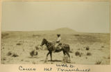
6,067
<
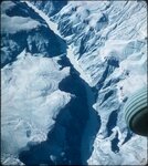
20
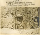
21
22
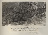
23
24
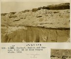
25
26
27
28
29
>