Home
Browse
Ask Us
Chat
Harmful Language Statement
Log in
Advanced Search
Year
1849
1850
1851
1852
1853
1854
1855
1856
1857
1858
1859
1860
1861
1862
1863
1864
1865
1866
1867
1868
1869
1870
1871
1872
1873
1874
1875
1876
1877
1878
1879
1880
1881
1882
1883
1884
1885
1886
1887
1888
1889
1890
1891
1892
1893
1894
1895
1896
1897
1898
1899
1900
1901
1902
1903
1904
1905
1906
1907
1908
1909
1910
1911
1912
1913
1914
1915
1916
1917
1918
1919
1920
1921
1922
1923
1924
1925
1926
1927
1928
1929
1930
1931
1932
1933
1934
1935
1936
1937
1938
1939
1940
1941
1942
1943
1944
1945
1946
1947
1948
1949
1950
1951
1952
1953
1954
1955
1956
1957
1958
1959
1960
1961
1962
1963
1964
1965
1966
1967
1968
1969
1970
1971
1972
1973
1974
1975
1976
1977
1978
1979
1980
1981
1982
1983
1984
1985
1986
1987
1988
1989
1990
1991
1992
1993
1994
1995
1996
1997
1998
1999
2000
2001
2002
2003
2004
2005
2006
2007
2008
2009
2010
2011
2012
2013
2014
2015
2016
2017
2018
2019
2020
2021
2022
2023
TO
1849
1850
1851
1852
1853
1854
1855
1856
1857
1858
1859
1860
1861
1862
1863
1864
1865
1866
1867
1868
1869
1870
1871
1872
1873
1874
1875
1876
1877
1878
1879
1880
1881
1882
1883
1884
1885
1886
1887
1888
1889
1890
1891
1892
1893
1894
1895
1896
1897
1898
1899
1900
1901
1902
1903
1904
1905
1906
1907
1908
1909
1910
1911
1912
1913
1914
1915
1916
1917
1918
1919
1920
1921
1922
1923
1924
1925
1926
1927
1928
1929
1930
1931
1932
1933
1934
1935
1936
1937
1938
1939
1940
1941
1942
1943
1944
1945
1946
1947
1948
1949
1950
1951
1952
1953
1954
1955
1956
1957
1958
1959
1960
1961
1962
1963
1964
1965
1966
1967
1968
1969
1970
1971
1972
1973
1974
1975
1976
1977
1978
1979
1980
1981
1982
1983
1984
1985
1986
1987
1988
1989
1990
1991
1992
1993
1994
1995
1996
1997
1998
1999
2000
2001
2002
2003
2004
2005
2006
2007
2008
2009
2010
2011
2012
2013
2014
2015
2016
2017
2018
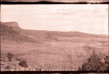
2019
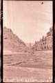
2020
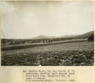
2021
2022
2023
Type
Image/StillImage
2,931
Image
2,504
Text
294
Sound
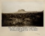
147
Image/MovingImage
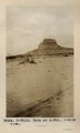
9
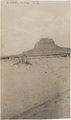
Format
image/jpeg
5,249
application/pdf
594
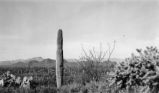
video/mp4
112
audio/mpeg
44
Institution
University of Utah Marriott Library
5,172
Department of Cultural and Community ...
393
University of Utah Partnerships
163
Utah Museum of Natural History
148
Utah American Indian Digital Archive
141
Western Waters Digital Library
40
Delta City Library
6
Uintah County Library
4
More
Collection
Al W. Morton Collection, 1930s-1950s
55
American Westward Migration
3
Audio-Visual Archives Collections
2
Beckwith Photograph Collection
6
Classified Photographs
336
College of Law Publications
1
Everett L. Cooley Oral History Project
1
George A. Smith Papers
1
Glen Canyon
1
Land Use - Transportation Scenario Pl...
4
Mormon Settlement in Arizona
212
Photo Archives
1,942
Shipler Commercial Photographers
2
Ski and Snow Sports Photo Archives
7
UAIDA Main Collection
141
Uintah County Regional History Center...
3
Utah Artists Project
2
Utah Humanities Research Foundation
5
Utah River Running Photo Archives
3,002
Vernal Express Photographs
1
Vertebrate Zoology Field Notes
7
Vertebrate Zoology Voucher Images
141
Western Soundscape
152
Western Waters Documents
2
Western Waters Electronic Resources
38
More
Filters:
Spatial Coverage:
"Arizona"
351
-
375
of
6,067
<
10
11
12
13
14
15
16
17
18
19
>
Gallery view
Number of results to display per page
10
25
50
100
200
Sort by Relevance
Sort by Title A-Z
Sort by Title Z-A
Sort by Date Ascending
Sort by Date Descending
Sort by Last Modified Ascending
Sort by Last Modified Descending
Title
Date
Type
Setname
351
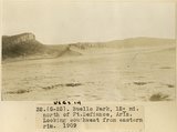
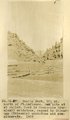
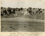
Buells Park, 12± mi. north of Ft. Defiance, Ariz. Looking southwest from eastern rim, 1909 (photo G-25)
1909
Image
uum_map
352
Buells Park, 12± mi. north of Ft. Defiance, Ariz. Looking southwest from eastern rim, 1909 (photo G-25)
1909
Image
uum_map
353
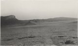
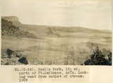
Buells Park, 12± mi. north of Ft. Defiance, Ariz. Looking west from outlet of stream, 1909 (photo G-24)
1909
Image
uum_map
354
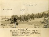
Buells Park, 12± mi. north of Ft. Defiance, Ariz., looking east across park toward Baigaiche Mt., 1909 (photo G-23)
1909
Image
uum_map
355
Buells Park, 12± mi. north of Ft. Defiance. Dam site at outlet. Rock is Moencopie (Permian?) sandstone, capped by Shinarump (Triassic) sandstone and conglomerate, 1909 (photo G-27)
1909
Image
uum_map
356
Buells Park, 12± north of Ft. Defiance, looking east across park from west rim, Baigaiche Mt. in near distance, 1908 (D. B. Sterrett photo USGS)
1908
Image
uum_map
357
Buells Park, 12± north of Ft. Defiance, looking toward west rim. Hill of peridotite bearing gem peridots and garnets in center, 1908 (D. B. Sterrett photo USGS)
1908
Image
uum_map
358
Buells Park, N. Ft. Defiance (negative for photo G-24)
1909
Image
uum_map
359
Buells Park, N. Ft. Defiance (negative for photo G-27)
1909
Image
uum_map
360
Buells Park, north of Fort Defiance, D. B. Sterrett photo USGS, 1908
1908
Image
uum_map
361
Buff-collared Nightjar 1
2009-05-21
Sound
uu_wss
362
Bulletin of the Geological and Geographical Survey of The Territories, Volume II
1876
Text
uaida_main
363
Bunkerville, Arizona School
1913-06-13
Image
dha_scp
364
Burials p.5
1934
Image
dha_cp
365
Burials P.5
Image
dha_cp
366
Burro, Ganado, Ariz. 1909
1909
Image
uum_map
367
Butte, 3± mi. west of Stiles Ranche (Photo G238)
1911
Image
uum_map
368
Butte, 3± mi. west of Stiles Ranche (Photo G238)
1911
Image
uum_map
369
Butte, junction Sagy canyon with middle of East Branch, Ariz., 1910 (Photo G162)
1910
Image
uum_map
370
Butte, LaPlata on Dolores, 12+ mi. south of Oljato, Utah. Agathla Needle and QueenRock in distance, 1910 (Photo G159)
1910
Image
uum_map
371
Butte, LaPlata on Dolores, 12+ mi. south of Oljato, Utah. Agathla Needle in distance, 1910 (Photo N-M91A)
1910
Image
uum_map
372
Butte, LaPlata on Dolores, 12± mi. south of Oljato, Utah. Agathla Needle in distance, 1910
1910
Image
uum_map
373
Butterfly Dance
1938
Image
dc_bpc
374
Cabin in the desert of Arizona [Z-7452]
1910; 1911; 1912; 1913; 1914; 1915; 1916; 1917
Image/StillImage
uaida_main
375
Cacti P.2
1941-03-19
Image
dha_cp
351
-
375
of
6,067
<
10
11
12
13
14
15
16
17
18
19
>