The Federal Resources Corporation records (1930-1989) contain the "dead files" of a company that, through a long series of mergers and acquisitions, most of which took place in the 1960s, became a force in the world of mineral exploration, development, and mining. While the company dealt with the extraction of various metals and minerals over the years including gold, silver, copper, beryllium, and fluorspar, the focus of the materials in this collection is primarily uranium. The collection materials reflect the company's focus on the western states of Alaska, Arizona, California, Idaho, Montana, Nevada, New Mexico, Oregon, Texas, Washington, and, especially, Utah and Wyoming.
1 - 25 of 11
| Title | Date | File Number | ||
|---|---|---|---|---|
| 1 |  | Federal Resources Corporation land map: North Black Hills fairway | 1972-11 | 1513_047B_001_001 |
| 2 |  | Drill holes in Lakota formation, Black Hills, 1971 | 1971-07-13 | 1513_048B_009_002 |
| 3 | 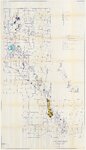 | Federal Resources Corporation Black Hills project: map showing leases and claims with some geology | 1972-11-10 | 1513_049_006_001 |
| 4 | 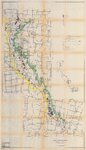 | Federal Resources Corporation Black Hills project: map showing leases and claims with some geology | 1969-12-01 | 1513_049_006_006 |
| 5 | 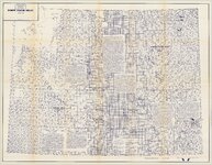 | Wyoming uranium project index map | 1970; 1971; 1972; 1973; 1974; 1975; 1976 | 1513_088_002_001 |
| 6 |  | Scaler vs. radiometrics graph [1] | 1513_49A_009_001 | |
| 7 |  | Scaler vs. radiometrics graph [2] | 1513_49A_009_002 | |
| 8 |  | Federal Resources Corporation Black Hills district: drilling progress map, 1973, July report | 1973-07 | 1513_49A_016_001 |
| 9 |  | Structure contours on top of Morrison Formation | 1513_49A_017_001 | |
| 10 |  | Black Hills and the northeast portion of the Powder River Basin, Montana and Wyoming | 1975-11 | 1513_49A_017_002 |
| 11 | 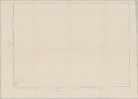 | Scaler vs. radiometrics graph [3] | 1513_49A_017_003 |
1 - 25 of 11