Home
Browse
Ask Us
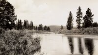
Chat
Harmful Language Statement
Log in
University of Utah Marriott Library
Advanced Search
Year
1933
1934
1935
1936
1937
1938
1939
1940
1941
1942
1943
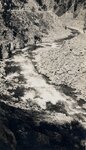
1944
1945
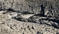
1946
1947
1948
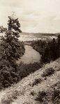
1949
1950
1951
1952
1953
1954
1955
1956
1957
1958
1959
1960
1961
1962
1963
1964
1965
1966
1967
1968
1969
1970
1971
1972
1973
1974
1975
1976
1977
1978
1979
1980
1981
1982
1983
1984
1985
1986
1987
1988
1989
1990
1991
1992
1993
1994
1995
1996
1997
1998
1999
2000
2001
2002
2003
2004
2005
2006
2007
2008
2009
TO
1933
1934
1935
1936
1937
1938
1939
1940
1941
1942
1943
1944
1945
1946
1947
1948
1949
1950
1951
1952
1953
1954
1955
1956
1957
1958
1959
1960
1961
1962
1963
1964
1965
1966
1967
1968
1969
1970
1971
1972
1973
1974
1975
1976
1977
1978
1979
1980
1981
1982
1983
1984
1985
1986
1987
1988
1989
1990
1991
1992
1993
1994
1995
1996
1997
1998
1999
2000
2001
2002
2003
2004
2005
2006
2007
2008
2009
Type
Image
60
Image/StillImage
5
Format
image/jpeg
65
Collection
Ski and Snow Sports Photo Archives
5
Utah River Running Photo Archives
60
Filters:
Spatial Coverage:
"Grand County (Colo.)"
1
-
25
of
65
<
1
2
3
>
Gallery view
Number of results to display per page
10
25
50
100
200
Sort by Relevance
Sort by Title A-Z
Sort by Title Z-A
Sort by Date Ascending
Sort by Date Descending
Sort by Last Modified Ascending
Sort by Last Modified Descending
Title
Date
Type
Setname
1
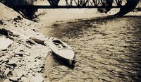
"Rob Roy" at the outlet of Grand Lake
1933
Image
uum_map_rr
2
2008-2009 University of Utah Men's Nordic start at Denver University Invitational. Devil's Thumb, Colorado. February 2009
2009-02
Image/StillImage
uum_map_usa
3
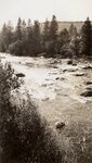
A North Fork meadow
1933
Image
uum_map_rr
4
Above Granby to above Byers Canyon - Above the Arapaho Bridge. River drops 85 feet in a mile, but made this without portage or lining, bumping down through.
1933
Image
uum_map_rr
5
Above Granby to above Byers Canyon - Below Sleepy Hollow, near Trout Rapids
1933
Image
uum_map_rr
6
Above Granby to above Byers Canyon - Colo. R. Near Sleepy Hollow-above S[outh] Fork (2 copies)
1933
Image
uum_map_rr
7
Above Granby to above Byers Canyon - Colorado River above Columbine Cr[eek]
1933
Image
uum_map_rr
8
Above Granby to above Byers Canyon - Colorado River above the Arapaho
1933
Image
uum_map_rr
9
Above Granby to above Byers Canyon - Colorado River above the mouth of the Fraser [River], near Granby
1933
Image
uum_map_rr
10
Above Granby to above Byers Canyon - Confluence of Fraser [River] & Colo. Rivers below Granby, Colo. Looking into Windy Gap.
1933
Image
uum_map_rr
11
Above Granby to above Byers Canyon - Looking upstream into Windy Gap, after thunderstorm. Between Granby and Hot Sulphur Sp[rin]gs.
1933
Image
uum_map_rr
12
Alan's parents, Eunice and Francis Schoenberger, Winter Park 1943
1943
Image/StillImage
uum_map_usa
13
Below Columbine Creek
1933
Image
uum_map_rr
14
Byers Canyon - [ROB ROY in Byers Canyon]
1933
Image
uum_map_rr
15
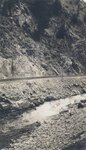
Byers Canyon - Byers Canyon
1933
Image
uum_map_rr
16
Byers Canyon - Byers Canyon
1933
Image
uum_map_rr
17
Byers Canyon - Byers Canyon. Lining boat under big rock on r[ight].
1933
Image
uum_map_rr
18
Byers Canyon - Drying gear below Byers Canyon
1933
Image
uum_map_rr
19
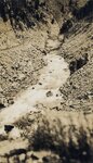
Byers Canyon - Easing down a bad stretch in Byers Canyon
1933
Image
uum_map_rr
20
Byers Canyon - Hard, fast water in Byers Canyon
1933
Image
uum_map_rr
21
Byers Canyon - Lining boat around falls in Byers Canyon.
1933
Image
uum_map_rr
22
Byers Canyon - The worst stretch in Byers Canyon. Lined about 80 yards, ran rest.
1933
Image
uum_map_rr
23
Byers Canyon - Upper Falls in Byers Canyon
1933
Image
uum_map_rr
24
The Colorado at the Grand Lake outlet
1933
Image
uum_map_rr
25
The Colorado River above Granby
1933
Image
uum_map_rr
1
-
25
of
65
<
1
2
3
>