| | Title | Collection Number And Name | Photo Number |
|---|
| 1 |  | "Kitchen's Cabin," a notable landmark in No Man's Land | P0004 Wasatch Mountain Club Photograph Collection | P0004n14_01_059 |
| 2 |  | Noah's post office, "No mans land," So. Utah | P0004 Wasatch Mountain Club Photograph Collection | P0004n14_01_061 |
| 3 | 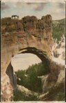 | "Arch of Victory" near Bryce Canyon | P0004 Wasatch Mountain Club Photograph Collection | P0004n14_01_062 |
| 4 |  | Hopkins in No Man's land, Jurassic period. Petrified wood on top of the ground | P0004 Wasatch Mountain Club Photograph Collection | P0004n14_01_063 |
| 5 |  | Bryce Canyon, Arch of Victory | P0004 Wasatch Mountain Club Photograph Collection | P0004n14_01_076 |
| 6 | 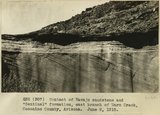 | Contact of Navajo sandstone and "Sentinal" formation, east branch of Warm Creek, Coconino County, Arizona.. June, 1915. | P0013 Herbert E. Gregory Photograph Collection | P0013n08_017_1341 |
| 7 | 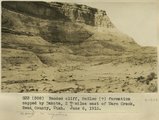 | Banded cliff, McElmo (?) formation capped by Dakota, 2+ miles east of Warm Creek, Kane County, Utah. June 8, 1915. | P0013 Herbert E. Gregory Photograph Collection | P0013n08_017_1342 |
| 8 | 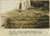 | Cliffs of McElmo formation 2+ miles east of Warm Creek, Kane County, Utah. June 8, 1915. | P0013 Herbert E. Gregory Photograph Collection | P0013n08_018_1343 |
| 9 | 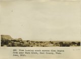 | View looking south across Glen Canyon from near Warm Creek, Kane County, Utah. June, 1915. | P0013 Herbert E. Gregory Photograph Collection | P0013n08_018_1344 |
| 10 | 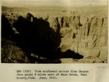 | View southeast across Glen Canyon from point 3 miles east of Warm Creek, Kane County, Utah. June, 1915. | P0013 Herbert E. Gregory Photograph Collection | P0013n08_019_1345 |
| 11 | 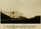 | Glen Canyon, 4+ miles above Crossing of the Fathers, Kane County, Utah. June, 1915. | P0013 Herbert E. Gregory Photograph Collection | P0013n08_019_1346 |
| 12 | 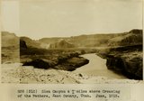 | Glen Canyon, 4+ miles above Crossing of the Fathers, Kane County, Utah. June, 1915. | P0013 Herbert E. Gregory Photograph Collection | P0013n08_020_1347 |
| 13 | 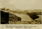 | Glen Canyon, 4+ miles above Crossing of the Fathers, Kane County, Utah. June, 1915. | P0013 Herbert E. Gregory Photograph Collection | P0013n08_020_1348 |
| 14 | 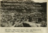 | Mesa Verde strata, west edge Kaiparowitz Plateau, Kane County, Utah. June, 1915. | P0013 Herbert E. Gregory Photograph Collection | P0013n08_021_1349 |
| 15 | 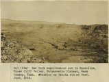 | Red rock amphitheater cut in Monocline, Upper Cliff Valley, Kaiparowitz Plateau, Kane County, Utah. Standing on Dakota rim at West. June, 1915. | P0013 Herbert E. Gregory Photograph Collection | P0013n08_021_1350 |
| 16 | 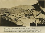 | Near head of "Cliff" Canyon, looking N. 70 degrees W. over Dakota toward Mancos and Mesa Verde (?), Kaiparowitz Plateau, Kane County, Utah. June 10, 1915. | P0013 Herbert E. Gregory Photograph Collection | P0013n08_022_1351 |
| 17 | 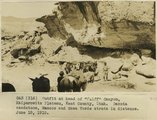 | Outfit at head of "Cliff" Canyon, Kaiparowitz Plateau, Kane County, Utah. Dakota sandstone, Mancos and Mesa Verde strata in distance. June 10, 1915. | P0013 Herbert E. Gregory Photograph Collection | P0013n08_022_1352 |
| 18 | 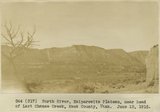 | North River, Kaiparowitz Plateau, near head of Last Chance Creek, Kane County, Utah. June 13, 1915. | P0013 Herbert E. Gregory Photograph Collection | P0013n08_023_1353 |
| 19 |  | Water Pocket Fold on trail to Smith (Baker) Ranch on Hall Creek. Landslide of Chinle material over LaPlata. Kane County, UT. June 1918 | P0013 Herbert E. Gregory Photograph Collection | P0013n08_071_1439 |
| 20 |  | Water Pocket Fold. Looking north 30 degrees west along Hall Creek Valley near where stream leaves McElmo to enter LaPlata. Kane County, UT. June 1918 | P0013 Herbert E. Gregory Photograph Collection | P0013n08_071_1440 |
| 21 | 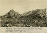 | Water Pocket Fold. LaPlata to the right, thin-bedded McElmo, heavy red McElmo bed at the left. Kane County, UT. June 1918 | P0013 Herbert E. Gregory Photograph Collection | P0013n08_072_1441 |
| 22 | 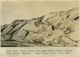 | Water Pocket Fold, near Baker Ranch, Hall Creek. LaPlata. Kane County, UT. June 1918 | P0013 Herbert E. Gregory Photograph Collection | P0013n08_072_1442 |
| 23 | 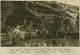 | Water Pocket Fold, Cave Springs, Hanson Creek. Cow Camp. Kane County, UT. June 1918 | P0013 Herbert E. Gregory Photograph Collection | P0013n08_073_1443 |
| 24 | 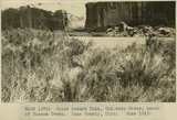 | Water Pocket Fold, Colorado River, mouth of Hanson Creek. Kane County, UT. June 1918 | P0013 Herbert E. Gregory Photograph Collection | P0013n08_073_1444 |
| 25 |  | Water Pocket Fold, Hanson Creek, near mouth. Kane County, UT. June 1918. LaPlata sandstone | P0013 Herbert E. Gregory Photograph Collection | P0013n08_074_1445 |