Home
Browse
Ask Us
Chat
Harmful Language Statement
Log in
Advanced Search
Year
1100
1101
1102
1103
1104
1105
1106
1107
1108
1109
1110
1111
1112
1113
1114
1115
1116
1117
1118
1119
1120
1121
1122
1123
1124
1125
1126
1127
1128
1129
1130
1131
1132
1133
1134
1135
1136
1137
1138
1139
1140
1141
1142
1143
1144
1145
1146
1147
1148
1149
1150
1151
1152
1153
1154
1155
1156
1157
1158
1159
1160
1161
1162
1163
1164
1165
1166
1167
1168
1169
1170
1171
1172
1173
1174
1175
1176
1177
1178
1179
1180
1181
1182
1183
1184
1185
1186
1187
1188
1189
1190
1191
1192
1193
1194
1195
1196
1197
1198
1199
1200
1201
1202
1203
1204
1205
1206
1207
1208
1209
1210
1211
1212
1213
1214
1215
1216
1217
1218
1219
1220
1221
1222
1223
1224
1225
1226
1227
1228
1229
1230
1231
1232
1233
1234
1235
1236
1237
1238
1239
1240
1241
1242
1243
1244
1245
1246
1247
1248
1249
1250
1251
1252
1253
1254
1255
1256
1257
1258
1259
1260
1261
1262
1263
1264
1265
1266
1267
1268
1269
1270
1271
1272
1273
1274
1275
1276
1277
1278
1279
1280
1281
1282
1283
1284
1285
1286
1287
1288
1289
1290
1291
1292
1293
1294
1295
1296
1297
1298
1299
1300
1301
1302
1303
1304
1305
1306
1307
1308
1309
1310
1311
1312
1313
1314
1315
1316
1317
1318
1319
1320
1321
1322
1323
1324
1325
1326
1327
1328
1329
1330
1331
1332
1333
1334
1335
1336
1337
1338
1339
1340
1341
1342
1343
1344
1345
1346
1347
1348
1349
1350
1351
1352
1353
1354
1355
1356
1357
1358
1359
1360
1361
1362
1363
1364
1365
1366
1367
1368
1369
1370
1371
1372
1373
1374
1375
1376
1377
1378
1379
1380
1381
1382
1383
1384
1385
1386
1387
1388
1389
1390
1391
1392
1393
1394
1395
1396
1397
1398
1399
1400
1401
1402
1403
1404
1405
1406
1407
1408
1409
1410
1411
1412
1413
1414
1415
1416
1417
1418
1419
1420
1421
1422
1423
1424
1425
1426
1427
1428
1429
1430
1431
1432
1433
1434
1435
1436
1437
1438
1439
1440
1441
1442
1443
1444
1445
1446
1447
1448
1449
1450
1451
1452
1453
1454
1455
1456
1457
1458
1459
1460
1461
1462
1463
1464
1465
1466
1467
1468
1469
1470
1471
1472
1473
1474
1475
1476
1477
1478
1479
1480
1481
1482
1483
1484
1485
1486
1487
1488
1489
1490
1491
1492
1493
1494
1495
1496
1497
1498
1499
1500
1501
1502
1503
1504
1505
1506
1507
1508
1509
1510
1511
1512
1513
1514
1515
1516
1517
1518
1519
1520
1521
1522
1523
1524
1525
1526
1527
1528
1529
1530
1531
1532
1533
1534
1535
1536
1537
1538
1539
1540
1541
1542
1543
1544
1545
1546
1547
1548
1549
1550
1551
1552
1553
1554
1555
1556
1557
1558
1559
1560
1561
1562
1563
1564
1565
1566
1567
1568
1569
1570
1571
1572
1573
1574
1575
1576
1577
1578
1579
1580
1581
1582
1583
1584
1585
1586
1587
1588
1589
1590
1591
1592
1593
1594
1595
1596
1597
1598
1599
1600
1601
1602
1603
1604
1605
1606
1607
1608
1609
1610
1611
1612
1613
1614
1615
1616
1617
1618
1619
1620
1621
1622
1623
1624
1625
1626
1627
1628
1629
1630
1631
1632
1633
1634
1635
1636
1637
1638
1639
1640
1641
1642
1643
1644
1645
1646
1647
1648
1649
1650
1651
1652
1653
1654
1655
1656
1657
1658
1659
1660
1661
1662
1663
1664
1665
1666
1667
1668
1669
1670
1671
1672
1673
1674
1675
1676
1677
1678
1679
1680
1681
1682
1683
1684
1685
1686
1687
1688
1689
1690
1691
1692
1693
1694
1695
1696
1697
1698
1699
1700
1701
1702
1703
1704
1705
1706
1707
1708
1709
1710
1711
1712
1713
1714
1715
1716
1717
1718
1719
1720
1721
1722
1723
1724
1725
1726
1727
1728
1729
1730
1731
1732
1733
1734
1735
1736
1737
1738
1739
1740
1741
1742
1743
1744
1745
1746
1747
1748
1749
1750
1751
1752
1753
1754
1755
1756
1757
1758
1759
1760
1761
1762
1763
1764
1765
1766
1767
1768
1769
1770
1771
1772
1773
1774
1775
1776
1777
1778
1779
1780
1781
1782
1783
1784
1785
1786
1787
1788
1789
1790
1791
1792
1793
1794
1795
1796
1797
1798
1799
1800
1801
1802
1803
1804
1805
1806
1807
1808
1809
1810
1811
1812
1813
1814
1815
1816
1817
1818
1819
1820
1821
1822
1823
1824
1825
1826
1827
1828
1829
1830
1831
1832
1833
1834
1835
1836
1837
1838
1839
1840
1841
1842
1843
1844
1845
1846
1847
1848
1849
1850
1851
1852
1853
1854
1855
1856
1857
1858
1859
1860
1861
1862
1863
1864
1865
1866
1867
1868
1869
1870
1871
1872
1873
1874
1875
1876
1877
1878
1879
1880
1881
1882
1883
1884
1885
1886
1887
1888
1889
1890
1891
1892
1893
1894
1895
1896
1897
1898
1899
1900
1901
1902
1903
1904
1905
1906
1907
1908
1909
1910
1911
1912
1913
1914
1915
1916
1917
1918
1919
1920
1921
1922
1923
1924
1925
1926
1927
1928
1929
1930
1931
1932
1933
1934
1935
1936
1937
1938
1939
1940
1941
1942
1943
1944
1945
1946
1947
1948
1949
1950
1951
1952
1953
1954
1955
1956
1957
1958
1959
1960
1961
1962
1963
1964
1965
1966
1967
1968
1969
1970
1971
1972
1973
1974
1975
1976
1977
1978
1979
1980
1981
1982
1983
1984
1985
1986
1987
1988
1989
1990
1991
1992
1993
1994
1995
1996
1997
1998
1999
2000
2001
2002
2003
2004
2005
2006
2007
2008
2009
2010
2011
2012
2013
2014
2015
2016
2017
2018
2019
2020
2021
2022
2023
2024
2025
TO
1100
1101
1102
1103
1104
1105
1106
1107
1108
1109
1110
1111
1112
1113
1114
1115
1116
1117
1118
1119
1120
1121
1122
1123
1124
1125
1126
1127
1128
1129
1130
1131
1132
1133
1134
1135
1136
1137
1138
1139
1140
1141
1142
1143
1144
1145
1146
1147
1148
1149
1150
1151
1152
1153
1154
1155
1156
1157
1158
1159
1160
1161
1162
1163
1164
1165
1166
1167
1168
1169
1170
1171
1172
1173
1174
1175
1176
1177
1178
1179
1180
1181
1182
1183
1184
1185
1186
1187
1188
1189
1190
1191
1192
1193
1194
1195
1196
1197
1198
1199
1200
1201
1202
1203
1204
1205
1206
1207
1208
1209
1210
1211
1212
1213
1214
1215
1216
1217
1218
1219
1220
1221
1222
1223
1224
1225
1226
1227
1228
1229
1230
1231
1232
1233
1234
1235
1236
1237
1238
1239
1240
1241
1242
1243
1244
1245
1246
1247
1248
1249
1250
1251
1252
1253
1254
1255
1256
1257
1258
1259
1260
1261
1262
1263
1264
1265
1266
1267
1268
1269
1270
1271
1272
1273
1274
1275
1276
1277
1278
1279
1280
1281
1282
1283
1284
1285
1286
1287
1288
1289
1290
1291
1292
1293
1294
1295
1296
1297
1298
1299
1300
1301
1302
1303
1304
1305
1306
1307
1308
1309
1310
1311
1312
1313
1314
1315
1316
1317
1318
1319
1320
1321
1322
1323
1324
1325
1326
1327
1328
1329
1330
1331
1332
1333
1334
1335
1336
1337
1338
1339
1340
1341
1342
1343
1344
1345
1346
1347
1348
1349
1350
1351
1352
1353
1354
1355
1356
1357
1358
1359
1360
1361
1362
1363
1364
1365
1366
1367
1368
1369
1370
1371
1372
1373
1374
1375
1376
1377
1378
1379
1380
1381
1382
1383
1384
1385
1386
1387
1388
1389
1390
1391
1392
1393
1394
1395
1396
1397
1398
1399
1400
1401
1402
1403
1404
1405
1406
1407
1408
1409
1410
1411
1412
1413
1414
1415
1416
1417
1418
1419
1420
1421
1422
1423
1424
1425
1426
1427
1428
1429
1430
1431
1432
1433
1434
1435
1436
1437
1438
1439
1440
1441
1442
1443
1444
1445
1446
1447
1448
1449
1450
1451
1452
1453
1454
1455
1456
1457
1458
1459
1460
1461
1462
1463
1464
1465
1466
1467
1468
1469
1470
1471
1472
1473
1474
1475
1476
1477
1478
1479
1480
1481
1482
1483
1484
1485
1486
1487
1488
1489
1490
1491
1492
1493
1494
1495
1496
1497
1498
1499
1500
1501
1502
1503
1504
1505
1506
1507
1508
1509
1510
1511
1512
1513
1514
1515
1516
1517
1518
1519
1520
1521
1522
1523
1524
1525
1526
1527
1528
1529
1530
1531
1532
1533
1534
1535
1536
1537
1538
1539
1540
1541
1542
1543
1544
1545
1546
1547
1548
1549
1550
1551
1552
1553
1554
1555
1556
1557
1558
1559
1560
1561
1562
1563
1564
1565
1566
1567
1568
1569
1570
1571
1572
1573
1574
1575
1576
1577
1578
1579
1580
1581
1582
1583
1584
1585
1586
1587
1588
1589
1590
1591
1592
1593
1594
1595
1596
1597
1598
1599
1600
1601
1602
1603
1604
1605
1606
1607
1608
1609
1610
1611
1612
1613
1614
1615
1616
1617
1618
1619
1620
1621
1622
1623
1624
1625
1626
1627
1628
1629
1630
1631
1632
1633
1634
1635
1636
1637
1638
1639
1640
1641
1642
1643
1644
1645
1646
1647
1648
1649
1650
1651
1652
1653
1654
1655
1656
1657
1658
1659
1660
1661
1662
1663
1664
1665
1666
1667
1668
1669
1670
1671
1672
1673
1674
1675
1676
1677
1678
1679
1680
1681
1682
1683
1684
1685
1686
1687
1688
1689
1690
1691
1692
1693
1694
1695
1696
1697
1698
1699
1700
1701
1702
1703
1704
1705
1706
1707
1708
1709
1710
1711
1712
1713
1714
1715
1716
1717
1718
1719
1720
1721
1722
1723
1724
1725
1726
1727
1728
1729
1730
1731
1732
1733
1734
1735
1736
1737
1738
1739
1740
1741
1742
1743
1744
1745
1746
1747
1748
1749
1750
1751
1752
1753
1754
1755
1756
1757
1758
1759
1760
1761
1762
1763
1764
1765
1766
1767
1768
1769
1770
1771
1772
1773
1774
1775
1776
1777
1778
1779
1780
1781
1782
1783
1784
1785
1786
1787
1788
1789
1790
1791
1792
1793
1794
1795
1796
1797
1798
1799
1800
1801
1802
1803
1804
1805
1806
1807
1808
1809
1810
1811
1812
1813
1814
1815
1816
1817
1818
1819
1820
1821
1822
1823
1824
1825
1826
1827
1828
1829
1830
1831
1832
1833
1834
1835
1836
1837
1838
1839
1840
1841
1842
1843
1844
1845
1846
1847
1848
1849
1850
1851
1852
1853
1854
1855
1856
1857
1858
1859
1860
1861
1862
1863
1864
1865
1866
1867
1868
1869
1870
1871
1872
1873
1874
1875
1876
1877
1878
1879
1880
1881
1882
1883
1884
1885
1886
1887
1888
1889
1890
1891
1892
1893
1894
1895
1896
1897
1898
1899
1900
1901
1902
1903
1904
1905
1906
1907
1908
1909
1910
1911
1912
1913
1914
1915
1916
1917
1918
1919
1920
1921
1922
1923
1924
1925
1926
1927
1928
1929
1930
1931
1932
1933
1934
1935
1936
1937
1938
1939
1940
1941
1942
1943
1944
1945
1946
1947
1948
1949
1950
1951
1952
1953
1954
1955
1956
1957
1958
1959
1960
1961
1962
1963
1964
1965
1966
1967
1968
1969
1970
1971
1972
1973
1974
1975
1976
1977
1978
1979
1980
1981
1982
1983
1984
1985
1986
1987
1988
1989
1990
1991
1992
1993
1994
1995
1996
1997
1998
1999
2000
2001
2002
2003
2004
2005
2006
2007
2008
2009
2010
2011
2012
2013
2014
2015
2016
2017
2018
2019
2020
2021
2022
2023
2024
2025
Type
Image/StillImage
332,306
Image
329,527
Text
43,102
Image/MovingImage
22
Sound
18
InteractiveResource
2
More
Format
image/jpeg
802,160
Collection
Afton Watkins Gardner Collection
80
Al W. Morton Collection, 1930s-1950s
780
American Westward Migration
41
Antelope Island Buffalo Hunt Photogra...
8
Anthropology Artifact Images
21,600
Anthropology Ethnographic Collections
10,698
Arabic Papyrus, Parchment, and Paper
2,145
Art and Art History Department PR Pho...
27,458
Art and Art History Video
1
Artifact Collection
5
Ashton, Evans, and Brazier Architectu...
11
Athletics
762
Beckwith Photograph Collection
3,911
Botany Vascular Plants
3,492
Brain Institute
207
C. R. Savage Company Portrait Collection
13,417
CAP History
1,209
Cartoons and Caricatures of Men in Utah
154
Charles Raymond Varley Slides, 1868-1986
184
Chicana/o Scholarship Archive
1
City Engineers
1,000
Civilian Conservation Corps
1,450
Classified Photographs
30,056
Clifton Bray Film Negatives
3,100
College of Architecture + Planning
5,195
College of Law Publications
5,829
College of Nursing
34
College of Pharmacy
154
Connell O'Donovan LGBT Utah History C...
1,499
Cycling Utah
1
Discovery and Innovation at Universit...
100
Division of Games Archive
81
Downwinders of Utah Archive
1
Eccles Health Sciences Library History
109
Electronic University Archive
114
Ellis Reynolds Shipp Papers
4
Entomology Specimen Photos
19,709
Extractions from the Land: Mining and...
646
Fayez A. Sayegh Collection
1
Federal Resource Corporation Papers
147
France Davis Utah Black Archive
40
Fredrick and Nellie Hill Salt Lake Ci...
16
GApp Lab Wrap Kits
185
General Refractories Company Collection
260
George A. Smith Papers
5
George Cannon Young Architecture
740
George M. Ottinger Photograph Collection
2,501
Glen Canyon
337
Golden Spike Sesquicentennial
51
Governor's Olympic Collection
4,906
Great Basin Association Photographs
71
Great Basin Museum
47
Great Basin National Heritage Area Or...
3
Green River Launch Complex
70
Green River Public Library - Pearl Bi...
4
Harvard Peabody Site Reports
6,190
Health Education Assets Library (HEAL)
4,089
Hidden Water - Salt Lake County Water...
300
History of the Health Sciences at the...
266
Hotel Utah
4,366
Invertebrate Paleontology Collection ...
1,538
John Peter Simonson Photograph Collec...
57
John W. Sugden Papers
161
John Wesley Powell Collection
6
Juanita Brooks Photograph Collection,...
625
KUED Topaz Residents Collection
219
Kennecott Miner Records
39,714
Kent Day Family Collection
11
Larson Studio Negative Collection
22,894
Lehi Historical Society
13
Lennox and Catherine Tierney Photogra...
11,870
Let Freedom Read Dress
28
Life Story Library collection
49
Lloyd and Kiyomi Takehara Ryujin Phot...
2
Manuscripts
73
Markers and Monuments
2,160
Marriner S. Eccles Papers
1
Marriott Digital Publishing Archive
4
Marriott Library Items
3
Marriott Library Posters
264
Media Resources
1
Montmorency, Hayes and Talbot archite...
5
More Than A Flag: Utah State Flag Red...
7,024
Movies Made in Utah Photograph Collec...
48
Murray Museum
4,205
NHMU Communications Test Collection
5
NOVEL
13
NOVEL - AAO-NANOS Clinical Collection
361
NOVEL - Daniel Gold Collection
60
NOVEL - David G. Cogan Collection
101
NOVEL - Emory Eye Center
2
NOVEL - Frank B. Walsh Collection
199
NOVEL - Irene E. Loewenfeld Pupil Col...
68
NOVEL - J. Lawton Smith Lecture Colle...
21
NOVEL - Jonathan D. Trobe Collection
472
NOVEL - Moran Eye Center
66
NOVEL - NANOS Historical Collection
8
NOVEL - Neil R. Miller Collection
1,065
NOVEL - William F. Hoyt Collection
856
NTC Archives
25
Neil L. Astle Papers - Reading Room A...
19
Office of Undergraduate Research Library
2
Olympic Legacy
2,479
Pantages Theatre - Salt Lake City
721
Park City Historical Society
14
Park City Historical Society & Museum
13,058
Peoples of Utah
868
Peoples of Utah Revisited
810
Philo T. Farnsworth Television Tubes
101
Photo Archives
84,764
Project Art Heals Utah
77
Protocol Registry of Evidence Reviews...
1
Quinney - Iraq Project
208
Rare Books Collection
259
Ray King Collection
719
Regional History Center
18,176
Research Reproducibility
25
Restricted Indigenous Collections
124
Richard K. A. Kletting Architectural ...
104
Richard Kern's Far West Sketches: A V...
396
Right Whale Collection
83,849
Right Whale Contacts Collection
4,993
Right Whale Notes Collection
1,836
Rural Utah Curated Collection
143
Salt Lake City Religious Architecture...
396
Salt Lake Climbers Alliance
74
Salt Lake Tribune Negative Collection
171,664
Sanborn Fire Insurance Maps
1,966
Sanborn Fire Insurance Maps, Division...
3,291
School of Medicine
636
Schools of the Salt Lake Valley
100
Shipler Commercial Photographers
13,151
Ski and Snow Sports Photo Archives
28,182
Summit County History Department
192
Susan Barbara Tallmon Sargent
3
Sustainability U
2
Taylor A. Woolley Papers
464
Taylor Woolley Photograph Collection
58
Theses & Dissertations
10
Thorne Photographs
23,162
Topaz Museum
216
UAIDA Main Collection
3,384
UScholar Works
152
Uintah County Regional History Center...
329
University Archival Photographs (P0305)
4,790
University of Utah Health Hospitals &...
2
Utah Artists Project
2,942
Utah Artists Project - Ephemera
33
Utah COVID-19
1,004
Utah Historical Society Railroad Map ...
1,248
Utah Museum of Fine Arts
173
Utah Postcards Collection, 1880s-1924
3
Utah Power and Light Photographs, 194...
96
Utah Religious Architecture Photographs
1,602
Utah River Running Photo Archives
17,608
Utah State Board Of Regents
1
Utah State Legislators Photographs, 1...
1,388
Utah's Urban Pioneer Folk Music Reviv...
1
Vernal Express Photographs
17,877
Vertebrate Zoology Field Notes
2
Vertebrate Zoology Voucher Images
16,685
We Remember, We Celebrate, We Believe...
2
Western Soundscape
3
Western Soundscape Spectrograms
224
Western Waters Audio-Video
3
Western Waters NEH
4
Western Waters Photographs
1
Westminster University COVID-19 Digit...
3
Westminster University Photographs
1,065
William Edward Hook Glass Negatives
84
More
Filters:
Format:
"image/jpeg"
2326
-
2350
of
802,160
<
89
90
91
92
93
94
95
96
97
98
>
Gallery view
Number of results to display per page
10
25
50
100
200
Sort by Relevance
Sort by Title A-Z
Sort by Title Z-A
Sort by Date Ascending
Sort by Date Descending
Sort by Last Modified Ascending
Sort by Last Modified Descending
Title
Date
Type
Setname
2326
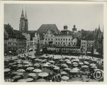
(C) Castle Yard, Nuremberg, Germany (before Allied bombings of 1944-1945)
1935; 1936; 1937; 1938; 1939; 1940; 1941; 1942; 1943; 1944
Image
uum_map
2327
(D) Market Place "Old City", Nuremberg, Germany (after Allied bombings of 1944-1945)
1946; 1947; 1948; 1949
Image
uum_map
2328
(D) Market Place "Old City", Nuremberg, Germany (before Allied bombings of 1944-1945)
1935; 1936; 1937; 1938; 1939; 1940; 1941; 1942; 1943; 1944
Image
uum_map
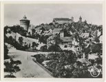
2329
(E) View from Haller Gate, Nuremberg, Germany (after Allied bombings of 1944-1945)
1946; 1947; 1948; 1949
Image
uum_map
2330
(E) View from Haller Gate, Nuremberg, Germany (before Allied bombings of 1944-1945)
1935; 1936; 1937; 1938; 1939; 1940; 1941; 1942; 1943; 1944
Image
uum_map
2331
(East elevation, Ensign School renovation, draft)
1944
Image/StillImage
uum_gcya
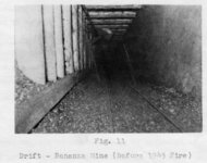
2332
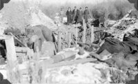
(Fig. 11) "Drift-Bonanza Mine (Before 1945 fire)."
1940; 1941; 1942; 1943; 1944; 1945
Image/StillImage
uum_map
2333
(Fig. 11) "The Bandana Mine on the Cowboy Vein."
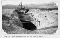
1934
Image/StillImage
uum_map
2334
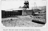
(Fig. 12) "The melt plant of the Pariette Mining Company."
1934
Image/StillImage
uum_map
2335
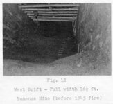
(Fig. 12) "West drift - Full width 16½ ft. [at] Bonanza Mine (before 1945 fire)."
1940; 1941; 1942; 1943; 1944; 1945
Image/StillImage
uum_map
2336
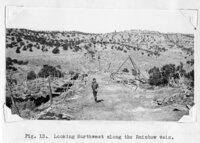
(Fig. 13) "Looking northwest along the Rainbow vein."
1934
Image/StillImage
uum_map
2337
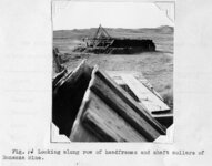
(Fig. 14) "Looking along row of headframes and shaft collars of Bonanza Mine."
1934
Image/StillImage
uum_map
2338
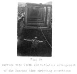
(Fig. 14) "Surface vein width and tail-rope arrangement of the Bonanza Mine stripping operations".
1949
Image/StillImage
uum_map
2339
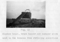
(Fig. 15) "Slusher house, truck hopper and scraper slide used in the Bonanza Mine stripping operations."
1949
Image/StillImage
uum_map
2340
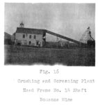
(Fig. 16) "Crushing and Screening Plant, Head Frame No. 14 Shaft, Bonanza Mine."
1949
Image/StillImage
uum_map
2341
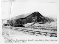
(Fig. 16.) "Ore from American Asphalt Association Mines awaiting shipment at Dragon, Utah."
1934
Image/StillImage
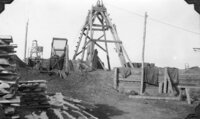
uum_map
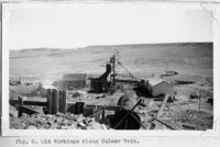
2342
(Fig. 2) "Old workings along Culmer vein"
1934
Image/StillImage
uum_map
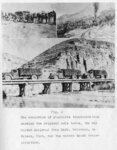
2343
(Fig. 2) "The evolution of gilsonite transportation showing the original mule teams, the old Uintah Railroad from Mack, Colorado, to Watson, Utah, and the modern truck transportation."
1949
Image/StillImage
uum_map
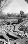
2344
(Fig. 24a) "A prospect pit on the Stacey reed Lease sunk in search of the Fort Duchesne vein, hidden beneath the mantle of boulders and river gravel from the Uinta River. The man inspecting the pit is Harry Pearson, one of the stockholders of the Western Gilsonite and Elaterite Company."
1949
Image/StillImage
uum_map
2345
(Fig. 24b) "Wayne Thomas, mining engineer in charge, and a party of visitors inspecting preparations for pouring the concrete for the retaining wall to hold out surface water and sand until a reinforced [sic] concrete collar could be constructed on the bed-rock [sic] about 15 feet below the surface. Note several sacks of gilsonite salvaged from the vein in order to make room for the shaft collar."
1940
Image/StillImage
uum_map
2346
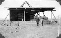
(Fig. 25a) "West view of Arrowchis Shaft showing head frame, loading platform (walled in on windward sides), simple built-in screening plant a rack of sacked gilsonite, and two stockholders, R. L. Hedrick (left), and Harry Pearson. The upper deck served as a protective shed for the loading platform and as a floor to hold each digger's sacks, as they were hoisted from the stopes, until they were sorted, graded, and screened, after which they were racked on the loading platform below for shipment."
1940
Image/StillImage
uum_map
2347
(Fig. 25b) "North view of Arrowchis Shaft of the Western Gilsonite and Elaterite Company, showing four-pole construction of simple head frame. Note mine timber and bath-house (to left and beyond shed). Clothes-line and small building to right of shed are just west of Superintendent's house hidden by the head frame and loading shed."
1940
Image/StillImage
uum_map
2348
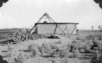
(Fig. 26a) "View from edge of River Terrace looking southeast along the strike fo the Fort Duchesne Vein toward the Arrowchis Lease from near the point of original discovery of this vein, just northwest of the commercial portion of the vein. Over the top of the house in the center can be seen the dim outline of a string of headframes (including those in "B" below) over the closely-spaced shafts of the Raven Mining Company."
1940
Image/StillImage
uum_map
2349
(Fig. 26b) "Headframes over tow chief shafts on the Raven Mining Company's portion of the Fort Duchesne vein. These shafts were deepened and somewhat modernized to service the lower levels. The shafts between, and on either side were then abandoned. Note hand screening equipment, power line, and slabs for lagging the ming."
1940
Image/StillImage
uum_map
2350
(Fig. 28) "Two views of the head-frame of the Stacey Reed shaft, taken from near the south boundary of the Arrowchis Lease of the Western Gilsonite and Elaterite Company, and from a point approximately where it is proposed to sink the new two-compartment deep shaft for pemanent commercial production. The Stacey Reed shaft here shown will serve as auxiliary manway and airway for the new shaft of the Western Gilsonite and Elaterite Company by permitting this use of their shaft, and will bear their share of the hoisting and drifting necessary to make the connection. As explained in the text, the overhead thus saved will be of vital importance to all concerned. Note the rick of sacked gilsonite near the shaft. The discovery of commercial gilsonite at this point on the vein beyond the boundary line of the Arrowchis Lease proved beyond question the ‘ore' body throughout the full length of the lease."
1940
Image/StillImage
uum_map
2326
-
2350
of
802,160
<
89
90
91
92
93
94
95
96
97
98
>