| Title | Date | Type | Setname | ||
|---|---|---|---|---|---|
| 901 |
 |
Aerial view of a Southern Utah red rock landscape with buildings and parked vehicles and boats | 1962; 1963; 1964; 1965; 1966; 1967; 1968 | Image/StillImage | uum_map |
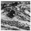
| 902 |
 |
Aerial view of a Southern Utah red rock landscape with multiple mobile homes | 1962; 1963; 1964; 1965; 1966; 1967; 1968 | Image/StillImage | uum_map |
| 903 |
 |
Aerial view of a Southern Utah red rock landscape with parking area | 1962; 1963; 1964; 1965; 1966; 1967; 1968 | Image/StillImage | uum_map |
| 904 |
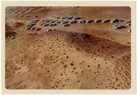 |
Aerial view of a Southern Utah red rock landscape with parking area and cars | 1962; 1963; 1964; 1965; 1966; 1967; 1968 | Image/StillImage | uum_map |
| 905 |
 |
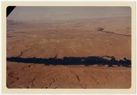
Aerial view of a Southern Utah red rock landscape with river [1] | 1962; 1963; 1964; 1965; 1966; 1967; 1968 | Image/StillImage | uum_map |
| 906 |
 |
Aerial view of a Southern Utah red rock landscape with river [2] | 1962; 1963; 1964; 1965; 1966; 1967; 1968 | Image/StillImage | uum_map |
| 907 |
 |
Aerial view of a Southern Utah red rock landscape with river [3] | 1962; 1963; 1964; 1965; 1966; 1967; 1968 | Image/StillImage | uum_map |
| 908 |
 |
Aerial view of a Southern Utah red rock landscape with several buildings and mobile homes | 1962; 1963; 1964; 1965; 1966; 1967; 1968 | Image/StillImage | uum_map |
| 909 |
 |
Aerial view of a Southern Utah red rock landscape with structures | 1962; 1963; 1964; 1965; 1966; 1967; 1968 | Image/StillImage | uum_map |
| 910 |
 |
Aerial view of a Southern Utah red rock landscape with water | 1962; 1963; 1964; 1965; 1966; 1967; 1968 | Image/StillImage | uum_map |
| 911 |
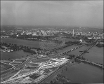 |
Aerial view of a Washington D.C. Marriott Hotel. | 1960; 1961; 1962; 1963; 1964; 1965; 1966; 1967; 1968; 1969 | uum_map | |
| 912 |
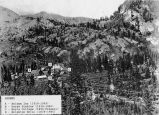 |
Aerial view of Brighton with cabins and lodges labeled and dated. | 1960; 1961; 1962; 1963; 1964; 1965; 1966; 1967; 1968; 1969 | Image | uum_map_usa |
| 913 |
 |
Aerial view of Capitol Hill, Salt Lake City | 1964; 1965; 1966; 1967; 1968; 1969; 1970; 1971; 1972; 1973; 1974; 1975; 1976; 1977; 1978; 1979; 1980; 1981; 1982; 1983; 1984; 1985 | uum_map | |
| 914 |
 |
Aerial view of cornice control fences | 1940; 1941; 1942; 1943; 1944; 1945; 1946; 1947; 1948; 1949; 1950; 1951; 1952; 1953; 1954; 1955; 1956; 1957; 1958; 1959; 1960; 1961; 1962; 1963; 1964; 1965; 1966; 1967; 1968; 1969 | Image | uum_map_usa |
| 915 |
 |
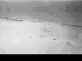
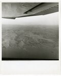
Aerial view of desert-like landscape [1] | 1964; 1965; 1966; 1967; 1968; 1969; 1970; 1971; 1972; 1973; 1974; 1975 | Image/StillImage | uum_map |
| 916 |
 |
Aerial view of desert-like landscape [2] | 1964; 1965; 1966; 1967; 1968; 1969; 1970; 1971; 1972; 1973; 1974; 1975 | Image/StillImage | uum_map |
| 917 |
 |
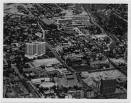
Aerial view of entire University of Utah campus | 1950; 1951; 1952; 1953; 1954; 1955; 1956; 1957; 1958; 1959; 1960; 1961; 1962; 1963; 1964; 1965; 1966; 1967; 1968; 1969; 1970; 1971; 1972; 1973 | Image/StillImage | uum_map |
| 918 |
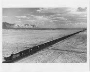 |
Aerial view of freight train hauling coal. | 1960; 1961; 1962; 1963; 1964; 1965; 1966; 1967; 1968; 1969; 1970; 1971; 1972; 1973; 1974; 1975; 1976 | Image | uum_map |
| 919 |
 |
Aerial view of Grand Canyon | 1950; 1951; 1952; 1953; 1954; 1955; 1956; 1957; 1958; 1959; 1960; 1961; 1962; 1963; 1964; 1965; 1966; 1967; 1968; 1969; 1970; 1971; 1972; 1973; 1974; 1975; 1976; 1977; 1978; 1979; 1980 | Image | uum_map_rr |
| 920 |
 |
Aerial view of Kelly Canyon lodge | 1960; 1961; 1962; 1963; 1964; 1965; 1966; 1967; 1968; 1969; 1970 | uum_map_usa | |
| 921 |
 |
Aerial view of Kelly Canyon lodge and car park | 1960; 1961; 1962; 1963; 1964; 1965; 1966; 1967; 1968; 1969; 1970 | uum_map_usa | |
| 922 |
 |
Aerial view of Kelly Canyon mountain | 1960; 1961; 1962; 1963; 1964; 1965; 1966; 1967; 1968; 1969; 1970 | uum_map_usa | |
| 923 |
 |
Aerial view of Lake Powell | 1964; 1965; 1966; 1967; 1968; 1969; 1970; 1971; 1972; 1973; 1974; 1975 | Image/StillImage | uum_map |
| 924 |
 |
Aerial view of landscape with two recreational vehicles | 1964; 1965; 1966; 1967; 1968; 1969; 1970; 1971; 1972; 1973; 1974; 1975 | Image/StillImage | uum_map |
| 925 |
 |
aerial view of Lower Park City | 1964 | Image | pc_hsm |