Home
Browse
Ask Us
Chat
Harmful Language Statement
Log in
Advanced Search
Year
1920
1921
1922
1923
1924
1925
1926
1927
1928
1929
1930
1931
1932
1933
1934
1935
1936
1937
1938
1939
1940
1941
1942
1943
1944
1945
1946
1947
1948
1949
1950
1951
1952
1953
1954
1955
1956
1957
1958
1959
1960
1961
1962
1963
1964
1965
1966
1967
1968
1969
1970
1971
1972
1973
1974
1975
1976
1977
1978
1979
1980
1981
1982
1983
1984
1985
1986
1987
1988
1989
1990
1991
1992
1993
1994
1995
1996
1997
1998
1999
2000
2001
2002
TO
1920
1921
1922
1923
1924
1925
1926
1927
1928
1929
1930
1931
1932
1933
1934
1935
1936
1937
1938
1939
1940
1941
1942
1943
1944
1945
1946
1947
1948
1949
1950
1951
1952
1953
1954
1955
1956
1957
1958
1959
1960
1961
1962
1963
1964
1965
1966
1967
1968
1969
1970
1971
1972
1973
1974
1975
1976
1977
1978
1979
1980
1981
1982
1983
1984
1985
1986
1987
1988
1989
1990
1991
1992
1993
1994
1995
1996
1997
1998
1999
2000
2001
2002
Type
Image
738
Image/StillImage
107
Text
1
Format
image/jpeg
2,440
Collection
Peoples of Utah Revisited
30
Photo Archives
984
Ski and Snow Sports Archives
705
University Archival Photographs (P0305)
19
Utah River Running Photo Archives
702
Filters:
Genre:
"color slides"
751
-
775
of
2,440
<
26
27
28
29
30
31
32
33
34
35
>
Gallery view
Number of results to display per page
10
25
50
100
200
Sort by Relevance
Sort by Title A-Z
Sort by Title Z-A
Sort by Date Ascending
Sort by Date Descending
Sort by Last Modified Ascending
Sort by Last Modified Descending
Title
Date
Type
Setname
751
Evanston stream revetments [12]
2002-04-29
uum_map
752
Evanston stream revetments [13]
2002-04-29
uum_map
753
Evanston stream revetments [14]
2002-04-29
uum_map
754
Evanston stream revetments [15]
2002-04-29
uum_map
755
Evanston stream revetments [16]
2002-04-29
uum_map
756
Evanston stream revetments [17]
2002-04-29
uum_map
757
Evanston stream revetments [18]
2002-04-29
uum_map
758
Evanston stream revetments [19]
2002-04-29
uum_map
759
Excavation and trench cave-ins occur all too frequently along Utah's Wasatch Front. Each year sees its fatalities from this cause.
Image
uum_map
760
Excavation for a covered distribution reservoir is pointed out in the photo. Note that drainages have been truncated. Reservoir is in an urban area with considerable development downslope. Geologic materials comprising the site are unstable. Geologic faults are mapped bounding the site, and springs issue from excavation walls and floor.
Image
uum_map
761
Expedition flag in Lodore.
1955
uum_map_rr
762
Expensive new house being constructed on banks of perennial stream which is subject to flood each spring and throughout the summer. Should not a form of flood plain zoning be in effect?
Image
uum_map
763
Exploring
1955
uum_map_rr
764
Exposure of a branch of the Wasatch Fault in a sand and gravel pit along the mountain front. Amount of displacement is indeterminable from the stratigraphy exposed. Note that the fault is planar and stands out with relative resistance to the elements despite lack of cementation of the sand and gravel.
Image
uum_map
765
Failure of front yard before completion of home construction in mountain subdivision.
Image
uum_map
766
Failure of ground bordering on a covered distribution reservoir. Hammer provides scale on displacement scarp.
Image
uum_map
767
Failure of undisturbed hillside bordering on Bear Lake (to left just off edge of road and photo). This hillside is particularly valuable as view property for resort development, yet is failing without any terrain modification by man.
Image
uum_map
768
Fall time view of Park City from Park West ski resort.
1960; 1961; 1962; 1963; 1964; 1965; 1966; 1967; 1968; 1969
Image
uum_map_usa
769
Fault trace of the active Wasatch Fault across a glacial moraine at the mouth of Little Cottonwood Canyon in Salt Lake County. Note that the fault scarplet is virtually unvegetated, indicative of its recency.
Image
uum_map
770
Fault trace revealed in the foundation excavation for the building depicted in the preceding photograph (p1274n092).
Image
uum_map
771
Fern Glen
1956
uum_map_rr
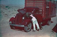
772
First boat on river, April 4, 1948
1948-04-04
Image/StillImage
uum_map
773
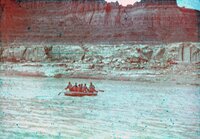
First stop between Green River and Hanksville, April 3, 1948
1948-04-03
Image/StillImage
uum_map
774
Flaming Gorge.
1955
uum_map_rr
775
Flaming Gorge.
1955
uum_map_rr
751
-
775
of
2,440
<
26
27
28
29
30
31
32
33
34
35
>