|
|
Title | Date | Type | Setname |
| 1 |
 |
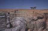
Aerial of north side of canyon, paved view area. | 1962-08 | Image | uum_map_rr |
| 2 |
 |
Aerial tramway, batch plant | 1962-08 | Image | uum_map_rr |
| 3 |
 |
American Gilsonite County Fair Display | 1962-08 | Image | ucl_tp |
| 4 |
 |
Around the World, Burma pagoda | 1962-08 | Image | uum_map |
| 5 |
 |
Bank of Vernal | 1962-08 | Image | ucl_tp |
| 6 |
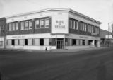 |
Bank of Vernal | 1962-08 | Image | ucl_tp |
| 7 |
 |
Dode Rolfe at Telephone Office | 1962-08 | Image | ucl_tp |
| 8 |
 |
Edith Pitt and Dode Rolfe | 1962-08 | Image | ucl_tp |
| 9 |
 |
Gantry crane, south side. | 1962-08 | Image | uum_map_rr |
| 10 |
 |
Gantry crane, south side. | 1962-08 | Image | uum_map_rr |
| 11 |
 |
Gantry crane, south side. | 1962-08 | Image | uum_map_rr |
| 12 |
 |
Gantry crane, south side. | 1962-08 | Image | uum_map_rr |
| 13 |
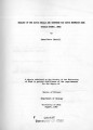 |
Geology of the Davis Knolls and northern Big Davis Mountain area, Tooele County, Utah | 1962-08 | Text; Image | ir_etd |
| 14 |
 |
Geology of the Davis Knolls and northern Big Davis Mountain area, Tooele County, Utah (Google Earth map overlay KMZ file) | 1962-08 | Image | ir_etd |
| 15 |
 |
Geology of the Davis Knolls and northern Big Davis Mountain area, Tooele County, Utah: Georeferenced map files | 1962-08 | Image | ir_etd |
| 16 |
 |
L.D.S. Church-Administration Square p.2 | 1962-06; 1962-07; 1962-08 | Image | dha_cp |
| 17 |
 |
Maids of Maeser | 1962-08 | Image | ucl_tp |
| 18 |
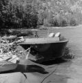 |
Middle Fork, Salmon River -- "Don Smith rig"; powerboat tied to shore | 1962-08 | Image | uum_map_rr |
| 19 |
 |
Middle Fork, Salmon River -- interior of powerboat | 1962-08 | Image | uum_map_rr |
| 20 |
 |
Middle Fork, Salmon River -- mountain scenery | 1962-08 | Image | uum_map_rr |
| 21 |
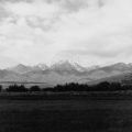 |
Middle Fork, Salmon River -- mountain scenery | 1962-08 | Image | uum_map_rr |
| 22 |
 |
Middle Fork, Salmon River -- outboard motors on boat | 1962-08 | Image | uum_map_rr |
| 23 |
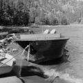 |
Middle Fork, Salmon River -- powerboat tied to shore | 1962-08 | Image | uum_map_rr |
| 24 |
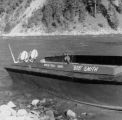 |
Middle Fork, Salmon River -- powerboat tied to shore; " 'Bob' Smith, North Fork, Idaho" painted on side of boat | 1962-08 | Image | uum_map_rr |
| 25 |
 |
Mouth of north diversion tunnel | 1962-08 | Image | uum_map_rr |