Home
Browse
Ask Us
Chat
Harmful Language Statement
Log in
Art and Art History
Advanced Search
About
Curriculum-based images for use in teaching, research, and learning.
Subject
Maps
169
Asian Art
27
Brazil
13
Buddhism
9
Buddhist Art
8
Architecture
6
Latin America
5
Ruins
5
Colonial Latin America
4
Japanese Art
3
Latin American Art
3
Asia
2
Boston Massacre
2
French History
2
French Revolution
2
History
2
Islamic Art
2
Napoleon Bonaparte
2
Napoleonic Wars
2
South America
2
Art Academy
1
Aztec Empire
1
Ceramics
1
China
1
Contemporary Asian Art
1
Dutch Brazil
1
Hindu Art
1
Hinduism
1
India
1
Korean Art
1
Middle East
1
Religious Art
1
Religious Buildings
1
World History
1
More
Style Period
Medieval Art
12
18th Century Art
8
20th Century Art
7
Antiquity
6
Byzantine Art (Byzantium)
5
Islamic Art: Fatimid Period
4
16th Century Art
3
17th Century Art
3
Ancient Rome: Empire
3
15th Century Renaissance: Italy
2
15th Century, 16th Century Renaissance: Italy
2
16th Century Renaissance: Northern Europe
2
17th Century Art: Northern Europe
2
19th Century Art
2
20th Century Graphic Design
2
Ancient Rome
2
China: Qin Dynasty
2
China: Shang Dynasty
2
Indonesia: Sailendra Dynasty, Srivijayan Empire
2
Late Antique and Early Christian
2
14th Century Art
1
15th Century Renaissance
1
16th Century Maps
1
16th Century Renaissance
1
16th Century Renaissance: Northern Europe
1
16th Century Renaissance: Southern Europe
1
16th Century Renaissance: Southern Europe
1
17th Century Art: Northern Europe
1
17th Century Renaissance
1
18th Century American Art
1
21st Century Art
1
Ancient Greece: Classical
1
Ancient Rome: Empire
1
Australia
1
Bronze Age
1
Bronze Age / Iron Age
1
Carthage: Roman Era
1
China: Eastern Zhou Dynasty
1
China: Han Dynasty
1
China: Xia Dynasty
1
Colonial Latin American Art
1
Contemporary Art
1
Indian Art and Architecture
1
Islamic Art: Nasrid Dynasty
1
Islamic Art: Umayyad
1
Islamic Art: Umayyad Period
1
Japan: Asuka Period
1
Late Antique and Early Christian Art
1
Mesopotamia
1
Modern Art
1
Native American Art
1
Neolithic
1
Paleolithic / Neolithic Art
1
Warring States
1
More
Filters:
Collection:
"uu_aah_art"
Subject:
"Maps"
1
-
25
of
169
<
1
2
3
4
5
6
7
>
Gallery view
Number of results to display per page
10
25
50
100
200
Sort by Relevance
Sort by Title A-Z
Sort by Title Z-A
Sort by Date Ascending
Sort by Date Descending
Sort by Last Modified Ascending
Sort by Last Modified Descending
Sort by Module Order
Title
Creator
Creation Date
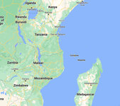
1
Map: Makonde people were in contemporary Kenya, Tanzania, and Mozambique
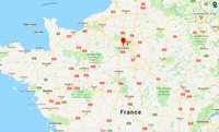
2
Map: Paris and Versailles, France
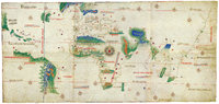
3
Cantino Planisphere
unknown
1502 CE
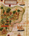
4
Terra Brasilis (detail)
Lopo Homem; Pedro Reinel; Jorge Reinel
1515 - 1519 CE
5
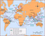
Map: Dutch Trade Routes
6
New World Map
Diogo Homem
1568 CE
7
Map: Nigeria in West Africa
8
Map: The Roman Empire
9
Map: Locations of 1937 Paris World's Fair, the Berlin Olympics, Nuremberg Rallies, and Great German and Degenerate Art Exhibits
10
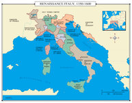
Map: Renaissance Italy 1350 - 1600 CE
11
Map: Europe, 1648 CE
12
Map: Aztec Empire in 1518 CE
1518 CE
13
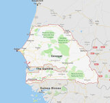
Map: Senegal
14
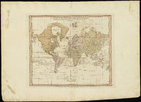
A chart of the world upon Mercator's projection : describing the tracks of Capt. Cook in the year 1768, 69, 70, 71, and in 1772, 73, 74, 75, with the new discoveries
William Faden
1775 CE
15
A new plan of ye great town of Boston in New England in America, with the many additionall [sic] buildings, & new streets, to the year, 1769
William Price; John Bonner
1769 CE
16
Map: The Empire on the Eve of the French Revolution, 1789
17
Map: The greatest extent of Napoleon I's First Empire, 1812
18
Map: Osogbo
19
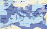
Map: Mediterranean and Northern Africa
20
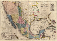
Map of the United States of Méjico (Mexico)
John Disturnell
1846 CE
21
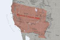
Map: Mexican Cession 1848
22
Map: Umayyad Emirate, c. 850 CE, Umayyad Caliphate, c. 950 CE
23
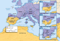
Map: Decline of Muslim Rule in the Iberian Peninsula that culminated in the Reconquista, Inquisition, and the rise of Spanish and Portuguese kingdoms, 1000-1300 CE
24
Map: Europe during the 14th Century CE
14th Century CE
25
Map: British Empire, excluding Americas, 1921 CE
1921 CE
1
-
25
of
169
<
1
2
3
4
5
6
7
>