Home
Browse
Ask Us
Chat
Harmful Language Statement
Log in
Advanced Search
Year
1920
1921
1922
1923
1924
1925
1926
1927
1928
1929
1930
1931
1932
1933
1934
1935
1936
1937
1938
1939
1940
1941
1942
1943
1944
1945
1946
1947
1948
1949
1950
1951
1952
1953
1954
1955
1956
1957
1958
1959
1960
1961
1962
1963
1964
1965
1966
1967
1968
1969
1970
1971
1972
1973
1974
1975
1976
1977
1978
1979
1980
1981
1982
1983
1984
1985
1986
1987
1988
1989
1990
1991
1992
1993
1994
1995
1996
1997
1998
1999
TO
1920
1921
1922
1923
1924
1925
1926
1927
1928
1929
1930
1931
1932
1933
1934
1935
1936
1937
1938
1939
1940
1941
1942
1943
1944
1945
1946
1947
1948
1949
1950
1951
1952
1953
1954
1955
1956
1957
1958
1959
1960
1961
1962
1963
1964
1965
1966
1967
1968
1969
1970
1971
1972
1973
1974
1975
1976
1977
1978
1979
1980
1981
1982
1983
1984
1985
1986
1987
1988
1989
1990
1991
1992
1993
1994
1995
1996
1997
1998
1999
Type
Image
739
Text
1
Format
image/jpeg
738
application/pdf
1
Collection
Peoples of Utah Revisited
31
Photo Archives
330
Ski and Snow Sports Archives
134
University Archival Photographs (P0305)
19
Utah River Running Photo Archives
225
Filters:
Genre:
"color slides"
Type:
"Image"
351
-
375
of
739
<
10
11
12
13
14
15
16
17
18
19
>
Gallery view
Number of results to display per page
10
25
50
100
200
Sort by Relevance
Sort by Title A-Z
Sort by Title Z-A
Sort by Date Ascending
Sort by Date Descending
Sort by Last Modified Ascending
Sort by Last Modified Descending
Title
Date
Type
Setname
351
One image of an eight part series of Josh Roberts performing a B/S 360 in Utah's backcountry.
1996
Image
uum_map_usa
352
One image of an eight part series of Josh Roberts performing a B/S 360 in Utah's backcountry.
1996
Image
uum_map_usa
353
Painting of Hickman Natural Bridge, Capitol Reef.
1940; 1941; 1942; 1943; 1944; 1945; 1946; 1947; 1948; 1949; 1950; 1951; 1952; 1953; 1954; 1955; 1956; 1957; 1958; 1959
Image
uum_map
354
Painting of southern Utah landscape [1]
1940; 1941; 1942; 1943; 1944; 1945; 1946; 1947; 1948; 1949; 1950; 1951; 1952; 1953; 1954; 1955; 1956; 1957; 1958; 1959
Image
uum_map
355
Painting of southern Utah landscape [2]
1940; 1941; 1942; 1943; 1944; 1945; 1946; 1947; 1948; 1949; 1950; 1951; 1952; 1953; 1954; 1955; 1956; 1957; 1958; 1959
Image
uum_map
356
Party of people viewing large landslide mass. Slide plane (surface along which mass of earth moved) is evident in photo half way down the exposed wall, sloping towards the party.
Image
uum_map
357
Paul Revere and the Raiders band playing guitars at the bottom of a lift and in front of a bonfire where other skiers are warming themselves.
1960; 1961; 1962; 1963; 1964; 1965; 1966; 1967; 1968; 1969
Image
uum_map_usa
358
Paul Revere and the Raiders band playing guitars at the bottom of a lift and in front of a bonfire where other skiers are warming themselves.
1960; 1961; 1962; 1963; 1964; 1965; 1966; 1967; 1968; 1969
Image
uum_map_usa
359
Pavement of Big Cottonwood Canyon Road, east of Salt Lake City, torn up by cloudburst flood in August 1969.
1969-08
Image
uum_map
360
People gathered at the base of a desert varnished wall.
1962-05
Image
uum_map_rr
361
People hiking in a side canyon in Glen Canyon.
1962-05
Image
uum_map_rr
362
People hiking in Glen Canyon.
1962-05
Image
uum_map_rr
363
People hiking through a rock field at the base of a rock wall.
1962-05
Image
uum_map_rr
364
People loading their boats on the Colorado River.
1962-05
Image
uum_map_rr
365
Peter Line snowboarding at U.S. Board Aid, CA. [1]
1998
Image
uum_map_usa
366
Petroglyphs in Glen Canyon.
1962-05
Image
uum_map_rr
367
Petroglyphs, Capitol Reef
1940; 1941; 1942; 1943; 1944; 1945; 1946; 1947; 1948; 1949; 1950; 1951; 1952; 1953; 1954; 1955; 1956; 1957; 1958; 1959
Image
uum_map
368
Photograph of a relief map using oblique illumination to highlight the topography. Note the steep slope along the east shore of Bear Lake. This slope marks the active Bear Lake Fault bounding the lake on the east. The lake sits in a graben, a downdropping block of earth.
Image
uum_map
369
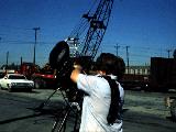
Photographer capturing images of a large truck carrying materials to build or repair a ski lift.
1960; 1961; 1962; 1963; 1964; 1965; 1966; 1967; 1968; 1969
Image
uum_map_usa
370
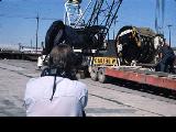
Photographer capturing images of a large truck carrying materials to build or repair a ski lift.
1960; 1961; 1962; 1963; 1964; 1965; 1966; 1967; 1968; 1969
Image
uum_map_usa
371
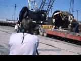
Photographer capturing images of a large truck carrying materials to build or repair a ski lift.
1960; 1961; 1962; 1963; 1964; 1965; 1966; 1967; 1968; 1969
Image
uum_map_usa
372
Photographer capturing images of a large truck carrying materials to build or repair a ski lift.
1960; 1961; 1962; 1963; 1964; 1965; 1966; 1967; 1968; 1969
Image
uum_map_usa
373
Portion of the East Bench along the mountain front in Salt Lake County. It has been dissected by strands of the Wasatch Fault. Since this photo was taken a housing development has been built on this terrain.
Image
uum_map
374
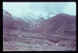
Powell's Monument, Green River, Wyo. 6-11-55
1955-06-11
Image
uum_map_rr
375
Powell's Monument, Green River, Wyo. 6-11-55
1955-06-11
Image
uum_map_rr
351
-
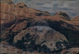
375
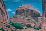
of
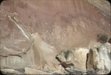
739
<
10
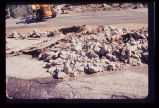
11
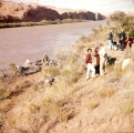
12
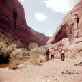
13
14
15
16
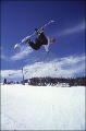
17
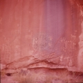
18
19
>