|
|
Title | Collection Number And Name | Photo Number |
| 176 |
 |
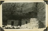
Cliff House, Fable Valley (Fred Lowrey, Honolulu) | P0013 Herbert E. Gregory Photograph Collection | P0013n09_145_1997 |
| 177 |
 |
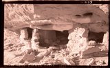
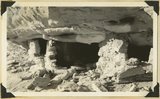
Cliff House, Fable Valley (Fred Lowrey, Honolulu) | P0013 Herbert E. Gregory Photograph Collection | P0013n09_145_1998 |
| 178 |
 |
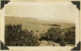
View of Allen Canyon country. Winter and summer Hogan, Piute Indians | P0013 Herbert E. Gregory Photograph Collection | P0013n09_149_2005 |
| 179 |
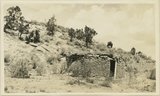 |
Rock house, Piutes. Allen Canyon, L. M. Gould, 1924 | P0013 Herbert E. Gregory Photograph Collection | P0013n09_149_2006 |
| 180 |
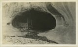 |
Cliff house north side of San Juan near Bluff | P0013 Herbert E. Gregory Photograph Collection | P0013n09_155_2014 |
| 181 |
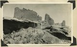 |
Ruins in Hovenweep National Monument resting on ruin of canyon tributary to McElmo. Country rock is Dakota sandstone, San Juan County, Utah, 1929. | P0013 Herbert E. Gregory Photograph Collection | P0013n10_009_2107 |
| 182 |
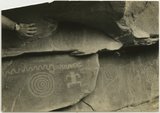 |
Indian pictographs near Mt. Carmel road. | P0013 Herbert E. Gregory Photograph Collection | P0013n10_061_2192 |
| 183 |
 |
Cliff houses in branch of Cottonwood Canyon northwest of Kanab, Kane County, Utah, 1936. | P0013 Herbert E. Gregory Photograph Collection | P0013n10_153_2350 |
| 184 |
 |
Cliff house, Kaibab Gulch, 1937 | P0013 Herbert E. Gregory Photograph Collection | P0013n10_177_2397 |
| 185 |
 |
Cliff house, Kaibab Gulch, 1937 | P0013 Herbert E. Gregory Photograph Collection | P0013n10_177_2397 |
| 186 |
 |
Kaibab Indian School, 1936. | P0013 Herbert E. Gregory Photograph Collection | P0013n10_186_2416 |
| 187 |
 |
Kaibab Indian School near Moccasin looking northeast toward head of Two Mile Wash. Deep alluvial fill. Moenkopi capped by Shinarump (upper right), Chinle and Glen Canyon beds cliffs at upper left and middle distance (Lambs Point). Branch of Sevier fault crosses divide between Two Mile Wash and Sand Creek at base of Indian Point (left middle), Mohave County, AZ. 1939 | P0013 Herbert E. Gregory Photograph Collection | P0013n11_089_2670 |
| 188 |
 |
Kaibab Indian School looking north. Alluvial flats at head of Two Mile Wash. Branch of Sevier fault passes between Navajo (left distance) and Chinle-Navajo (middle distance), Mohave County, AZ. 1939 | P0013 Herbert E. Gregory Photograph Collection | P0013n11_089_2671 |
| 189 |
 |
Settlement of Moccasin Springs looking eastward toward Kaibab Indian School. Kaibab Plateau on skyline. Mohave County, AZ. 1939 | P0013 Herbert E. Gregory Photograph Collection | P0013n11_099_2688 |
| 190 |
 |
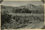
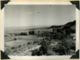
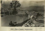
Rodadero | P0013 Herbert E. Gregory Photograph Collection | P0013n13_009_9-2963 |
| 191 |
 |
Rodadero | P0013 Herbert E. Gregory Photograph Collection | P0013n13_009_9-2964 |
| 192 |
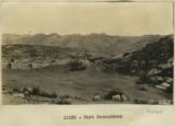 |
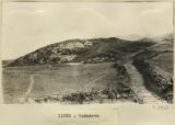
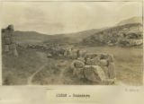
Fort Sacsuahman | P0013 Herbert E. Gregory Photograph Collection | P0013n13_010_9-2965 |
| 193 |
 |
Titicaca Island. 'Sacrificial Table.' (Near Chala). Showing Prof. Gregory. | P0013 Herbert E. Gregory Photograph Collection | P0013n13_046_9-3035 |
| 194 |
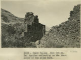 |
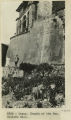
Cuzco Valley. Rumi Colca. Dr. Aguilar reflecting on the character of the stone work. | P0013 Herbert E. Gregory Photograph Collection | P0013n13_046_9-3036 |
| 195 |
 |
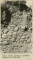
Cuzco. Inca rubble wall 100 feet farther east on the same street as St. Dominicks N.Wall. 8 ft. | P0013 Herbert E. Gregory Photograph Collection | P0013n13_047_9-3037 |
| 196 |
 |
Cuzco. Ayahuaycco quebrada. Portion of buried wall. | P0013 Herbert E. Gregory Photograph Collection | P0013n13_047_9-3038 |
| 197 |
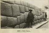 |
Wall, Cuzco | P0013 Herbert E. Gregory Photograph Collection | P0013n13_048_9-3039 |
| 198 |
 |
Nusta Espana. Excavations | P0013 Herbert E. Gregory Photograph Collection | P0013n13_049_9-3041 |
| 199 |
 |
Cuzco. Temple of the Sun. Outside wall | P0013 Herbert E. Gregory Photograph Collection | P0013n13_050_9-3043 |
| 200 |
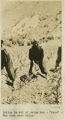 |
Indian in act of using how-'Urco'-The farm near Calca. | P0013 Herbert E. Gregory Photograph Collection | P0013n13_050_9-3044 |