Home
Browse
Ask Us
Chat
Harmful Language Statement
Log in
Advanced Search
Year
1840
1841
1842
1843
1844
1845
1846
1847
1848
1849
1850
1851
1852
1853
1854
1855
1856
1857
1858
1859
1860
1861
1862
1863
1864
1865
1866
1867
1868
1869
1870
1871
1872
1873
1874
1875
1876
1877
1878
1879
1880
1881
1882
1883
1884
1885
1886
1887
1888
1889
1890
1891
1892
1893
1894
1895
1896
1897
1898
1899
1900
1901
1902
1903
1904
1905
1906
1907
1908
1909
1910
1911
1912
1913
1914
1915
1916
1917
1918
1919
1920
1921
1922
1923
1924
1925
1926
1927
1928
1929
1930
1931
1932
1933
1934
1935
1936
1937
1938
1939
1940
1941
1942
1943
1944
1945
1946
1947
1948
1949
1950
1951
1952
1953
1954
1955
1956
1957
1958
1959
1960
1961
1962
1963
1964
1965
1966
1967
1968
1969
1970
1971
1972
1973
1974
1975
1976
1977
1978
1979
1980
1981
1982
1983
1984
1985
1986
1987
1988
1989
1990
1991
1992
1993
1994
1995
1996
1997
1998
1999
2000
2001
2002
2003
2004
2005
2006
2007
2008
TO
1840
1841
1842
1843
1844
1845
1846
1847
1848
1849
1850
1851
1852
1853
1854
1855
1856
1857
1858
1859
1860
1861
1862
1863
1864
1865
1866
1867
1868
1869
1870
1871
1872
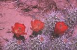
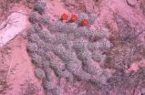
1873
1874
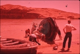
1875
1876
1877
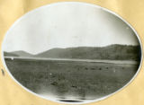
1878
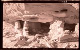
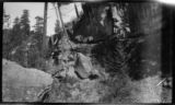
1879
1880
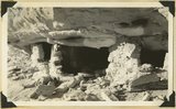
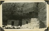
1881
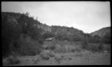
1882
1883
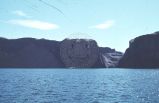
1884
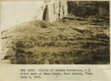
1885
1886
1887
1888
1889
1890
1891
1892
1893
1894
1895
1896
1897
1898
1899
1900
1901
1902
1903
1904
1905
1906
1907
1908
1909
1910
1911
1912
1913
1914
1915
1916
1917
1918
1919
1920
1921
1922
1923
1924
1925
1926
1927
1928
1929
1930
1931
1932
1933
1934
1935
1936
1937
1938
1939
1940
1941
1942
1943
1944
1945
1946
1947
1948
1949
1950
1951
1952
1953
1954
1955
1956
1957
1958
1959
1960
1961
1962
1963
1964
1965
1966
1967
1968
1969
1970
1971
1972
1973
1974
1975
1976
1977
1978
1979
1980
1981
1982
1983
1984
1985
1986
1987
1988
1989
1990
1991
1992
1993
1994
1995
1996
1997
1998
1999
2000
2001
2002
2003
2004
2005
2006
2007
2008
Type
Image
1,280
Image/StillImage
116
Text
53
Sound
2
Format
image/jpeg
1,392
application/pdf
115
video/mp4
2
Collection
Beckwith Photograph Collection
9
Glen Canyon
1
Hiram B. Clawson Papers
1
Mormon Settlement in Arizona
2
Photo Archives
1,304
UAIDA Main Collection
2
Utah Humanities Research Foundation
2
Utah Quilt Heritage Records
44
Utah River Running Photo Archives
139
Western Soundscape
2
Western Waters NEH
2
Westminster University Photographs
2
More
Filters:
Spatial Coverage:
"Kane County (Utah)"
201
-
225
of
1,510
<
4
5
6
7
8
9
10
11
12
13
>
Gallery view
Number of results to display per page
10
25
50
100
200
Sort by Relevance
Sort by Title A-Z
Sort by Title Z-A
Sort by Date Ascending
Sort by Date Descending
Sort by Last Modified Ascending
Sort by Last Modified Descending
Title
Date
Type
Setname
201
Chinle formation, Petrified Forest member. Head of Fossil Wood Creek. Kane County, UT. 1943
1943
Image
uum_map
202
Chinle formation, upper part; Paria Canyon 1± mile above mouth of Kitchen Canyon, Kane County, Utah, 1938.
1938
Image
uum_map
203
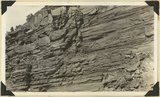
Chinle formation, upper red beds capped by remnants of Wingate sandstone. Five Pines Wash. Kane County, UT. 1943
1943
Image
uum_map
204
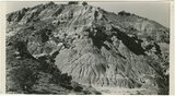
Chinle formation, upper red beds near mouth of Box Elder Canyon. Kane County, UT. 1943
1943
Image
uum_map
205
Chinle formation,upper part; Paria Canyon, viewed 1/2± miles along strike.
1938
Image
uum_map
206
Chinle formation: Petrified Forest member capped by thick sandstone beds, Paria Canyon. Kane County, Utah, 1938.
1938
Image
uum_map
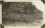
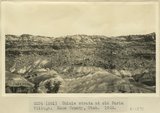
207
Chinle strata at old Paria Village. Kane County, UT. 1922
1922
Image
uum_map
208
Chinle, including Springdale marls, Wingate Kayenta Navajo. Lambs Point, 1936.
1936
Image
uum_map
209
Chrissie Bullits; Kanab, Kane County, Utah
1942
Image/StillImage
uaida_main
210
Church of Jesus Christ of Latter Day Saints Journal History dated March 10, 1866
1866-03-10
Text
uaida_main
211
Claret cups high above Escalante River [1]
1963-04-24
Image
uum_map
212
Claret cups high above Escalante River [1]
1963-04-24
Image
uum_map
213
Cleaning the boats
1957; 1958; 1959; 1960; 1961; 1962
uum_map_rr
214
Cleaning the boats
1957; 1958; 1959; 1960; 1961; 1962
uum_map_rr
215
Clear Creek junction with Escalante River
1965-09-21
Image
uum_map
216
Clearing and a hill - Navajo Lake in the background
Image
uum_map
217
Cliff house, Kaibab Gulch, 1937
1937
Image
uum_map
218
Cliff house, Kaibab Gulch, 1937
1937
Image
uum_map
219
Cliff houses in branch of Cottonwood Canyon northwest of Kanab, Kane County, Utah, 1936.
1936
Image
uum_map
220
Cliff side - on the trail from Orderville to the Esplin Ranch (16 mile journey up Muddy Canyon and northwest to the ranch)
Image
uum_map
221
Cliff side and shed near Orderville
Image
uum_map
222
Cliffs at Cannonville. Banded muds below Dakota. Lower Wahweap of Moore. Kane County, UT. 1922
1922
Image
uum_map
223
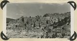
Cliffs of McElmo formation 2+ miles east of Warm Creek, Kane County, Utah. June 8, 1915.
1915
Image
uum_map
224
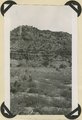
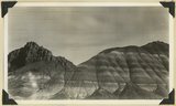
Cliffs of Tertiary limestone under rim of Paunsaugunt Plateau at a point about 7 miles NE of Alton, Kane County, Utah, in 1922.
1922
Image
uum_map
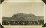
225
Cliffs of Waweap capped with Dakota. East side Dry Valley looking North. Top of Kaiparowits Plateau in distance. Kane County, UT. 1924
1924
Image
uum_map
201
-
225
of
1,510
<
4
5
6
7
8
9
10
11
12
13
>