Home
Browse
Ask Us
Chat
Harmful Language Statement
Log in
Advanced Search
Year
1847
1848
1849
1850
1851
1852
1853
1854
1855
1856
1857
1858
1859
1860
1861
1862
1863
1864
1865
1866
1867
1868
1869
1870
1871
1872
1873
1874
1875
1876
1877
1878
1879
1880
1881
1882
1883
1884
1885
1886
1887
1888
1889
1890
1891
1892
1893
1894
1895
1896
1897
1898
1899
1900
1901
1902
1903
1904
1905
1906
1907
1908
1909
1910
1911
1912
1913
1914
1915
1916
1917
1918
1919
1920
1921
1922
1923
1924
1925
1926
1927
1928
1929
1930
1931
1932
1933
1934
1935
1936
1937
1938
1939
1940
1941
1942
1943
1944
1945
1946
1947
1948
1949
1950
1951
1952
1953
1954
1955
1956
1957
1958
1959
1960
1961
1962
1963
1964
1965
1966
1967
1968
1969
1970
1971
1972
1973
1974
1975
1976
1977
1978
1979
1980
1981
1982
1983
1984
1985
1986
1987
1988
1989
1990
1991
1992
1993
1994
1995
1996
1997
1998
1999
2000
2001
2002
2003
2004
2005
2006
2007
2008
2009
2010
TO
1847
1848
1849
1850
1851
1852
1853
1854
1855
1856
1857
1858
1859
1860
1861
1862
1863
1864
1865
1866
1867
1868
1869
1870
1871
1872
1873
1874
1875
1876
1877
1878
1879
1880
1881
1882
1883
1884
1885
1886
1887
1888
1889
1890
1891
1892
1893
1894
1895
1896
1897
1898
1899
1900
1901
1902
1903
1904
1905
1906
1907
1908
1909
1910
1911
1912
1913
1914
1915
1916
1917
1918
1919
1920
1921
1922
1923
1924
1925
1926
1927
1928
1929
1930
1931
1932
1933
1934
1935
1936
1937
1938
1939
1940
1941
1942
1943
1944
1945
1946
1947
1948
1949
1950
1951
1952
1953
1954
1955
1956
1957
1958
1959
1960
1961
1962
1963
1964
1965
1966
1967
1968
1969
1970
1971
1972
1973
1974
1975
1976
1977
1978
1979
1980
1981
1982
1983
1984
1985
1986
1987
1988
1989
1990
1991
1992
1993
1994
1995
1996
1997
1998
1999
2000
2001
2002
2003
2004
2005
2006
2007
2008
2009
2010
Type
Image
483
Image/StillImage
279
Text
52
Sound
46
Image/MovingImage
3
Format
image/jpeg
833
application/pdf
78
audio/mpeg
30
video/mp4
19
Collection
Beckwith Photograph Collection
45
College of Law Publications
1
Hiram B. Clawson Papers
4
Home Movie Collection
3
Jacob Myers Sr. Papers, 1801-2009
1
Photo Archives
611
Ski and Snow Sports Archives
13
UAIDA Main Collection
19
Uintah County Regional History Center...
1
Utah Humanities Research Foundation
23
Utah Quilt Heritage Records
6
Utah River Running Photo Archives
164
Western Soundscape
46
Western Waters NEH
16
Westminster College Photographs
24
More
Filters:
Spatial Coverage:
"Washington County (Utah)"
526
-
550
of
977
<
17
18
19
20
21
22
23
24
25
26
>
Gallery view
Number of results to display per page
10
25
50
100
200
Sort by Relevance
Sort by Title A-Z
Sort by Title Z-A
Sort by Date Ascending
Sort by Date Descending
Sort by Last Modified Ascending
Sort by Last Modified Descending
Title
Date
Type
Setname
526
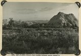
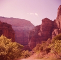
Part of Kolob volcanic field looking southeast across canyons of Virgin River to Moccasin Terrace (skyline). Lava (foreground) has buried rough topography developed on Chinle and Navajo. Above it rises island like Pine Valley Peak of Navajo sandstone (upper right). Towers of Zion (upper left). Washington County, UT, 1942
1942
Image
uum_map
527
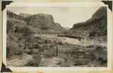
Parunuweap Canyon near east boundary of Zion Park, Utah, 1936.
1936
Image
uum_map
528
Parunuweap Canyon, looking NW toward the Watchman. Springdale member center cliffs, Utah, 1936.
1936
Image
uum_map
529
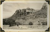
Parunuweap formation overlying Moenkopi; on divide between two tributaries to Virgin River near Grafton. Washington County, UT, 1942
1942
Image
uum_map
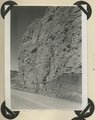
530
Parunuweap formation, covered by basalt flow. La Verkin Canyon, Washington County, UT, 1942
1942
Image
uum_map
531
Parunuweap formation, covered by basalt flow. La Verkin Canyon, Washington County, UT, 1942
1942
Image
uum_map
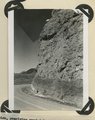
532
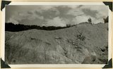
Parunuweap formation, overlying eroded Moenkopi strata. Federal highway 15, Virgin River Valley, near Grafton. Washington County, UT, 1942
1942
Image
uum_map
533
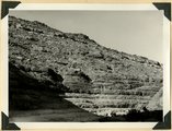
Parunuweap formation, Pliocene?, overlying Moenkopi beds (concealed by talus) and capped by basalt. Lower La Verkin Canyon, Washington County, UT, 1943
1943
Image
uum_map
534
Patriarchs, Zion National Park.
1957
Image
uum_map
535
Perched pot holes, Pine Creek, near east end of tunnel, Zion National Park, Utah, 1936.
1936
Image
uum_map
536
Perched potholes in Navajo sandstone Pine Creek, Zion National Park, Utah, 1932.
1932
Image
uum_map
537
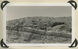
Permian-Triassic contact in Goulds Canyon (of little Creek). Kaibab (lowest ledge), conglomerate (second ledge), Moenkopi (third ledge and top). Washington County, UT. 1939
1939
Image
uum_map
538
Petrified forest member of the Chinle formation, Taylor Creek. Washington County, UT, 1940
1940
Image
uum_map
539
Petrified log near base of Chinle, north of Rockville. Zion National Park
1937; 1938
Image
uum_map
540
Petroglyphs and pictographs [20]
1930; 1931; 1932; 1933; 1934; 1935; 1936; 1937; 1938; 1939; 1940; 1941; 1942; 1943; 1944; 1945; 1946; 1947; 1948; 1949; 1950
Image
uum_map_rr
541
Phainopepla song in southern Utah (100409)
2010-04-09
Sound
uu_wss
542
Photographs from the manuscript: "Mormon Towns and Trails: Followed by Gaskell Romney, with his parents in the 1880's, and with his his children in 1941." - "St. George Temple, view from the South."
1941
Image
uum_map
543
Photographs from the manuscript: "Mormon Towns and Trails: Followed by Gaskell Romney, with his parents in the 1880's, and with his his children in 1941." - "The St. George Tabernacle."
1941
Image
uum_map
544
Photographs from the Manuscript "Mormon Towns and Trails: Followed by Gaskell Romney, with his parents in the 1880's and with his children in 1941" - Father's (Gaskell Romney) home and birth place in St. George, built by grandfather Miles P. Romney."
1941
Image
uum_map
545
Photographs from the Manuscript "Mormon Towns and Trails: Followed by Gaskell Romney, with his parents in the the 1880's and with his children in 1941" - "St. George from the Tabernacle balcony."
1941
Image
uum_map
546
Pine Valley Days
1946-07-02
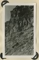
Text
uum_uhrf
547
Pine Valley Mountains in winter
1937; 1938; 1939; 1940; 1941; 1942; 1943; 1944; 1945; 1946; 1947; 1948; 1949; 1950; 1951; 1952; 1953; 1954; 1955; 1956; 1957; 1958; 1959; 1960; 1961; 1962; 1963; 1964; 1965; 1966; 1967; 1968; 1969; 1970
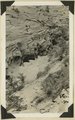
Image
uum_map_rr
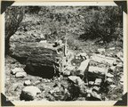
548
Playbills for plays presented by the St. George Dramatics Group (1880-1882)
1880; 1882
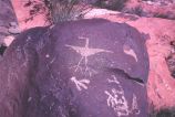
Text
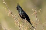
uum_uhrf
549
Portrait of George Ellwanger.
1870; 1871; 1872; 1873; 1874; 1875; 1876; 1877; 1878; 1879; 1880; 1881; 1882; 1883; 1884; 1885; 1886; 1887; 1888; 1889; 1890; 1891; 1892; 1893; 1894; 1895; 1896; 1897; 1898; 1899
uum_map
550
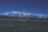
Possibly a mill in Silver Reef, Utah.
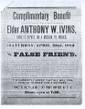
1880; 1881; 1882; 1883; 1884; 1885; 1886; 1887; 1888; 1889; 1890
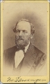
uum_map
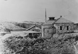
526
-
550
of
977
<
17
18
19
20
21
22
23
24
25
26
>