Home
Browse
Ask Us
Chat
Harmful Language Statement
Log in
Advanced Search
Year
1847
1848
1849
1850
1851
1852
1853
1854
1855
1856
1857
1858
1859
1860
1861
1862
1863
1864
1865
1866
1867
1868
1869
1870
1871
1872
1873
1874
1875
1876
1877
1878
1879
1880
1881
1882
1883
1884
1885
1886
1887
1888
1889
1890
1891
1892
1893
1894
1895
1896
1897
1898
1899
1900
1901
1902
1903
1904
1905
1906
1907
1908
1909
1910
1911
1912
1913
1914
1915
1916
1917
1918
1919
1920
1921
1922
1923
1924
1925
1926
1927
1928
1929
1930
1931
1932
1933
1934
1935
1936
1937
1938
1939
1940
1941
1942
1943
1944
1945
1946
1947
1948
1949
1950
1951
1952
1953
1954
1955
1956
1957
1958
1959
1960
1961
1962
1963
1964
1965
1966
1967
1968
1969
1970
1971
1972
1973
1974
1975
1976
1977
1978
1979
1980
1981
1982
1983
1984
1985
1986
1987
1988
1989
1990
1991
1992
1993
1994
1995
1996
1997
1998
1999
2000
2001
2002
2003
2004
2005
2006
2007
2008
2009
2010
TO
1847
1848
1849
1850
1851
1852
1853
1854
1855
1856
1857
1858
1859
1860
1861
1862
1863
1864
1865
1866
1867
1868
1869
1870
1871
1872
1873
1874
1875
1876
1877
1878
1879
1880
1881
1882
1883
1884
1885
1886
1887
1888
1889
1890
1891
1892
1893
1894
1895
1896
1897
1898
1899
1900
1901
1902
1903
1904
1905
1906
1907
1908
1909
1910
1911
1912
1913
1914
1915
1916
1917
1918
1919
1920
1921
1922
1923
1924
1925
1926
1927
1928
1929
1930
1931
1932
1933
1934
1935
1936
1937
1938
1939
1940
1941
1942
1943
1944
1945
1946
1947
1948
1949
1950
1951
1952
1953
1954
1955
1956
1957
1958
1959
1960
1961
1962
1963
1964
1965
1966
1967
1968
1969
1970
1971
1972
1973
1974
1975
1976
1977
1978
1979
1980
1981
1982
1983
1984
1985
1986
1987
1988
1989
1990
1991
1992
1993
1994
1995
1996
1997
1998
1999
2000
2001
2002
2003
2004
2005
2006
2007
2008
2009
2010
Type
Image
483
Image/StillImage
279
Text
52
Sound
46
Image/MovingImage
3
Format
image/jpeg
833
application/pdf
78
audio/mpeg
30
video/mp4
19
Collection
Beckwith Photograph Collection
45
College of Law Publications
1
Hiram B. Clawson Papers
4
Home Movie Collection
3
Jacob Myers Sr. Papers, 1801-2009
1
Photo Archives
611
Ski and Snow Sports Archives
13
UAIDA Main Collection
19
Uintah County Regional History Center...
1
Utah Humanities Research Foundation
23
Utah Quilt Heritage Records
6
Utah River Running Photo Archives
164
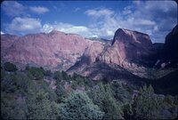
Western Soundscape
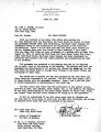
46
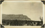
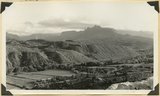
Western Waters NEH
16
Westminster College Photographs
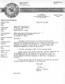
24
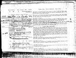
More
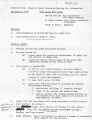
Filters:
Spatial Coverage:
"Washington County (Utah)"
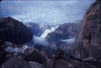
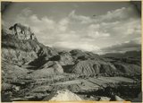
376
-
400
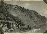
of
977
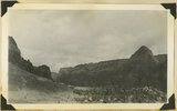
<
11
12
13
14
15
16
17
18
19
20
>
Gallery view
Number of results to display per page
10
25
50
100
200
Sort by Relevance
Sort by Title A-Z
Sort by Title Z-A
Sort by Date Ascending
Sort by Date Descending
Sort by Last Modified Ascending
Sort by Last Modified Descending
Title
Date
Type
Setname
376
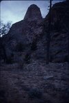
Kolob Canyon, Zion, Spring 1987 [20]
1987
Image/StillImage
uum_map_rr
377
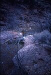
Kolob Canyon, Zion, Spring 1987 [21]
1987
Image/StillImage
uum_map_rr
378
Kolob Canyon, Zion, Spring 1987 [22]
1987
Image/StillImage
uum_map_rr
379
Kolob Canyon, Zion, Spring 1987 [23]
1987
Image/StillImage
uum_map_rr
380
Kolob Canyon, Zion, Spring 1987 [24]
1987
Image/StillImage
uum_map_rr
381
Kolob Canyon, Zion, Spring 1987 [25]
1987
Image/StillImage
uum_map_rr
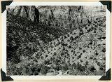
382
Kolob cliffs and landforms
1987
Image/StillImage
uum_map_rr
383
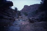
Kolob Creek runoff and proposals, 1951-1952
1951; 1952
Text
wwdl_neh
384
Kolob Plateau
1936
Image
uum_map
385
Kolob plateau, general surface. Pink cliffs in background, 1936.
1936
Image
uum_map
386
Kolob Project papers relating to Cedar City
1953; 1954; 1958; 1969; 1972; 1977
Text
wwdl_neh
387
Kolob Reservoir documents
1953; 1954; 1955; 1959; 1980
Text
wwdl_neh
388
Kolob Reservoir water rights documents
1952; 1955; 1956; 1958; 1974; 1975; 1980
Text
wwdl_neh
389
Kolob-Cedar City Project documents, 1974-1979
1952; 1972; 1974; 1977; 1979
Text
wwdl_neh
390
Kolob-Cedar City Project financing
1978
Text
wwdl_neh
391
Kolob-Rosy Seth Project documents
1973; 1975; 1977
Text
wwdl_neh
392
La Verkin Breaks, looking west, Navajo sandstone capped by Carmel limestone and cut by canyons 800 to 2,000 feet deep, Pine Valley Mountains in distance, Washington County, UT, 1939
1939
Image
uum_map
393
Ladder-backed Woodpecker calls (100408)
2010-04-08
Sound
uu_wss
394
Lambs Point. Chinle including prominent Springdale member from base to highest cliff step, which is combined Wingate and Navajo. Kane County, Utah, 1936.
1936
Image
uum_map
395
Landslide (all the material in view) near mouth of Birch Creek, Zion Canyon. Covers upper part of and Springdale member (lower left) of the Chinle. Still active: Virgin river flows in groove at left of road, Washington County, UT, 1939
1939
Image
uum_map
396
Landslide (right) covered by talus, Zion Canyon, 1936.
1936
Image
uum_map
397
Landslide at mouth of Parunuweap (right center) extends from south of Springdale (foreground) across Parunuweap to base of Eagle Crags (top center). Involves entire Chinle formation. Washington County, UT. 1939
1939
Image
uum_map
398
Landslide in Chinle formation from base of Navajo Mountains Sandstone, Springdale member of Chinle (middle right). Near headquarters, Zion National Park, UT. 1939
1939
Image
uum_map
399
Landslide, 1 mile south of Springdale, covers strata from base of Navajo (top left) to Shinarump. Springdale member of Chinle (left middle). Washington County, UT. 1939
1939
Image
uum_map
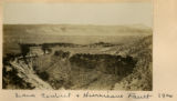
400
Lava Contact & Hurricane Fault, 1900
1900
Image
uum_map
376
-
400
of
977
<
11
12
13
14
15
16
17
18
19
20
>