| Title | Date | Type | Setname | ||
|---|---|---|---|---|---|
| 701 |
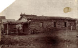 |
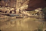
First schoolhouse and church in Bluff, Utah, 1880. | 1880; 1881; 1882; 1883; 1884; 1885; 1886; 1887; 1888; 1889; 1890; 1891; 1892; 1893; 1894; 1895; 1896; 1897; 1898; 1899; 1900; 1901; 1902; 1903; 1904; 1905; 1906; 1907; 1908; 1909; 1910 | Image | uum_map |
| 702 |
 |
First settlement of the Nevills "Old Canyon" Camp, Sand Draw Canyon, Mexican Hat, Utah. | 1920; 1921; 1922; 1923; 1924; 1925; 1926; 1927; 1928; 1929 | Image | uum_map_rr |
| 703 |
 |
First view of Rainbow Bridge coming up Bridge Canyon | 1963-04-25 | Image | uum_map |
| 704 |
 |
First White Men in San Juan County, Utah | 1928; 1929; 1930; 1931; 1932; 1933 | Text | uaida_main |
| 705 |
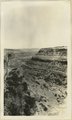 |
Fish Canyon near its head. Coconino(?) over Supai(?). Comb monocline in the distance. San Juan County, UT, 1927 | 1927 | Image | uum_map |
| 706 |
 |
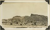
Five Kiva Ruin, Westwater Creek near Blanding, Utah | Image | uum_map | |
| 707 |
 |
Five Kiva Ruin, Westwater Creek near Blanding, Utah [2] | Image | uum_map | |
| 708 |
 |
Five Kiva Ruin, Westwater Creek near Blanding, Utah [3] | Image | uum_map | |
| 709 |
 |
Five Kiva Ruin, Westwater Creek near Blanding, Utah [4] | Image | uum_map | |
| 710 |
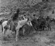 |
Five men on saddle horses in southern Utah. | 1890; 1891; 1892; 1893; 1894; 1895; 1896; 1897; 1898; 1899; 1900 | Image | uum_map_rr |
| 711 |
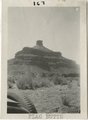 |
Flag Butte, Garden of the Gods | 1925; 1926; 1927; 1928; 1929; 1930; 1931; 1932; 1933; 1934; 1935; 1936; 1937; 1938; 1939; 1940; 1941; 1942; 1943; 1944; 1945; 1946; 1947; 1948; 1949 | Image | uum_map_rr |
| 712 |
 |
Flat chimney | 1925; 1926; 1927; 1928; 1929; 1930; 1931; 1932; 1933; 1934; 1935; 1936; 1937; 1938; 1939; 1940; 1941; 1942; 1943; 1944; 1945; 1946; 1947; 1948; 1949 | Image | uum_map_rr |
| 713 |
 |
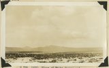
Flood stage, 1929, San Juan | 1929 | Image | uum_map_rr |
| 714 |
 |
Floor of White Canyon and tributaries looking northeast from point near Owochomo natural bridge. "Kachina" (Cedar Mesa) sandstone (foreground), "Frey" (Organ Rock) (first mesas), Moenkopi, Shinarump and Wingate (background). San Juan County, Utah, 1932. | 1932 | Image | uum_map |
| 715 |
 |
Floor of White Canyon near Rock Springs. "Kachina" (Cedar Mesa) sandstone (at base), "Frey" (Organ Rock), Moenkopi, Shinarump (remains at top), San Juan County, Utah, 1932. | 1932 | Image | uum_map |
| 716 |
 |
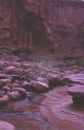
Forbidden Canyon | 1963-04-25 | Image | uum_map |
| 717 |
 |
Forbidden Canyon ruins | 1934; 1935; 1936; 1937; 1938; 1939; 1940; 1941; 1942; 1943; 1944; 1945; 1946; 1947; 1948; 1949 | Image/StillImage | uum_map_rr |
| 718 |
 |
Forbidden Canyon scene [1] | 1963-04-25 | Image | uum_map |
| 719 |
 |
Forbidden Canyon scene [2] | 1963-04-25 | Image | uum_map |
| 720 |
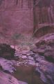 |
Forbidden Canyon scene [3] | 1963-04-25 | Image | uum_map |
| 721 |
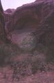 |
Forbidden Canyon scene, high very large cave | 1963-04-25 | Image | uum_map |
| 722 |
 |
Forbidden Canyon, junction with Bridge Canyon | 1963-04-25 | Image | uum_map |
| 723 |
 |
Forbidding and Bridge Canyons | 1925; 1926; 1927; 1928; 1929; 1930; 1931; 1932; 1933; 1934; 1935; 1936; 1937; 1938; 1939; 1940; 1941; 1942; 1943; 1944; 1945; 1946; 1947; 1948; 1949 | Image | uum_map_rr |
| 724 |
 |
Formation at the Forbidden Canyon fork | 1957; 1958; 1959; 1960; 1961; 1962 | uum_map_rr | |
| 725 |
 |
Formation at the Forbidden Canyon fork | 1957; 1958; 1959; 1960; 1961; 1962 | uum_map_rr |