Home
Browse
Ask Us
Chat
Harmful Language Statement
Log in
Advanced Search
Year
1872
1873
1874
1875
1876
1877
1878
1879
1880
1881
1882
1883
1884
1885
1886
1887
1888
1889
1890
1891
1892
1893
1894
1895
1896
1897
1898
1899
1900
1901
1902
1903
1904
1905
1906
1907
1908
1909
1910
1911
1912
1913
1914
1915
1916
1917
1918
1919
1920
1921
1922
1923
1924
1925
1926
1927
1928
1929
1930
1931
1932
1933
1934
1935
1936
1937
1938
1939
1940
1941
1942
1943
1944
1945
1946
1947
1948
1949
1950
1951
1952
1953
1954
1955
1956
1957
1958
1959
1960
1961
1962
1963
1964
1965
1966
1967
1968
1969
1970
1971
1972
1973
1974
1975
1976
1977
1978
1979
1980
1981
1982
1983
1984
1985
1986
1987
1988
1989
1990
1991
1992
1993
1994
1995
1996
1997
1998
1999
2000
2001
2002
2003
2004
2005
2006
2007
2008
2009
2010
TO
1872
1873
1874
1875
1876
1877
1878
1879
1880
1881
1882
1883
1884
1885
1886
1887
1888
1889
1890
1891
1892
1893
1894
1895
1896
1897
1898
1899
1900
1901
1902
1903
1904
1905
1906
1907
1908
1909
1910
1911
1912
1913
1914
1915
1916
1917
1918
1919
1920
1921
1922
1923
1924
1925
1926
1927
1928
1929
1930
1931
1932
1933
1934
1935
1936
1937
1938
1939
1940
1941
1942
1943
1944
1945
1946
1947
1948
1949
1950
1951
1952
1953
1954
1955
1956
1957
1958
1959
1960
1961
1962
1963
1964
1965
1966
1967
1968
1969
1970
1971
1972
1973
1974
1975
1976
1977
1978
1979
1980
1981
1982
1983
1984
1985
1986
1987
1988
1989
1990
1991
1992
1993
1994
1995
1996
1997
1998
1999
2000
2001
2002
2003
2004
2005
2006
2007
2008
2009
2010
Type
Image
1,955
Image/StillImage
1,542
Text
286
Image/MovingImage
5
Sound
1
Format
image/jpeg
3,365
application/pdf
727
video/mp4
5
audio/mpeg
1
Collection
Beckwith Photograph Collection
2
Home Movie Collection
5
Photo Archives
1,412
Ski and Snow Sports Archives
43
UAIDA Main Collection
948
Utah Humanities Research Foundation
25
Utah Quilt Heritage Records
2
Utah River Running Photo Archives
1,665
Western Soundscape
1
Western Waters NEH
1
More
Filters:
Spatial Coverage:
"San Juan County (Utah)"
651
-
675
of
4,104
<
22
23
24
25
26
27
28
29
30
31
>
Gallery view
Number of results to display per page
10
25
50
100
200
Sort by Relevance
Sort by Title A-Z
Sort by Title Z-A
Sort by Date Ascending
Sort by Date Descending
Sort by Last Modified Ascending
Sort by Last Modified Descending
Title
Date
Type
Setname
651
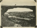
Edwin Bridge, or Owachomo Bridge, in Bridges National Monument. The figure is Dan Perkins and his horse
1925
Image
uum_map
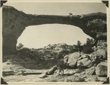
652
Edwin Bridge, or Owachomo Bridge, in Bridges National Monument. The figure is Dan Perkins and his horse
1925
Image
uum_map
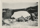
653
Edwin Natural Bridge
1930
Image
uum_map_rr
654
Edwin Natural Bridge
1930
Image
uum_map_rr
655
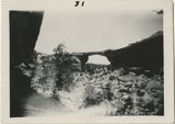
EdwNatural Bridges expedition, 1921: in Natural Bridge
1921-06
Image/StillImage
uum_map
656
Elderly men near car.
1958
Image
uum_map
657
Elk Mountain, 1930
1930
Image
uum_map_rr
658
Embarkation at Mexican Hat
1949
uum_map_rr
659
End of a day: U.S. Gov. packtrain at the Natural Bridges
1920; 1921; 1922; 1923
uum_map
660
Entrada(?) on back of Comb monocline. Butler Wash, 11 miles above its mouth, maybe a sandstone below Entrada. View taken standing on Navajo. San Juan County, UT, 1928
1928
Image
uum_map
661
Entrada, Carmel (?) Navajo, east side. Allen Canyon near Mancos Jim Butte. San Juan County, UT, 1927
1927
Image
uum_map
662
Entrance facade of the Nevills Mexican Hat Lodge beside the San Juan River, opened in 1933.
1936-03
Image
uum_map_rr
663
Entrance into San Juan Canyon just below mouth of Chinle Creek. Canyon in Goodridge formation. Looking southwest. 1921. San Juan County, UT
1921
Image
uum_map
664
Entrance into San Juan Canyon just below mouth of Chinle Creek. Canyon in Goodridge formation. Looking southwest. 1921. San Juan County, UT
1921
Image
uum_map
665
Entrance to Aztec Canyon by Lake Powell.
1963; 1964; 1965; 1966; 1967
uum_map_rr
666
Entrance to Aztec Canyon by Lake Powell.
1963; 1964; 1965; 1966; 1967
uum_map_rr
667
Entrance to Aztec Canyon by Lake Powell.
1963; 1964; 1965; 1966; 1967
uum_map_rr
668
Entrance to Aztec Canyon by Lake Powell.
1963; 1964; 1965; 1966; 1967
uum_map_rr
669
Entrance to Aztec Canyon by Lake Powell.
1963; 1964; 1965; 1966; 1967
uum_map_rr
670
Entrance to Aztec Canyon by Lake Powell.
1963; 1964; 1965; 1966; 1967
uum_map_rr
671
Entrance to Aztec Canyon by Lake Powell.
1963; 1964; 1965; 1966; 1967
uum_map_rr
672
Entrance to Forbidden Canyon (old bar now buried at least 50 feet)
1963-04-25
Image
uum_map
673
Entrenched meanders, San Juan River used in USGS Prof. Paper 96
1909
Image
uum_map
674
Erosion forms in Entrada sandstone north branch of Whiskers Creek, looking south, San Juan County, UT, 1928
1928
Image
uum_map
675
Erosion forms. Morrison, just above heavy sandstone bed near base. Near mouth of Recapture Creek, San Juan County, UT, 1928
1928
Image
uum_map
651
-
675
of
4,104
<
22
23
24
25
26
27
28
29
30
31
>