Home
Browse
Ask Us
Chat
Harmful Language Statement
Log in
Advanced Search
Year
1872
1873
1874
1875
1876
1877
1878
1879
1880
1881
1882
1883
1884
1885
1886
1887
1888
1889
1890
1891
1892
1893
1894
1895
1896
1897
1898
1899
1900
1901
1902
1903
1904
1905
1906
1907
1908
1909
1910
1911
1912
1913
1914
1915
1916
1917
1918
1919
1920
1921
1922
1923
1924
1925
1926
1927
1928
1929
1930
1931
1932
1933
1934
1935
1936
1937
1938
1939
1940
1941
1942
1943
1944
1945
1946
1947
1948
1949
1950
1951
1952
1953
1954
1955
1956
1957
1958
1959
1960
1961
1962
1963
1964
1965
1966
1967
1968
1969
1970
1971
1972
1973
1974
1975
1976
1977
1978
1979
1980
1981
1982
1983
1984
1985
1986
1987
1988
1989
1990
1991
1992
1993
1994
1995
1996
1997
1998
1999
2000
2001
2002
2003
2004
2005
2006
2007
2008
2009
2010
TO
1872
1873
1874
1875
1876
1877
1878
1879
1880
1881
1882
1883
1884
1885
1886
1887
1888
1889
1890
1891
1892
1893
1894
1895
1896
1897
1898
1899
1900
1901
1902
1903
1904
1905
1906
1907
1908
1909
1910
1911
1912
1913
1914
1915
1916
1917
1918
1919
1920
1921
1922
1923
1924
1925
1926
1927
1928
1929
1930
1931
1932
1933
1934
1935
1936
1937
1938
1939
1940
1941
1942
1943
1944
1945
1946
1947
1948
1949
1950
1951
1952
1953
1954
1955
1956
1957
1958
1959
1960
1961
1962
1963
1964
1965
1966
1967
1968
1969
1970
1971
1972
1973
1974
1975
1976
1977
1978
1979
1980
1981
1982
1983
1984
1985
1986
1987
1988
1989
1990
1991
1992
1993
1994
1995
1996
1997
1998
1999
2000
2001
2002
2003
2004
2005
2006
2007
2008
2009
2010
Type
Image
1,955
Image/StillImage
1,542
Text
286
Image/MovingImage
5
Sound
1
Format
image/jpeg
3,365
application/pdf
727
video/mp4
5
audio/mpeg
1
Collection
Beckwith Photograph Collection
2
Home Movie Collection
5
Photo Archives
1,412
Ski and Snow Sports Archives
43
UAIDA Main Collection
948
Utah Humanities Research Foundation
25
Utah Quilt Heritage Records
2
Utah River Running Photo Archives
1,665
Western Soundscape
1
Western Waters NEH
1
More
Filters:
Spatial Coverage:
"San Juan County (Utah)"
626
-
650
of
4,104
<
21
22
23
24
25
26
27
28
29
30
>
Gallery view
Number of results to display per page
10
25
50
100
200
Sort by Relevance
Sort by Title A-Z
Sort by Title Z-A
Sort by Date Ascending
Sort by Date Descending
Sort by Last Modified Ascending
Sort by Last Modified Descending
Title
Date
Type
Setname
626
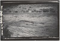
Drift in San Juan at Honaker Trail after 4 ft. rise. August 9, 1921
1921-08-09
Image/StillImage
uum_map
627
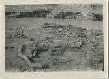
Driftwood by San Juan
1925; 1926; 1927; 1928; 1929; 1930; 1931; 1932; 1933; 1934; 1935; 1936; 1937; 1938; 1939; 1940; 1941; 1942; 1943; 1944; 1945; 1946; 1947; 1948; 1949
Image
uum_map_rr
628
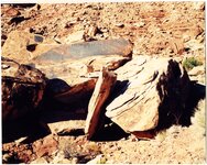
Duckhead Man petroglyph, Cedar Mesa, Utah 1990s
1994; 1995; 1996; 1997
Image/StillImage
uum_map_rr
629
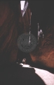
Dungeon Canyon, 1961.
1961
Image
uum_map
630
Early Bluff, Utah
1944; 1945; 1946; 1947; 1948; 1949; 1950
Text
uum_uhrf
631
Early morning from Caroline Bridge, Bridges National Monument, UT
1925
Image
uum_map
632
Earth Pillars. Pahute Canyon, Utah, 1910 (Photo G169)
1910
Image
uum_map
633
East Bears Ear
1930
Image
uum_map_rr
634
East Carbon vs. Monticello (15-20), 1973: football
1973
Image/MovingImage
uum_hmc
635
East Carbon vs. Monticello, 1972: football
1972
Image/MovingImage
uum_hmc
636
East Carbon vs. San Juan, 1972: football
1972
Image/MovingImage
uum_hmc
637
East Dome, Mexican Hat
1924-01-11
Image
uum_map_rr
638
East edge of Raplee monocline. San Juan County, UT 1928
1928
Image
uum_map
639
East of Hite, Utah on new graded section
1966-07-26
Image
uum_map
640
East side of Butler Wash, 77 Miles above its mouth. View taken standing on Navajo sandstone. Carmel (?), Entrada (?), Summerville (?), Salt Wahs (?), Morrison Shales, Dakota, San Juan County, Utah, 1928.
Image
uum_map
641
East side of Butler Wash, 77 Miles above its mouth. View taken standing on Navajo sandstone. Carmel (?), Entrada (?), Summerville (?), Salt Wahs (?), Morrison Shales, Dakota, San Juan County, Utah, 1928.
1928
Image
uum_map
642
East wall of Comb Wash includes Chinle, Wingate, Todilto, Navajo near mouth of Arch Canyon. San Juan County, UT. 1925
1925
Image
uum_map
643
EastCarbon vs. Morgan 1969
1969
Image/MovingImage
uum_hmc
644
Ed Black, Indian Agent, and family; Allen Canyon, San Juan County, Utah
1936
Image/StillImage
uaida_main
645
Edge of Comb looking SW 2± mi. NW of Garnet Ridge 1914
1914
Image
uum_map
646
Edge of lower bench, Garnet Ridge (McElmo?), 1914
1914
Image
uum_map
647
Edwin Bridge
1930
Image
uum_map_rr
648
Edwin Bridge
1920; 1921; 1922; 1923; 1924; 1925; 1926; 1927; 1928; 1929; 1930; 1931; 1932; 1933; 1934; 1935; 1936; 1937; 1938; 1939; 1940; 1941; 1942; 1943; 1944; 1945; 1946; 1947; 1948; 1949
Image/StillImage
uum_map_rr
649
Edwin Bridge looking north
1928-08
Image
uum_map_rr
650
Edwin Bridge or Owachomo Bridge, in Bridges National Monument. The figure is Dan Perkins and his horse Cap
1925
Image
uum_map
626
-
650
of
4,104
<
21
22
23
24
25
26
27
28
29
30
>