Home
Browse
Ask Us
Chat
Harmful Language Statement
Log in
Advanced Search
Year
1872
1873
1874
1875
1876
1877
1878
1879
1880
1881
1882
1883
1884
1885
1886
1887
1888
1889
1890
1891
1892
1893
1894
1895
1896
1897
1898
1899
1900
1901
1902
1903
1904
1905
1906
1907
1908
1909
1910
1911
1912
1913
1914
1915
1916
1917
1918
1919
1920
1921
1922
1923
1924
1925
1926
1927
1928
1929
1930
1931
1932
1933
1934
1935
1936
1937
1938
1939
1940
1941
1942
1943
1944
1945
1946
1947
1948
1949
1950
1951
1952
1953
1954
1955
1956
1957
1958
1959
1960
1961
1962
1963
1964
1965
1966
1967
1968
1969
1970
1971
1972
1973
1974
1975
1976
1977
1978
1979
1980
1981
1982
1983
1984
1985
1986
1987
1988
1989
1990
1991
1992
1993
1994
1995
1996
1997
1998
1999
2000
2001
2002
2003
2004
2005
2006
2007
2008
2009
2010
TO
1872
1873
1874
1875
1876
1877
1878
1879
1880
1881
1882
1883
1884
1885
1886
1887
1888
1889
1890
1891
1892
1893
1894
1895
1896
1897
1898
1899
1900
1901
1902
1903
1904
1905
1906
1907
1908
1909
1910
1911
1912
1913
1914
1915
1916
1917
1918
1919
1920
1921
1922
1923
1924
1925
1926
1927
1928
1929
1930
1931
1932
1933
1934
1935
1936
1937
1938
1939
1940
1941
1942
1943
1944
1945
1946
1947
1948
1949
1950
1951
1952
1953
1954
1955
1956
1957
1958
1959
1960
1961
1962
1963
1964
1965
1966
1967
1968
1969
1970
1971
1972
1973
1974
1975
1976
1977
1978
1979
1980
1981
1982
1983
1984
1985
1986
1987
1988
1989
1990
1991
1992
1993
1994
1995
1996
1997
1998
1999
2000
2001
2002
2003
2004
2005
2006
2007
2008
2009
2010
Type
Image
1,955
Image/StillImage
1,542
Text
286
Image/MovingImage
5
Sound
1
Format
image/jpeg
3,365
application/pdf
727
video/mp4
5
audio/mpeg
1
Collection
Beckwith Photograph Collection
2
Home Movie Collection
5
Photo Archives
1,412
Ski and Snow Sports Archives
43
UAIDA Main Collection
948
Utah Humanities Research Foundation
25
Utah Quilt Heritage Records
2
Utah River Running Photo Archives
1,665
Western Soundscape
1
Western Waters NEH
1
More
Filters:
Spatial Coverage:
"San Juan County (Utah)"
351
-
375
of
4,104
<
10
11
12
13
14
15
16
17
18
19
>
Gallery view
Number of results to display per page
10
25
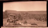
50
100
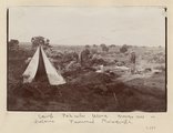
200
Sort by Relevance
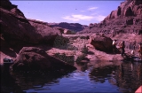
Sort by Title A-Z
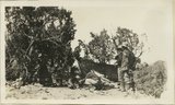
Sort by Title Z-A
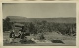
Sort by Date Ascending
Sort by Date Descending
Sort by Last Modified Ascending
Sort by Last Modified Descending
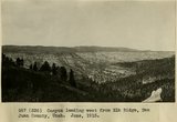
Title
Date
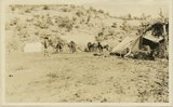
Type
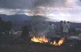
Setname
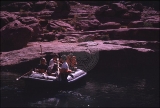
351
Butte of Morrison shale capped by Dakota rising from a floor of Morrison(?) sand stone(Salt Wash). Near Mouth of Recapture Creek. San Juan County, UT, 1928
1928
Image
uum_map
352
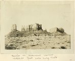
Buttes in Monument Valley, Utah (Hopkins, Salt Lake City, photo)
1909
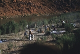
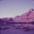
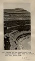
Image
uum_map
353
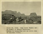
Camp above Meskin Bar on summit of navajo sandstone. Buttes in background are on south side of Colorado
1922
Image
uum_map
354
Camp in Lake Canyon. Walls of Navajo Sandstone. San Juan County, UT, 1927
1927
Image
uum_map
355
Camp in San Juan Canyon near mouth of Johns Canyon. Lower Part of wall formed by Goodridge formation and upper part by Moonlight sandstone and Hermit shale. San Juan County, UT. 1921
1921
Image
uum_map
356
Camp on Navajo sandstone east of Castle uplift, San Juan County, UT, 1925
1925
Image
uum_map
357
Camp on San Juan: morning
1954; 1955; 1956; 1957; 1958; 1959; 1960; 1961
Image
uum_map_rr
358
Camp Piute Indians, Allen Canyon, San Juan County, UT 1925
1925
Image
uum_map
359
Camp scene near Allen Canyon. Piute summer shelter. Edna Hope Gregory, A.A. Baker and McKnight. San Juan County, UT, 1927
1927
Image
uum_map
360
Camp scene, south bank of Armstrong Canyon looking northeast. Camp on Coconino; plateau in middle distance. Moenkopi capped by Shinarump; mesa in left background. Chinle and Glen Canyon, Fred Lowrey. San Juan County, UT, 1928
Image
uum_map
361
Camp scene, south bank of Armstrong Canyon looking northeast. Camp on Coconino; plateau in middle distance. Moenkopi capped by Shinarump; mesa in left background. Chinle and Glen Canyon, Fred Lowrey. San Juan County, UT, 1928
1928
Image
uum_map
362
Camp scene. Elk Ridge near head Butte Canyon branch of arch Canyon. A.A. Baker and Edna Hope Gregory. San Juan County, UT, 1925
1925
Image
uum_map
363
Camp south edge of Elk Ridge at head of Grand Gulch, San Juan County, Utah. June, 1915.
1915
Image
uum_map
364
Camp, Bears Ears, Elk Ridge, Utah. June, 1915.
1915
Image
uum_map
365
Camp, Pahute Mesa, Navajo Mtn in distance (Townsend photograph)
1910
Image
uum_map
366
Campfire at Dead Horse Point
1960
Image
uum_map
367
Camping while boating through Cataract Canyon.
1953
Image
uum_map
368
Campsite across from Hole in the Rock
1957; 1958; 1959; 1960; 1961; 1962
uum_map_rr
369
Campsite across from Hole in the Rock
1957; 1958; 1959; 1960; 1961; 1962
uum_map_rr
370
Campsite across from Hole in the Rock
1957; 1958; 1959; 1960; 1961; 1962
uum_map_rr
371
Campsite across from Hole in the Rock.
1957; 1958; 1959; 1960; 1961; 1962
uum_map_rr
372
Canon south of Bridge Canon, looking west
1913
Image
uum_map
373
Canon south of Bridge Canon, west of Navaho Mountain
1913
Image
uum_map
374
Canyon leading west from Elk Ridge, San Juan County, Utah. June, 1915.
1915
Image
uum_map
375
Canyon of San Juan River from Honaker trail, San Juan Oil Field, 600 ft. below top.
1909
Image
uum_map
351
-
375
of
4,104
<
10
11
12
13
14
15
16
17
18
19
>