|
|
Title | Collection Number And Name | Photo Number |
| 126 |
 |
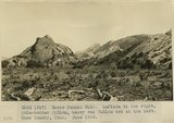
Water Pocket Fold. Looking north 30 degrees west along Hall Creek Valley near where stream leaves McElmo to enter LaPlata. Kane County, UT. June 1918 | P0013 Herbert E. Gregory Photograph Collection | P0013n08_071_1440 |
| 127 |
 |
Water Pocket Fold. LaPlata to the right, thin-bedded McElmo, heavy red McElmo bed at the left. Kane County, UT. June 1918 | P0013 Herbert E. Gregory Photograph Collection | P0013n08_072_1441 |
| 128 |
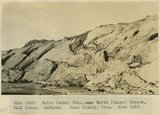 |
Water Pocket Fold, near Baker Ranch, Hall Creek. LaPlata. Kane County, UT. June 1918 | P0013 Herbert E. Gregory Photograph Collection | P0013n08_072_1442 |
| 129 |
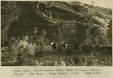 |
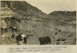
Water Pocket Fold, Cave Springs, Hanson Creek. Cow Camp. Kane County, UT. June 1918 | P0013 Herbert E. Gregory Photograph Collection | P0013n08_073_1443 |
| 130 |
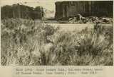 |
Water Pocket Fold, Colorado River, mouth of Hanson Creek. Kane County, UT. June 1918 | P0013 Herbert E. Gregory Photograph Collection | P0013n08_073_1444 |
| 131 |
 |
Water Pocket Fold, Hanson Creek, near mouth. Kane County, UT. June 1918. LaPlata sandstone | P0013 Herbert E. Gregory Photograph Collection | P0013n08_074_1445 |
| 132 |
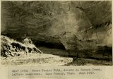 |
Water Pocket Fold, Alcove in Hanson Creek. LaPlata sandstone. Kane County, UT. June 1918 | P0013 Herbert E. Gregory Photograph Collection | P0013n08_074_1446 |
| 133 |
 |
Water Pocket Fold. Smith's Ranch, looking up Hall Creek north. Kane County, UT. June 1918 | P0013 Herbert E. Gregory Photograph Collection | P0013n08_075_1447 |
| 134 |
 |
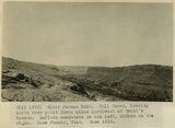
Water Pocket Fold. Smith's Ranch, looking north-northeast. McElmo strata and Dakota. Kane County, UT. June 1918 | P0013 Herbert E. Gregory Photograph Collection | P0013n08_075_1448 |
| 135 |
 |
Water Pocket Fold. Hall Creek, looking north from point three miles northwest of Smith's Ranch. LaPlata sandstone on the left, McElmo on the right. Kane County, UT. June 1918 | P0013 Herbert E. Gregory Photograph Collection | P0013n08_076_1449 |
| 136 |
 |
Water Pocket Fold. Smith's Ranch. Massive red McElmo, banded McElmo, Dakota on the top. Kane County, UT. June 1918 | P0013 Herbert E. Gregory Photograph Collection | P0013n08_076_1450 |
| 137 |
 |
Trail over Water Pocket Fold near Smith's Ranch. LaPlata sandstone. Kane County, UT. June 1918 | P0013 Herbert E. Gregory Photograph Collection | P0013n08_077_1451 |
| 138 |
 |
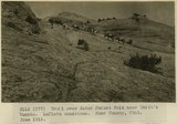
Trail over Water Pocket Fold near Smith's Ranch. LaPlata sandstone. Kane County, UT. June 1918 | P0013 Herbert E. Gregory Photograph Collection | P0013n08_077_1452 |
| 139 |
 |
Trail over Water Pocket Fold near Smith's Ranch. LaPlata sandstone. Kane County, UT. June 1918 | P0013 Herbert E. Gregory Photograph Collection | P0013n08_078_1453 |
| 140 |
 |
Crest of Water Pocket Fold, above Smith's Ranch. Kane County, UT. June 1918 | P0013 Herbert E. Gregory Photograph Collection | P0013n08_078_1454 |
| 141 |
 |
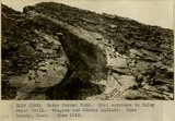
Crest of Water Pocket Fold, east face. Knobs of LaPlata sandstone. Kane County, UT. June 1918 | P0013 Herbert E. Gregory Photograph Collection | P0013n08_079_1455 |
| 142 |
 |
Water Pocket Fold. Hall Creek near slide. LaPlata sandstone to the left, McElmo capped by Dakota to the right. Kane County, UT. June 1918 | P0013 Herbert E. Gregory Photograph Collection | P0013n08_079_1456 |
| 143 |
 |
Water Pocket Fold. East entrance to Muley Twist Trail. Wingate and Middle LaPlata. Kane County, UT. June 1918 | P0013 Herbert E. Gregory Photograph Collection | P0013n08_080_1457 |
| 144 |
 |
Water Pocket Fold. West entrance to Muley Twist trail. Navajo on middle LaPlata. Kane County, UT. June 1918 | P0013 Herbert E. Gregory Photograph Collection | P0013n08_080_1458 |
| 145 |
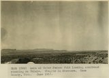 |
Axis of Water Pocket Fold looking southwest standing on Chinle. Wingate in distance. Kane County, UT. June 1918 | P0013 Herbert E. Gregory Photograph Collection | P0013n08_081_1459 |
| 146 |
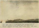 |
Axis of Water Pocket Fold looking south 30 degrees west from divide between Muley Twist and Silver Falls Canyon. Wingate sandstone. Kane County, UT. June 1918 | P0013 Herbert E. Gregory Photograph Collection | P0013n08_081_1460 |
| 147 |
 |
Scene in Silver Falls Canyon.Garfield County, UT. June 1918 | P0013 Herbert E. Gregory Photograph Collection | P0013n08_082_1461 |
| 148 |
 |
Upper Silver Falls Canyon. Chinle strata below Wingate. Garfield County, UT. June 1918 | P0013 Herbert E. Gregory Photograph Collection | P0013n08_082_1462 |
| 149 |
 |
Upper Silver Falls Canyon. Chinle beds below Wingate. Garfield County, UT. June 1918 | P0013 Herbert E. Gregory Photograph Collection | P0013n08_083_1463 |
| 150 |
 |
Silver Falls Canyon. Middle LaPlata and Navajo sandstone. Garfield County, UT. June 1918 | P0013 Herbert E. Gregory Photograph Collection | P0013n08_083_1464 |