Home
Browse
Ask Us
Chat
Harmful Language Statement
Log in
Advanced Search
Year
1830
1831
1832
1833
1834
1835
1836
1837
1838
1839
1840
1841
1842
1843
1844
1845
1846
1847
1848
1849
1850
1851
1852
1853
1854
1855
1856
1857
1858
1859
1860
1861
1862
1863
1864
1865
1866
1867
1868
1869
1870
1871
1872
1873
1874
1875
1876
1877
1878
1879
1880
1881
1882
1883
1884
1885
1886
1887
1888
1889
1890
1891
1892
1893
1894
1895
1896
1897
1898
1899
1900
1901
1902
1903
1904
1905
1906
1907
1908
1909
1910
1911
1912
1913
1914
1915
1916
1917
1918
1919
1920
1921
1922
1923
1924
1925
1926
1927
1928
1929
1930
1931
1932
1933
1934
1935
1936
1937
1938
1939
1940
1941
1942
1943
1944
1945
1946
1947
1948
1949
1950
1951
1952
1953
1954
1955
1956
1957
1958
1959
1960
1961
1962
1963
1964
1965
1966
1967
1968
1969
1970
1971
1972
1973
1974
1975
1976
1977
1978
1979
1980
1981
1982
1983
1984
1985
1986
1987
1988
1989
1990
1991
1992
1993
1994
1995
1996
1997
1998
1999
2000
2001
2002
TO
1830
1831
1832
1833
1834
1835
1836
1837
1838
1839
1840
1841
1842
1843
1844
1845
1846
1847
1848
1849
1850
1851
1852
1853
1854
1855
1856
1857
1858
1859
1860
1861
1862
1863
1864
1865
1866
1867
1868
1869
1870
1871
1872
1873
1874
1875
1876
1877
1878
1879
1880
1881
1882
1883
1884
1885
1886
1887
1888
1889
1890
1891
1892
1893
1894
1895
1896
1897
1898
1899
1900
1901
1902
1903
1904
1905
1906
1907
1908
1909
1910
1911
1912
1913
1914
1915
1916
1917
1918
1919
1920
1921
1922
1923
1924
1925
1926
1927
1928
1929
1930
1931
1932
1933
1934
1935
1936
1937
1938
1939
1940
1941
1942
1943
1944
1945
1946
1947
1948
1949
1950
1951
1952
1953
1954
1955
1956
1957
1958
1959
1960
1961
1962
1963
1964
1965
1966
1967
1968
1969
1970
1971
1972
1973
1974
1975
1976
1977
1978
1979
1980
1981
1982
1983
1984
1985
1986
1987
1988
1989
1990
1991
1992
1993
1994
1995
1996
1997
1998
1999
2000
2001
2002
Type
Image/StillImage
271
Image
217
Text
88
Format
image/jpeg
468
application/pdf
112
Collection
Beckwith Photograph Collection
48
Photo Archives
241
Ski and Snow Sports Archives
127
UAIDA Main Collection
195
Utah Humanities Research Foundation
19
Utah Quilt Heritage Records
50
Utah River Running Photo Archives
13
Western Waters NEH
8
Westminster College Photographs
4
More
Filters:
Spatial Coverage:
"Iron County (Utah)"
526
-
550
of
705
<
17
18
19
20
21
22
23
24
25
26
>
Gallery view
Number of results to display per page
10
25
50
100
200
Sort by Relevance
Sort by Title A-Z
Sort by Title Z-A
Sort by Date Ascending
Sort by Date Descending
Sort by Last Modified Ascending
Sort by Last Modified Descending
Title
Date
Type
Setname
526
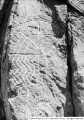
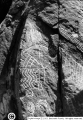
Petroglyphs; Parowan Gap; Iron County, Utah [XVII]
1929
Image/StillImage
uaida_main
527
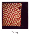
Pink Feather Scrap Bag Square quilt by Hannah Jane Clove Robinson
1960
Text
uum_uqhr
528
Pink Lone Star quilt by Unknown quilter
1840; 1841; 1842; 1843; 1844; 1845; 1846; 1847; 1848; 1849; 1850
Text
uum_uqhr
529
Pink patch quilt
1930; 1931; 1932; 1933; 1934; 1935; 1936; 1937; 1938; 1939; 1940; 1941; 1942; 1943; 1944; 1945; 1946; 1947; 1948; 1949; 1950; 1951; 1952; 1953; 1954; 1955; 1956; 1957; 1958; 1959; 1960; 1961; 1962; 1963; 1964; 1965; 1966; 1967; 1968; 1969; 1970; 1971; 1972; 1973; 1974; 1975; 1976; 1977; 1978; 1979; ...
Text
uum_uqhr
530
Pink Triangles quilt by Mary Anne Willamson Robinson
1880
Text
uum_uqhr
531
Piute Highlands. Glacial lake and moraine, Moseman (Dry Lakes) Valley. Iron County, UT, 1942
1942
Image
uum_map
532
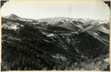
Piute Highlands. View looking north from near the base of Eagle Peak across branches of Summit Creek. Parowan Creek to snow capped Tushar Mountains (skyline); rhyolite and Cretaceous in the foreground; Cretaceous, Tertiary, and lavas beyond. Iron County, UT, 1942
1942
Image
uum_map
533
Piute Highlands. View looking northeast across Parowan and Benson Canyons from base of Applegate Ridge. Rim of Markagunt Plateau (middle skyline); Knob and ridges of Wasatch (middle distance); rhyolite foreground. Iron County, UT. 1942
1942
Image
uum_map
534
Piute Highlands. View looking northeast across Parowan and Benson Canyons from base of Applegate Ridge. Rim of Markagunt Plateau (middle skyline); Knob and ridges of Wasatch (middle distance); rhyolite foreground. Iron County, UT. 1942
1942
Image
uum_map
535
Piute Highlands. View looking south from Applegate Ridge across upper Summit Creek. Wasatch in Sugar Loaf Peak (upper left); rhyolite on Summit ridge, middle skyline; Cretaceous (foreground). Iron County, UT, 1942
1942
Image
uum_map
536
Pond confined by a glacial moraine. Dry Lakes road, Iron County, UT, 1942
1942
Image
uum_map
537
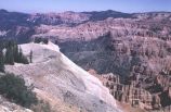
Portion of two-mile trail at Cedar Breaks
1966-07-04
Image
uum_map
538
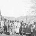
Presenting homes to Cedar Indians; Cedar City, Iron County, Utah
1925-12-25
Image/StillImage
uaida_main
539
President Warren G Harding Party, 1923: Presidential motorcade
1923-06-27
Image/StillImage
uum_map
540
Rainbow Youth
Image
dc_bpc
541
Rainbow Youth
Image
dc_bpc
542
Rainbow Youth [1]
1939
Image
dc_bpc
543
Rainbow Youth [2]
1939
Image
dc_bpc
544
Rainbow Youth [3]
1941-07-18
Image
dc_bpc
545
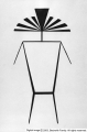
Rayed man
Image
dc_bpc
546
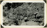
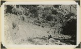
Recent trenching of valley fill of stratified sands and clay, upper part of Spring Creek Canyon, Iron County, UT, 1942
1942
Image
uum_map
547
Recent trenching of valley fill of stratified sands and clay, upper part of Spring Creek Canyon, Iron County, UT, 1942
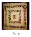
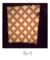
1942
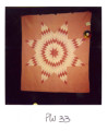
Image
uum_map
548
Red & White Geomtric quilt by Unknown quilter
1840; 1841; 1842; 1843; 1844; 1845; 1846; 1847; 1848; 1849; 1850
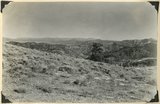
Text
uum_uqhr
549
Red & White Pieced quilt by Unknown quilter
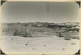
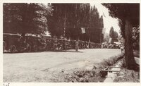
1840; 1841; 1842; 1843; 1844; 1845; 1846; 1847; 1848; 1849; 1850
Text
uum_uqhr
550
Rena; Cedar City, Iron County, Utah
1936
Image/StillImage
uaida_main
526
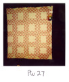
-
550
of
705
<
17
18
19
20
21
22
23
24
25
26
>