Home
Browse
Ask Us
Chat
Harmful Language Statement
Log in
Theses & Dissertations
Advanced Search
Year
1950
1951
1952
1953
1954
1955
1956
1957
1958
1959
1960
1961
1962
1963
1964
1965
1966
1967
1968
1969
1970
1971
1972
1973
1974
1975
1976
1977
1978
1979
1980
1981
1982
1983
1984
1985
1986
1987
1988
1989
1990
1991
1992
1993
1994
1995
1996
1997
1998
1999
2000
2001
2002
2003
2004
2005
2006
2007
2008
2009
2010
2011
TO
1950
1951
1952
1953
1954
1955
1956
1957
1958
1959
1960
1961
1962
1963
1964
1965
1966
1967
1968
1969
1970
1971
1972
1973
1974
1975
1976
1977
1978
1979
1980
1981
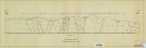
1982
1983
1984
1985
1986
1987
1988
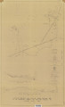
1989
1990
1991
1992
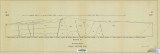
1993
1994
1995
1996
1997
1998
1999
2000
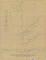
2001
2002
2003
2004
2005
2006
2007
2008
2009
2010
2011
School Or College
College of Mines & Earth Sciences
131
College of Architecture & Planning
10
College of Mines and Earth Sciences
4
Department
Geology & Geophysics
114
Materials Science & Engineering
12
Architecture
10
Mining Engineering
9
Publication Type
thesis
145
Subject
Utah
40
Geology
36
Thesis and dissertation georeferencing project
15
Thesis and dissertation georeferencing project
12
Stratigraphic
10
Geology -- Utah -- Tooele County
7
Geology -- Utah -- Summit County
6
Summit County
6
Wasatch County
5
Basalt -- Utah
4
Coalville region
4
Geology -- Utah -- Beaver County
4
Geology -- Utah -- Box Elder County
4
Grand County
4
Sediments (Geology)
4
Beaver County
3
Box Elder County
3
Carbon County
3
Crystalline
3
Geology -- Structural -- Utah -- Willard Peak area
3
Geology -- Utah -- Juab County
3
Geology -- Utah -- Mineral Mountains
3
Geology -- Utah -- Sheeprock Mountains
3
Geology -- Utah -- Weber County
3
Geology--Utah
3
Granite
3
Metamorphic
3
Millard County
3
Mineral Range (Utah)
3
Moenkopi group
3
Mount Ogden
3
Newfoundland Mountains
3
Petrology -- Utah -- Beaver County
3
Precambrian
3
Rocks
3
Silver Island Mountains
3
Stansbury Island
3
Tertiary
3
Thaynes Formation
3
Utah County
3
Wasatch Hinterland
3
Geothermal resources -- Utah
2
Bonneville
2
Cretaceous
2
Geology -- Uinta Mountains (Utah and Wyo.)
2
Geology -- Utah -- Grassy Mountains -- Maps
2
Geology -- Utah -- Kane County
2
Geology -- Utah -- Kane County -- Paria Northwest quadrangle
2
Geology -- Utah -- Lakeside Mountains -- Maps
2
Geology -- Utah -- Morgan County
2
Geology -- Utah -- Upton area
2
Geology, Economic -- Utah -- Sulphurdale
2
Geothermal resources -- Utah
2
Great Salt Lake Basin
2
Juab County
2
Landslides -- Utah -- Kane County
2
Mesozoic
2
Mines and mineral resources -- Utah -- Deep Creek Mountains
2
Mines and mineral resources -- Utah -- Sulphurdale
2
Petrology
2
Petrology -- Utah -- Wasatch Mountains
2
Salt Lake County
2
Sulphur mines and mining -- Utah -- Sulphurdale
2
Uinta Basin (Utah and Colo.)
2
Cedar Mountains
1
Cove Creek area
1
Designs
1
Faults (Geology) -- Nevada -- Lincoln County,Nye County
1
Geochemistry
1
Geology -- Utah -- Juab County -- Tintic Mining District
1
Geology -- Utah -- Ogden Valley
1
Geology -- Utah -- Silver Island Mountains
1
Geology: Stratigraphic-Paleozoic
1
Groundwater -- Utah -- Ogden Valley
1
Lake
1
Mineralogy
1
Mines and mineral resources-Beaver County
1
Natural gas
1
Ore deposits
1
Plans
1
Recreation centers
1
Stratigraphic geology
1
Stratigraphic-Mesozoic
1
Structural
1
Thesis and dissertation dereferencing project
1
Tooele County
1
Uinta Mountains
1
Utah-Star Range
1
Volcanism -- Nevada -- Lincoln County, Nye County
1
More
Filters:
Publication Type:
"thesis"
Collection:
"ir_etd"
Type:
"Image"
101
-
125
of
145
<
1
2
3
4
5
6
>
Gallery view
Number of results to display per page
10
25
50
100
200
Sort by Relevance
Sort by Title A-Z
Sort by Title Z-A
Sort by Date Ascending
Sort by Date Descending
Sort by Last Modified Ascending
Sort by Last Modified Descending
Author
Title
Subject
Date
Publication Type
101
Johnson, Eric Henry
Plate 2 Topography, resistivity, and chargeability cross-sections along dipole-dipole line 1 on Fumarole Butte
Basalt -- Utah; Geothermal resources -- Utah
1975-08
thesis
102
Baker, Walker Holcombe
Plate 2: Cross-section A-A'
1959-06
thesis
103
Rodriguez, Enrique Levy
Plate 2: Detailed geologic and vertical cross sections map of the Excelsior Orebody and New York Prospect Pit, Millard County, Utah
1960-08
thesis
104
Neff, Thomas Rodney
Plate 2: Sections along line A-A' and B-B'
1962-11
thesis
105
Blakey, Ronald Clyde
Plate 2: Structural sections
1970-08
thesis
106
Sadeghi, Ali Reza
Plate 2: Structure sections for geologic map of the Willard Peak area
1972-12
thesis
107
Hooper, Warren G.
Plate 3 Geologic map of portion of Northwestern Uinta Mountains, Utah (Google Earth map overlay KMZ file)
Geology -- Uinta Mountains (Utah and Wyo.); Thesis and dissertation georeferencing project
1951
thesis
108
Johnson, Eric Henry
Plate 3 Topography, resistivity, and chargeability cross-sections along dipole-dipole line 2 on Fumarole Butte
Basalt -- Utah; Geothermal resources -- Utah
1975-08
thesis
109
Baker, Walker Holcombe
Plate 3: Cross-section B-B'
1959-06
thesis
110
Rodriguez, Enrique Levy
Plate 3: Detailed geologic and vertical cross section map of the Prince Albert Orebody, Mariposa and Queen Victoria Prospect Pits, Millard County, Utah
1960-08
thesis
111
Mount, Donald Lee
Plate 3: Geologic map and sections of Wanship-Park City region, Utah
1952-06
thesis
112
Mount, Donald Lee
Plate 3: Geologic map and sections of Wanship-Park City region, Utah (Google Earth map overlay KMZ file)
Geology -- Utah -- Summit County
1952-06
thesis
113
Hooper, Warren G.
Plate 3: Geologic map of portion of Northwestern Uinta Mountains, Utah
1951
thesis
114
Sadeghi, Ali Reza
Plate 3: Palinspastic middle and upper Cambrian columnar sections from western and northern Utah
1972-12
thesis
115
Neff, Thomas Rodney
Plate 3: Structural map of the Little Willow Series, Wasatch Mountains, Utah
1962-11
thesis
116
Blakey, Ronald Clyde
Plate 3: Structural map of the Paria NW quadrangle, Kane County, Utah
1970-08
thesis
117
Blakey, Ronald Clyde
Plate 3: Structural sections
1970-08
thesis
118
Sadeghi, Ali Reza
Plate 4: Correlation of Precambrian rocks of the lower plate and upper plate of the Willard thrust with the Huntsville and Cottonwood areas
1972-12
thesis
119
Rodriguez, Enrique Levy
Plate 4: Detailed map showing diamond drill hole locations and vertical cross sections of the Sulphurdale Orebody, Beaver County, Utah
1960-08
thesis
120
Baker, Walker Holcombe
Plate 4: Evolution of the eastern fault block
1959-06
thesis
121
Neff, Thomas Rodney
Plate 4: Map variations of the Little Willow Series, Wasatch Mountains, Utah
1962-11
thesis
122
Blakey, Ronald Clyde
Plate 4: Topographic features of the Paria NW quadrangle, Kane County, Utah
1970-08
thesis
123
Stark, Norman Paul
Plate 5: Geologic map of the Upton region, Summit County, Utah (Google Earth map overlay KMZ file)
Geology -- Utah -- Upton area; Summit County; Coalville region; Thesis and dissertation georeferencing project
1953-06
thesis
124
Johnson, Eric Henry
Plate1 Map of Fumarole Butte showing topography, geology, and locations of dipole-dipole profiles and Schlumberger soundings
Basalt -- Utah; Geothermal resources -- Utah
1975-08
thesis
125
Earll, Fred Nelson
Plate1-part1 Geologic map of the Central Mineral Range, Beaver County, Utah
Geology -- Utah -- Mineral Mountains; Geology -- Utah -- Beaver County
1957-08
thesis
101
-
125
of
145
<
1
2
3
4
5
6
>