|
|
Title | Collection Number And Name | Photo Number |
| 151 |
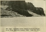 |
Colorado River looking south 3+ miles above Hite, Garfield County, Utah, June 19, 1915. | P0013 Herbert E. Gregory Photograph Collection | P0013n08_032_1372 |
| 152 |
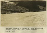 |
Crossing of Colorado River 3+ miles above Hite, Garfield County, Utah. Note horses swimming. June 19, 1915. | P0013 Herbert E. Gregory Photograph Collection | P0013n08_033_1373 |
| 153 |
 |
Camp south edge of Elk Ridge at head of Grand Gulch, San Juan County, Utah. June, 1915. | P0013 Herbert E. Gregory Photograph Collection | P0013n08_033_1374 |
| 154 |
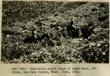 |
Vegetation south slope of Bears Ears, Elk Ridge, San Juan County, Utah. June, 1915. | P0013 Herbert E. Gregory Photograph Collection | P0013n08_034_1375 |
| 155 |
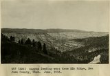 |
Canyon leading west from Elk Ridge, San Juan County, Utah. June, 1915. | P0013 Herbert E. Gregory Photograph Collection | P0013n08_034_1376 |
| 156 |
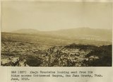 |
Abajo Mountains looking east from Elk Ridge across Cottonwood Canyon, San Juan County, Utah. June, 1915. | P0013 Herbert E. Gregory Photograph Collection | P0013n08_035_1377 |
| 157 |
 |
Camp, Bears Ears, Elk Ridge, Utah. June, 1915. | P0013 Herbert E. Gregory Photograph Collection | P0013n08_035_1378 |
| 158 |
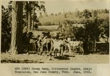 |
Sheep Camp, Cottonwood Canyon, Abajo Mountains, San Juan County, Utah. June, 1915. | P0013 Herbert E. Gregory Photograph Collection | P0013n08_036_1379 |
| 159 |
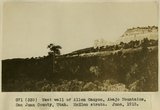 |
West wall of Allen Canyon, Abajo Mountains, San Juan County, Utah. McElmo strata. June, 1915. | P0013 Herbert E. Gregory Photograph Collection | P0013n08_036_1380 |
| 160 |
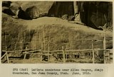 |
LaPlata sandstone near Allen Canyon, Abajo Mountains, San Juan County, Utah. June, 1915. | P0013 Herbert E. Gregory Photograph Collection | P0013n08_037_1381 |
| 161 |
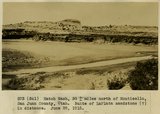 |
Hatch Wash, 30+ miles north of Monticello, San Juan County, Utah. Butte of LaPlata sandstone (?) in distance. June 28, 1915. | P0013 Herbert E. Gregory Photograph Collection | P0013n08_037_1382 |
| 162 |
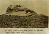 |
Looking Glass Rock, Dry Valley, San Juan County, Utah. June, 1915. | P0013 Herbert E. Gregory Photograph Collection | P0013n08_038_1383 |
| 163 |
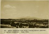 |
LaSale Mountains from south looking across platform of LaPlata sandstone, June 1915. | P0013 Herbert E. Gregory Photograph Collection | P0013n08_038_1384 |
| 164 |
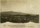 |
Abajo Mountains from southwest, [Probably from southern end of Elk Ridge] | P0013 Herbert E. Gregory Photograph Collection | P0013n08_039_1385 |
| 165 |
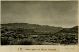 |
Lower part of White Canyon? | P0013 Herbert E. Gregory Photograph Collection | P0013n08_039_1386 |
| 166 |
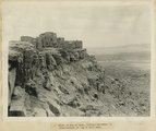 |
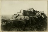
Walpi on top of mesa, looking southwest to Mishonginovi on top of next mesa | P0013 Herbert E. Gregory Photograph Collection | P0013n08_044_1392 |
| 167 |
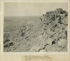 |
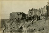
Walpi. The southeastern side of the mesa. Note sheep folds at base of mesa (lower left), also growing corn out on the desert, all a fine yellow sand | P0013 Herbert E. Gregory Photograph Collection | P0013n08_045_1393 |
| 168 |
 |
Tewa Pueblo, 'Hano,' on top of mesa near Walpi, built around a court, left center showing opening between houses with buildings (doorway and window) across the court | P0013 Herbert E. Gregory Photograph Collection | P0013n08_046_1394 |
| 169 |
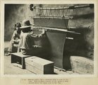 |
Weaving prayer rug in deserted kiva or cave in the rock. Note diagonal texture of the weave-a very ancient weave and known only to the Hopi | P0013 Herbert E. Gregory Photograph Collection | P0013n08_047_1395 |
| 170 |
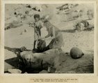 |
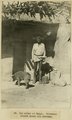
Hopi woman washing in natural basin on hill near the spring. She brought water in nearby olla | P0013 Herbert E. Gregory Photograph Collection | P0013n08_048_1396 |
| 171 |
 |
Chief Harry Supela (naked) about to enter snake kiva at Walpi, morning of snake dance. Great altar is partly seen through the covered passage way | P0013 Herbert E. Gregory Photograph Collection | P0013n08_049_1397 |
| 172 |
 |
After the dance, Walpi, AZ | P0013 Herbert E. Gregory Photograph Collection | P0013n08_050_1398 |
| 173 |
 |
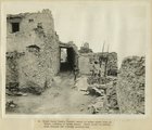
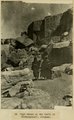
Walpi-the east end of the pueblo. Note deep trail worn into the edge of mesa top | P0013 Herbert E. Gregory Photograph Collection | P0013n08_050_1399 |
| 174 |
 |
Old crier of Walpi. Firewood stored above his doorway | P0013 Herbert E. Gregory Photograph Collection | P0013n08_051_1400 |
| 175 |
 |
Hopi women on the trail to Mishonginovi, AZ | P0013 Herbert E. Gregory Photograph Collection | P0013n08_051_1401 |